|
|
Mountain/Rock |
|---|---|
|
|
52.89364°N / 3.99097°W |
|
|
Gwynedd |
|
|
Hiking, Trad Climbing, Bouldering, Scrambling |
|
|
Spring, Summer, Fall, Winter |
|
|
2014 ft / 614 m |
|
|
Overview
Sitting astride the spine of the Harlech Dome like some Tolkienian fortress, Foel Penolau (614m) is perhaps the most distinctive feature of the northern Rhinogydd. Depending on what you want to believe, its name either means Bare Last Summit or Bare Hill of the Bottoms; both seem appropriate, there’s a great aura of terminality about this place. Despite being 9 metres shorter than its close neighbour Moel Ysgyfarnod, it’s a far more attractive proposition, being on the whole a much rockier and more formidable beast; its flat slabby summit being completely encircled by cliffs and broken stone. To reach the summit therefore, one must pull their hands out of their pockets and tackle them via the weakness of their choice, a task most mountaineers will undertake with gusto. Despite being a relatively well known summit, rock climbing did not arrive at Foel Penolau until 1997; since then a handful of good quality routes have been recorded on its southern side. This is wilderness climbing at its very best and if you want to climb here you will need to make the not inconsiderable effort to drag your gear many miles to experience it. Those that do will find excellent, steep and quick drying rock, which boasts some of the best views in Snowdonia. There’s little for the novice here though, with the easiest route coming in at a respectable Very Severe 4b. Get the most out of your visit by combining your trip with stops off at the crags of Moel Ysgyfarnod or Craig y Gwynt. |
Rock Climbing


The south face of Foel Penolau is a fantastic south facing crag, with some great routes on perfect, quick drying Rhinog grit - without a doubt one of the best crags in the area. Unless otherwise stated, routes are listed from left to right, and are graded and rated with the aid of the Climbers Club Guide to Meirionnydd, so for full descriptions, please refer to this source. The Climbers’ Club have also produced a free pdf, which provides details of first ascents recorded after 2001: download it here. Technical grades are generally only given to climbs graded adjectivally as Hard Severe (HS) or above. Please be aware that the Rhinog Range is a trad climbing venue and bolting is strictly prohibited. Routes are rated using the British Adjectival Grading System. A conversion table of international climbing grades by SP member Corax is available HERE! |

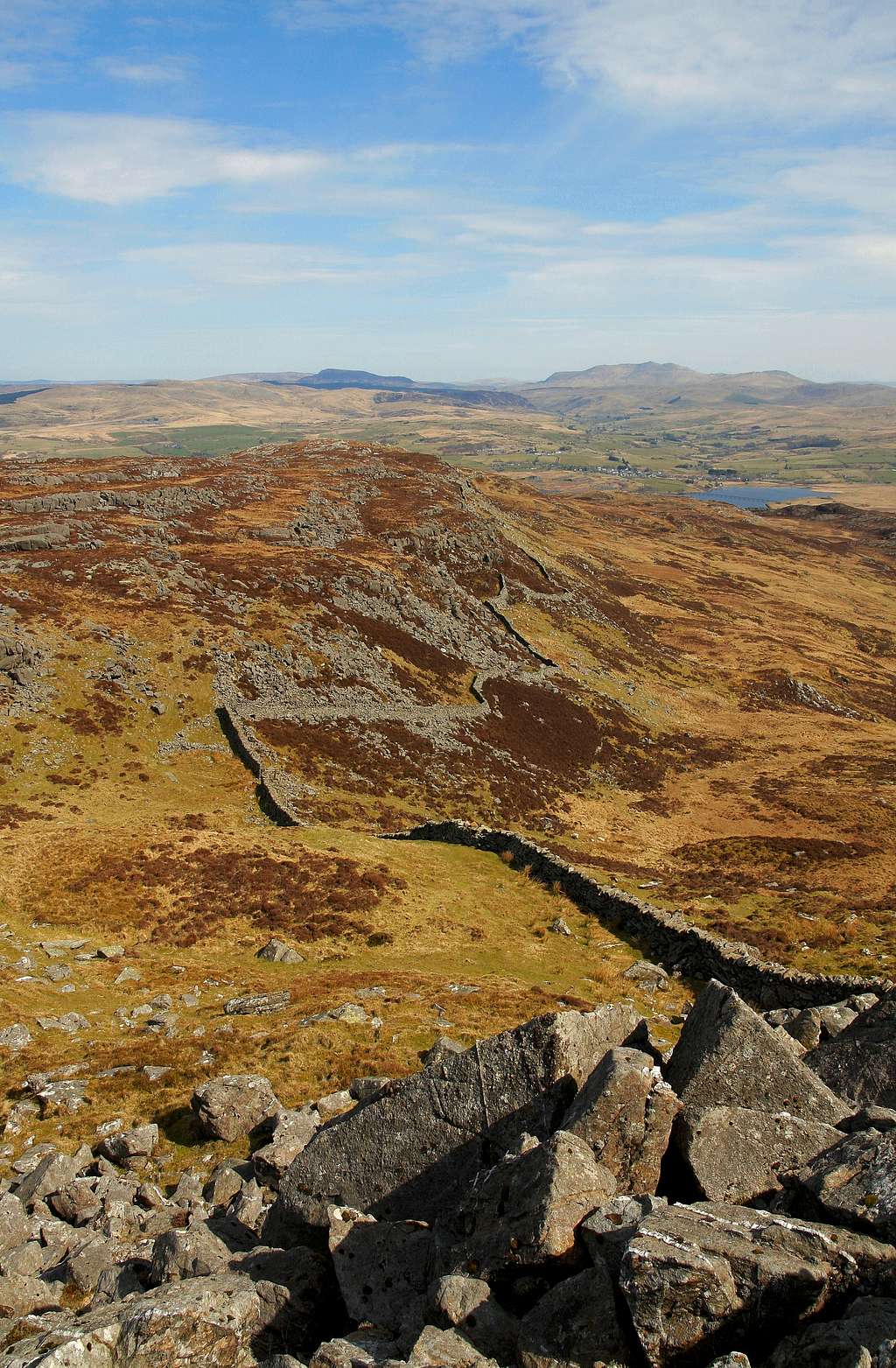
Foel Penolau (Photo by Nanuls)
Route Symbols:
South FaceThe first two routes embark from a broad platform at the left-had end of the main crag. |


Routes on the South Face of Foel Penolau
| No. | Name | Length | Pitches | Adjectival Grade | Technical Grade | Quality | Restrictions |
|---|---|---|---|---|---|---|---|
| 1. | Purrfection | 7m | 1 | E1 | 5a |  | |
| 2. | Small Wonder | 9m | 1 | VS | 4b |  | |
| 3. | Grach | 12m | 1 | E1 | 5b | | |
| 4. | On Secret Sand | 15m | 1 | E3 | 6a | | |
| 5. | Silence is Goldern | 15m | 1 | E5 | 6a | | |
| 6. | All This and Heaven Too | 15m | 1 | E3 | 5c | | |
| 7. | Politician's Wall | 15m | 1 | E4 | 6b | | |
| 8. | Misunderstood | 15m | 1 | E1 | 5b | | |
| 9. | Do the Monkey | 13m | 1 | E2 | 5c | | |
| 10. | Stranger's Solace | 13m | 1 | E1 | 5a | | |
| 11. | Subterranean Leg Injector | 15m | 1 | E2 | 5b | | |
| 12. | In Whose Footsteps? | 12m | 1 | HVS | 4c | | |
| 13. | Greywacke Race | 10m | 1 | E3 | 6a | | |


| No. | Name | Length | Pitches | Adjectival Grade | Technical Grade | Quality | Restrictions |
|---|---|---|---|---|---|---|---|
| 14. | Dehydration | 8m | 1 | E3 | 6a | | |
| 15. | Dry Throat of Fear | 8m | 1 | E3 | 6a | | |
| 16. | The Last Nut on Earth | 10m | 1 | E3/4 | 5c | | |
| 17. | Don't Poop on my Parade | 10m | 1 | HVS | 5b | | |
| 18. | A Fut Above the Rest | 10m | 1 | E2 | 6a | | |
Mountain Conditions
This section displays the mountain conditions for Snowdonia, of which Foel Penolau is a part. Click on the widget for maps and further information. This Snowdonia weather forecast is generated by the Met Office Weather Widget |
When to Climb and Essential Gear
Foel Penolau can be climbed at anytime of the year, however, in poor conditions the mountain's rock routes are best avoided, particularly if the weather's been wet. March to September offer the most reliable conditions. Of course this all depends on ones ability as a mountaineer/climber, and what might be comfortable for some may seem daunting for others. If your lucky enough to climb the mountains in winter conditions then an ice axe and crampons are essential. |
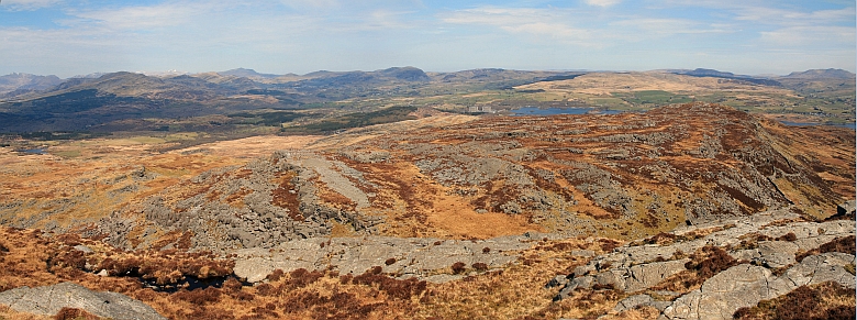
Diffwys from Foel Penolau (Photo by Nanuls)
Getting There
Foel Penolau is located in the northern half of the Rhinogydd and is one of the range’s least visited summits. It can be approached from its east via the A470(T), which runs from Dolgellau to Conwy and Colwyn Bay, or the west, via the smaller A496, which runs along the coast from Llanulltyd near Dolgellau and around to Blaenau Ffestiniog in the north. If approaching from the east you will need to leave the A470(T) at the minor junction at Cefn-gallt-y-cwm (SH 710 345) and travel in a westward direction along the southern shores of Llyn Trawsfynydd. A second junction will be reached after around 1.5km (SH 696 347), take the right fork here and continue along the western shore of the lake. Park near Moelfryn-uchaf (SH 684 358) and follow the nearest right of way into the range. Soon the paths will run out and you will have to find your own way. An arguably better approach is from the west, which takes slightly longer to get to. Leave the A470(T) at Maentwrog (SH 665 407) and follow the A496 westwards along the river towards Harlech. After about 10km you’ll reach the junction with the B4573 (SH 606 349). It’s an unusual junction, because rather than turning off onto the B4573 you carry straight on (the turn off is actually for the A470(T)). Continue along the B4573 past the row of houses at Glan-y-Wern until you reach a small stone bridge over a stream. There is a junction at this bridge signposting Eisingrug (SH 615 345); turn off here and follow the minor road to Eisingrug. At Eisingrug take the second minor road on the right (it’s hard to spot, joining the road your on between a field boundary and a stone building), and follow it to its terminus. Here you will find a small grassy parking area and the start of the Miners Track (SH 628 342). There is a payment of £2 to be made for using the car park, which is placed in a box attached to the landowner’s gate. Payments made for parking are donated to the Wales Air Ambulance Service. |
Red Tape and Access
No red tape here! For climbers, hill walkers and mountaineers, the British Mountaineering Council (BMC) runs a Regional Access Database, which holds mountain/crag specific information on matters of conservation and access, including issues such as nesting restrictions, nature designations and preferred parking. If you are in any doubt about any particular access arrangement, or need to report an incident, you should contact your local BMC Access Representative or the BMC Access Officers for Wales: Elfyn Jones. |


Camping and Accommodation
There’s an almost unlimited supply of accommodation within the Snowdonia National Park so it would be inappropriate to list it all here. For budget accommodation it’s worth checking out some of the following sites: Youth Hostel Association in WalesIndependent Hostel GuideCampsites in Gwynedd For more local options, there are a number of campsites that surround the range; Cae Adda (SH 690 355), which is near Llyn Trawsfynydd or Bryn Bwbach (SH 620 368) on the opposite side of the range. |
Maps
|
| Navigation Maps OS 1:25k Explorer Series OL 18 Harlech, Porthmadog & Bala/Y Bala OS 1:50k Landranger Series 124 Porthmadog & Dolgellau Harvey Map Services 1:25k Snowdonia South Rhinogs/Rhinogydd Road Maps OS Road Map 9 Wales/Cymru & West Midlands |
Guidebooks
|
|


External Links
 Foel Penolau (Photo by Nanuls) Foel Penolau (Photo by Nanuls)Government Bodies and Official Organisations Snowdonia National Park Authority Association of National Park Authorities Royal Commission on Ancient & Historical Monuments in Wales Hiking, Climbing and Mountaineering Organisations and Companies British Mountaineering Council Plas y Brenin National Mountain Centre Weather Tourist Information North Wales Tourism Partnership Local Information from Gwynedd.com Local Information from Snowdonia Wales Net Travel Welsh Public Transport Information Accommodation Youth Hostel Association in Wales Maps and Guidebooks Cordee Travel and Adventure Sports Bookshop Wildlife and Conservation |