
-
 15326 Hits
-
 84.82% Score
-
 19 Votes
|
|
Mountain/Rock |
|---|---|
|
|
38.29263°N / 119.64189°W |
|
|
Tuolumne |
|
|
Hiking |
|
|
Summer |
|
|
11265 ft / 3434 m |
|
|
Overview
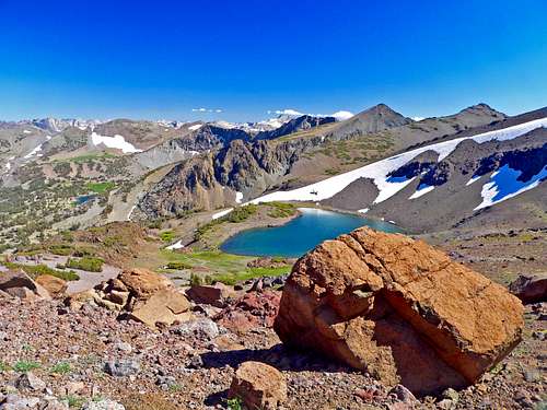
South from pass 10,800, Latopie Lake below
Getting There
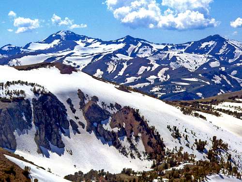
West to the Sierra crest south of Sonora Pass, L-R: Leavitt Peak, "Latopie Peak" and "Pacific Crest Peak" from Mt. Emma, 10,525'
Route: Take the PCT south as it climbs to the crest and goes along the west slopes of the first two peaks until it reaches a saddle at 3 miles. The north ridge of "Latopie Peak" is directly ahead. The PCT then drops down to the left and goes along below the northeast face of "Latopie Peak" until it reaches a pass (10,800') at 3.7 miles. Continue on over the pass above Latopie Lake as it goes down to the right for .5 miles and climb up to a small saddle between "Latopie Peak" and Leavitt Peak. Take the southwest ridge to the summit (class 2-3). Of course the north ridge class 2-3 is more direct but gets quite serious near the top. There is a steel cable high along the steep desolate west slope to provide a traverse, kinda like on Half Dome. I would not attempt this baren crumbly slope without the cable. At the end of the traverse you wind up near the top of the southwest ridge. The northeast face looks to be at least class 4 on potentially dubious rock. ![Sierra Crest from Leavitt Peak]()
Northeast from Leavitt Peak, "Latopie Peak", lower rightHwy. 108, as it approaches Sonora Pass from east or west gets steep and narrow with hairpin turns. Not recommended for RVs. The peak is on the border of the Emmigrant Wilderness and the Toiyabe National Forest. No permits are required for day hiking.
EUREKA VALLEY, 28 sites, el. 6000', along Hwy. 108 2.3 miles east of Dardenelles Resort and 2,7 miles west of Kennedy Meadows Road junction. BAKER, 44 sites, 6,250' at the start of the Kennedy Meadows Road junction.
DEADMAN, 17 sites, 6,300', just .6 miles along the Kennedy Meadows Road.
CHIPMUNK, 7,950, along Hwy. 108, 4,7 miles west of Sonora Pass.
LEAVITT MEADOWS, 16 sites, 7,150', along Hwy. 108 7,8 miles east of Sonora Pass and 7,3 miles east of Hwy. 395.
SONORA BRIDGE, 23 sites, 6,800', along Hwy. 108 1.4 miles west of Hwy. 395.
Red Tape

Northeast from Leavitt Peak, "Latopie Peak", lower right
Camping
CAMPGROUNDS IN THE VICINITY:EUREKA VALLEY, 28 sites, el. 6000', along Hwy. 108 2.3 miles east of Dardenelles Resort and 2,7 miles west of Kennedy Meadows Road junction. BAKER, 44 sites, 6,250' at the start of the Kennedy Meadows Road junction.
DEADMAN, 17 sites, 6,300', just .6 miles along the Kennedy Meadows Road.
CHIPMUNK, 7,950, along Hwy. 108, 4,7 miles west of Sonora Pass.
LEAVITT MEADOWS, 16 sites, 7,150', along Hwy. 108 7,8 miles east of Sonora Pass and 7,3 miles east of Hwy. 395.
SONORA BRIDGE, 23 sites, 6,800', along Hwy. 108 1.4 miles west of Hwy. 395.