
-
 10685 Hits
-
 85.36% Score
-
 20 Votes
|
|
Mountain/Rock |
|---|---|
|
|
46.96456°N / 11.40587°E |
|
|
Hiking, Skiing |
|
|
Spring, Summer, Fall, Winter |
|
|
7667 ft / 2337 m |
|
|
Overview
 Grubenkopf as seen from the Ridge coming from Portjoch Grubenkopf as seen from the Ridge coming from Portjoch |
At its eastern end, east of the Tribulaun Group, the Stubai Alps Main Ridge splits into two branches and quite suddenly drops from more than 3000m elevation to between 2200m and 2400m. Both main ridges - as well as their side ridges - stay at more or less the same elevation before suddenly dropping another 800m towards Brenner Pass. Consequently the whole area is a veritable hiker's paradise with unobstructed views to all sides. Thanks to the elevation difference only the mountains closest to Brenner Pass can be called crowded. Make no mistake, even the summits further away are not actually lonesome but you will find plenty of time to enjoy the vista.
On the southern of the two main ridges you find three summits clustered together, all three at aproximately the same elevation: Grubenkopf / Monte delle Cave (2337m), Geierskragen / Cima degli Avoltoi (2309m) and Hoher Lorenzen / Monte San Lorenzo (2313m). Of the three Hoher Lorenzen is the most popular, mainly due to its proximity to Brenner Pass, but also because of a mountain road, which was built during the later part of WWII by Russian POWs. This road, which connects Brenner Pass with Sandjöchl, the saddle between Hoher Lorenzen and Geierskragen. The road is very popular among mountain bikers which results in Geierskragen also being visited quite often.
The remotest of the three summits is Grubenkopf, which is coincidentally also the highest of the lot. The standard route to its summit starts to the north of the ridge in Obernberg Valley and heads for the Portjoch Saddle to the west of the mountain. From there a beautiful ridge traverse leads to the summit a route, which follows the Austrian-Italian border for all the way. Part of the border is "secured" by barbed wire fences, an anachronism in the era of open European borders. A closer look, however,
reveals that the fences have been installed to keep sheep and goats in their respective pastures, a rule the animals consequently ignore. Today the border is solely indicated by the trigonometric markers, which were set up in 1921, when the two countries finally agreed on the exact course of the border.
The south face of the mountain drops off in a steep slope towards the Pflersch Valley / Val di Fleres 1300m below. Through this slope - or should I rather say within this slope - there is one of the wonders of engineering which the early 20th century created. In order to circumvent the Eisacktal Gorge between Brenner Pass and the village of Gossensass / Colle Isarco a huge tunnel loop was constructed for the Brenner Railroad. This loop almost touches the exact locations of the three summits, only 1000m underneath.
|


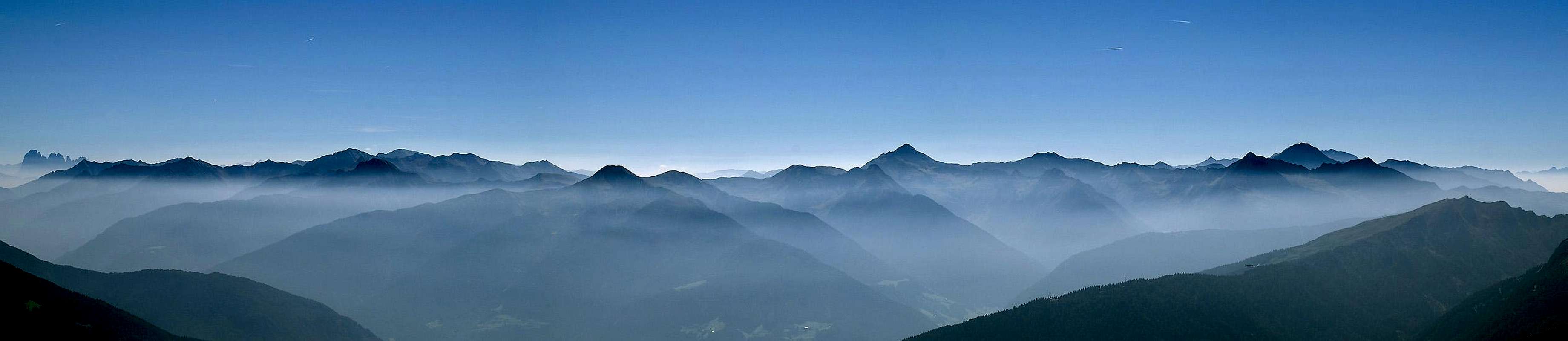
The Summit Panorama
KreuzjochHohe WarteSattelbergKl. KasererGr. KasererOlpererFußsteinVennspitzeHoher LorenzenSchrammacherHohe WandWolfendornHochstellerGroßer MöselerFlatschspitzeHochfernerHochfeilerHoher WeißzintNiederer WeißzintGeierskragenRotes BeilFelbeKalkwandstangeGrabspitzeDaxspitzeRollspitzeHühnerspielWilde KreuzspitzeWeißspitzeEbengrubensp./Kramersp.Fanes GroupDomenarspitzeSaunPeitlerkofelGeisler GroupMarmolada GroupLangkofel GroupTagewaldhornJakobspitzeZinselerSarner WeißhornMudatschHochplattspitzeRoßkopfHochwartJaufenspitzeHirzerSchleyerbergSchleyerwandTelfer WeißenSeeberspitzeWetterspitzeMaurerspitzeMaratschspitzeBotzerÄuß. HocheckSonklarspitzeAgglsspitzeFeuersteineSchneespitzeWeißwandS. RoßlaufPflerscher TribulaunN. RoßlaufSchwarze WandObernberger TribulaunKl. TribulaunMuttenkopfKirchdachHohes TorRötenspitzeKesselspitzeRote WandSerlesK a r w e n d e lRosenjoch GroupReckner GroupT u x A l p s   |
As said above, Grubenkopf and its neighbours as well as the ridges around are perfect lookout locations. The close-up views include the Zillertal and Stubai Alps, the intermediate views include the Sarntal and Tux Alps while in the far distance the Karwendel Inntal Ridge, the Dolomites or the Presanella Group can be seen. It pays to settle down and take a long (and deep) look...
|


Getting There
 The Western Dolomites above the Eisacktal Valley
The general directions to Grubenkopf are as easy as they can get: Just follow the Brenner Motorway (A13 from Austria, A22 from Italy) to Brenner Pass. But here the difficulties start. Depending on the preferred type of hike you should choose one of three trailheads:
- Lower Pflersch Valley / Val di Fleres
Take the exit for Gossensass / Colle Isarco and head into the village via SS12. Head westwards on SP35 into Flersch Valley. After a couple of km you get to the chair lift of Laturns, which runs up the southern slopes of the valley. Use their parking lot but cross the road to head up the steep slopes towards Portjoch Saddle.
- Brenner Pass
Take the exit Brenner / Brennersee and look for some parking in the vicinity. There are several trails which lead to the first mountain on the ridge, Sattelberg (2115m). From here follow the ridge via Steinjoch and Kreuzjoch until you reach Hoher Lorenzen.
- Obernberg Valley
Also take the exit Brenner & Brennersee but drive northward until zou reach Gries. There switch to the road into Obernberg Vallez to the west. Drive to its end and park there (fee). Head along the shores of Obernberg See and scramble up the slopes towards Portjoch Saddle.
Red Tape
 |
There is no Red Tape in the area but all mountains, mentioned on this page are located on the Austrian / Italian border. Think of bringing your IDs though you probably won't need them.
The parking lot at the end of Obernberg Valley is subject to a fee which is imposed hourly. Allow for 8h if you want to get to Grubenkopf, Hoher Lorenzen and back.
Accommodation
Out of the multitude of links for the holiday resorts of the area I chose three to represent the three principal trailheads:Weather Conditions
Maps & Books
Maps
- Digital Maps
- Regular Maps
- Sterzing / Vipiteno
Kompass Map WK 44
1:50.000
ISBN: 3-85491-050-9
- Innsbruck, Brenner
Kompass Map WK36
1:50000
ISBN: 3-85491-040-1
- VIPITENO-ALPI BREONIE / STERZING - STUBAIER ALPEN
Tabacco Map 038
1:25.000
- Sterzing / Vipiteno
Books
- Rund um Sterzing
Henriette Klier / Walter Klier
Rother Verlag
ISBN: 3-7633-4167-6
- Stubai - Wipptal
W. Klier
Rother Verlag
ISBN: 3-7633-4172-2