
|
|
Route |
|---|---|
|
|
44.30334°N / 71.25664°W |
|
|
Hiking |
|
|
Summer, Fall |
|
|
Most of a day |
|
|
Class 2 |
|
|
Overview
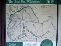
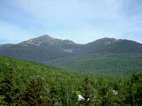
The Great Gulf Trail is considerably different than most of the popular trails up the east side of Mount Washington. It is often difficult to find solitude on many of the trails on the eastern side of Mount Washington, but not so on the Great Gulf Trail. This trail travels through a wild and untamable forest strewn with glacial boulders from the walls of this ravine. The trail also follows along a stream all the way to treeline and many beautiful cascades and flumes can be seen along the way. The best reason to take this trail is to have a true wilderness expereience on Mount Washington or en route to the other northern Presidential Peaks. And indeed, this area has been designated a Federally Protected wilderness area called the Great Gulf Wilderness. This trail is 7.5 miles long and gains 5000 vertical feet, so it is not for the faint of heart. Some people prefer to do it as a backpacking trip, while others choose to go do it as a dayhike. Know your own abilities before attempting this arduous and enduring trail.
Getting There
The trailhead is along NH route 16 about 2 miles north of the junction with the Mount Washington auto road.
Route Description
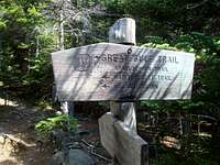
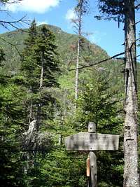
This route description presumes you will follow the Great Gulf Trail all the way to the summit of Mount Washington. However, you can consult of good trail map, and use this trail for many other options to other peaks in the northern Presidentials. Shortly beyond the trailhead, is a suspension bridge across the Peabody River. Cross this bridge and stay on the trail. Proceed along an easy trail, following along the west side of the Peabody River and eventually along the west side of the West Branch of the Peabody River. There are several junctions with ski trails in the first mile and a half. After about 1.6 miles, you enter the Great Gulf Wilderness Area, and shortly after that you will pass a junction for the Osgood Trail that goes up Mt. Madison on the right. In another half mile, you will pass a junction on the right for the Osgood Cutoff.
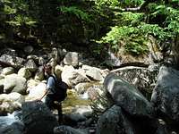
At all trail junctions follow the signs pointing to Mt. Washington and continue up the Great Gulf Trail. Very shortly after the Osgood Cutoff, you will cross a suspension bridge and then come to an area with some designated campsites and then you drop down and cross a second brook by rock hopping.

There are some views of the Great Gulf and the northern Presidentials from the trail in this area. The trail also junctions with the Madison Gulf Trail in this section. The trail begins to get rougher with lots of rock hopping and tree roots. At this point, you are on the left side of the West Branch of Peabody brook. In another mile, you will rock hop across Chandler Brook, and then junction with Chandler Brook trail on your left. The trail continues to get rougher, and after another 0.3 miles, you come to the junction with the Six Husbands Trail on the right and the Wamsutta Trail on the left.
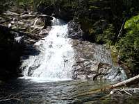
Continue on the Great Gulf trail as it follows along the left side the of the West Branch of the Peabody River with many beautigul waterfalls and cascades.


The Great Gulf also begins to narrow and you can see the sharp walls of Mt. Jefferson on your right. After a little more than a mile, you come to the junction with the Sphinx Trail on your right. After this junction, there will be several more interesting small stream crossings as you hike another mile to get the the very pretty Spaulding Lake.


It is on the right of the trail just before you get to treeline. From the lake, you can see the steep walls of the Great Gulf on almost every side of you. The lake is about 150 feet long and 50 feet wide and not much deeper than 2-3 feet. This is a nice place to eat some lunch and rest your legs and prepare for what lies ahead. You are already above 4,000 feet in elevation. The trail now ascends steeply up the talus slope on solid stable rock due south and little bit southeast.

You will gain about 2,000 vertical feet in the next mile. Watch for the blue or yellow blazes on the rocks and stay in the vicinity of the markings and cairns. The difficulty never really exceeds Class 2+.

There might be a few short sections where you want to use your hands, but overall, it is a very enjoyable section as the views of the surrounding area open up. Hiking from Spaulding Lake to the summit of Mt. Washington will take 1.5 to 2 hours depending on your speed.


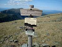
The ravine ends abruptly on the northern side of the summit cone of Mt. Washington. Take care to walk on the marked trail to the top of Mt. Washington in order to preserve the fragile alpine grasses and plants. Once you reach the top of the Great Gulf, you will cross the cog railroad tracks and follow the Gulfsife Trail 0.2 mile to the summit with all the throngs of people who drove up the road or took the train.

I guess it is true...The journey IS the destination!
Essential Gear
Standard summer hiking gear, including a waterproof jacket, and good footwear.
Red Tape
The White Mountain National Forest Charges $3.00 per day for parking at the Great Gulf Trailhead. You could also buy a 7-day pass for $7.00 or an annual White Mtn. National Forest Pass for $20.00.
Warning
Do not descend into the Great Gulf from Mt. Washington or the northern Presidentials during spring runoff or during periods of high water. You may descend only to find some water crossings impassable, and then your only option would be to re-ascend the ridges above treeline.
Also, the Great Gulf headwall is prone to avalanches in the winter months. It will be necessary for you to make your own judgments concerning snow stability when the Great gulf is snow-covered.
Useful Links
Trip Report and Description of a Great Gulf Hike
AlexeyD - Aug 14, 2009 1:17 pm - Hasn't voted
distanceHi, just thought I'd mention that as far as I know, the Great Gulf Wilderness boundary is more like 1.5 miles from the trailhead, not 2.5.