
|
|
Mountain/Rock |
|---|---|
|
|
38.11408°N / 119.79323°W |
|
|
Tuolumne |
|
|
Hiking, Scrambling |
|
|
Spring, Summer, Fall |
|
|
8359 ft / 2548 m |
|
|
Overview
Gillett Mountain is located near the southern boundary of the Emigrant Wilderness Area in the Sierra Nevada, a mile or so north of Lord Meadow and a half mile south of Big Lake and Yellowhammer Lake. Reaching the summit requires a long approach but a relatively easy class 3 scramble via the south face.
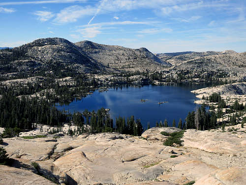
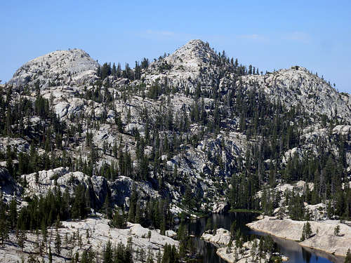
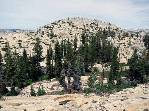
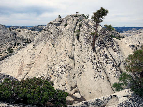
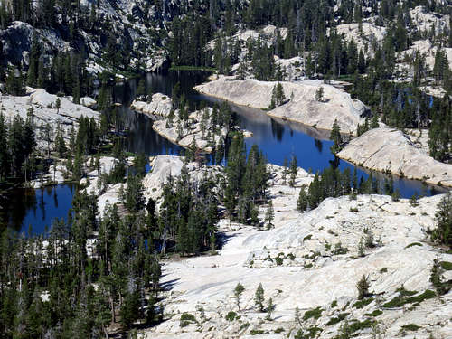
The peak is an eroded granitoid dome and otherwise not very remarkable but the surrounding area is quite scenic with an abundance of subalpine and alpine wildflowers, pine trees, lakes, and granite ridges. The EWA is best known as a backpacker destination; the trails are mostly well maintained and easy to navigate. Good camping and fishing at nearby Big Lake and Yellowhammer Lake make for a great multi-day outing!
|
|
Getting There
The 2 shortest approaches to Gillett Mountain are described below.
-
Starting from Crabtree Trailhead (~15 miles):
From Hwy 108 in Pinecrest: Head east on Pinecrest Lake Rd ~1/4 mile. Turn right on Dodge Ridge Rd and follow it for 3 miles. Turn left onto Crabtree Rd for 4.9 miles until you reach the trailhead and campground. Look for the trailhead parking signs.
From Crabtree Trailhead: Follow the trail south to Pine Valley and then take the trail split east towards Groundhog Meadow. Less than a mile further, take the trail split south to Rosasco Lake and continue on to Pingree Lake, Big Lake and then Yellowhammer Lake. From the southeast side of Yellowhammer, head south off-trail, ascend a small ridge, and then follow the drainage up and around the east side of Gillett Mountain until you reach the south face.
-
Starting from Cherry Lake / Shingle Springs Trailhead (~16.5 miles):
From Groveland: Travel east on Hwy 120 from Groveland about 13.8 miles. Turn left on Cherry Lake Road (Forest Road 1N07). Continue on Cherry Lake Road for approximately 23.5 miles to Cottonwood Road (Forest Road 1N04). Turn right (east) on FR-1N04 and drive acrosss the dam. At the east end of the dam, immediately turn right onto FR-1N14. After 1/4 mile, turn left on the unnamed dirt road to the northeast towards Shingle Springs. The road ends at a cement barrier where you can park.
From Tuolumne: Take Buchanan Road, which turns into Cottonwood Road (Forest Road 1N04). Travel approximately 30 miles to the Cherry Valley Campground sign. Continue past the campground and drive acrosss the dam on the southern end of the lake. At the east end of the dam, immediately turn right onto FR-1N14. After 1/4 mile, turn left on the unnamed dirt road to the northeast towards Shingle Springs. The road ends at a cement barrier where you can park.
From Shingle Springs Trailhead: Follow the Kibbie Ridge Trail north and east 15.1 miles all the way to Lord Meadow. About 150 ft north of where the Kibbie Ridge Trail fords the East Fork Cherry Creek, a low use trail splits off to the north following the North Fork Cherry Creek. Follow this trail a quarter of a mile or so and then pick the path of least resistence off-trail towards Gillett Mountain, which is roughly a mile and half north of Lord Meadow.
Routes
The north side of Gillett Mountain is not very friendly. It is steep and it has a lot of fallen trees, brush, and deep lateral ravines that require unpleasant bushwhacking to navigate.
The east, west and south sides can be climbed more easily.
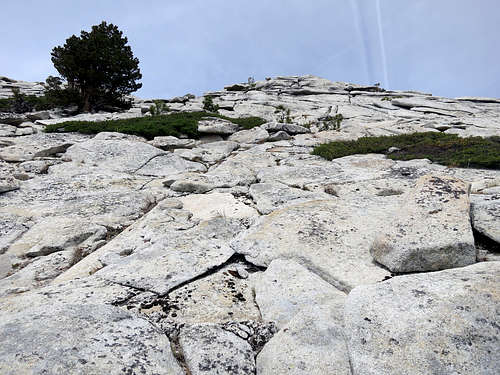
The easiest route to the summit seems to be the south slope, which is a relatively simple 15-minute class 3 scramble over mostly broken granite slabs and a few boulders. The (easy) class 3 section is near the top of the route just below the summit ridge. The hardest part of this climb is getting there!
|
|
|
Red Tape
Free wilderness permits are required for overnight stays in the Emigrant Wilderness Area and Yosemite National Park. Depending on your point of entry and which direction you are coming from, call one of the following ranger stations for wilderness permits.
- Groveland Ranger Station, for Cherry Lake Trailhead: (209) 962-7825
- Summit Ranger Station, for Sonora Pass trailheads: (209) 965-3434
- Bridgeport Ranger Station, for Sonora Pass trailheads: (760) 932-7070
Food Storage: Bear canisters are required by federal law in most areas of Yosemite National Park, however they are not currently required in the Emigrant Wilderness Area and the area around Gillett Mountain. Please check here for the current requirements as requirements change over time.
When to Climb
The climbing season varies each year depending on how much snow the area receives during the winter months, which impacts trailhead access. The distance of Gillett Mountain from the nearest trailhead adds complexity to winter climbing. So typically the most popular time to climb the mountain is from June through October.
Camping
There is good camping and fishing (Raibow Trout) at nearby Big Lake and Yellowhammer Lake. Panther Martin spinners work especially well in the Emigrant!
Current Conditions
Here are some links for local conditions.
Hwy 108 road conditions
Stanislaus National Forest conditions
You can also call the Summit ranger station for current conditions. They can be reached at (209) 965-3434.
Etymology
Gillett Mountain was named in 1909 by R. B. Marshall, U.S.G.S., for James Norris Gillett; member of Congress, 1903-1907; governor of California, 1907-1911.
-Place Names of the Sierra Nevada, by Francis P. Farquhar