
-
 7279 Hits
-
 74.92% Score
-
 5 Votes
|
|
Route |
|---|---|
|
|
46.38466°N / 13.92843°E |
|
|
Hiking |
|
|
Most of a day |
|
|
Hike up |
|
|
Rating the Route (By Hiking Standards)
Above Krma valley
The grading system for hiking and scrambling routes is here.
0. General: From cca 870 m to 2015 m, exposition NE and N. First a good hunters path, then a few narrow passages secured by cables. Above, an easy hike. Proposed is a bike & hike tour, meaning to return into Krma valley by a bike. Gear: Hiking gear, poles, a bike (can also be a normal one).
1. Effort: cca 1150 m, 3 h (then on the biking tour some 400 more meters of ascent).
2. Power: 2 - Easy.
3. Psyche: 2 - Easy.
4. Orientation: 3 - Medium (on biking).
Overview
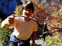
A stiff viper
Debela peč can be ascended in some 2 hours from the parking place on Pokljuka plateau. That's a nice tour, but here I'd like to propose something more: A nice northern approach (once this was a hunters path) over high rocky slopes on the panoramic summit, then an easy descent on the other side and a biking return back.
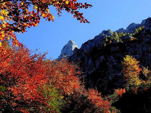
Krma valley is one of the three valleys, which penetrate deeply into the Triglav group. On the SE side, a long, rocky wall rises above it. From the first summit (Debela peč) till the last one Tošc, this wall hosts nice and also difficult climbs. Only on two places this wall is partly interrupted, so that in the distant past hunters could find passages over it. The first passage is close to Debela peč, is not secured and requires some easy climbing (would be nice to try it once). The second passage is today turned into a marked and secured mountain path, which brings you up on Lipanska vrata, the saddle between Lipanski vrh, 1965 m, and Brda, 2008 m. As it was done by metal workers from Jesenice, the path is now called Kovinarska pot.
Getting There & Logistics
In Krma valley
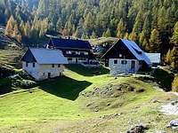
Drive with your car on Pokljuka plateau. On Mrzli studenec (crossroads) turn right on macadam road and drive by it till the end. On crossroads follow the 'Lipanca' inscriptions. The usual road passes Javornik alpine meadow on the northern side and finishes on a big parking place. If you know it, the other option could be the road, which goes more eastwards and brings you in the vicinity of Klek alpine meadow. The descent from Debela peč to Klek is even shorter. Leave on the final parking place yor bikes and drive by the main road down towards Bled, in Gorje turn left and drive through the beautiful Radovna valley till Zgornja Radovna settlement, there turn left again and drive into Krma Valley. Pass Kovinarska koča (hut) and drive some 1500 m more into the valley. There's the parking place, where you leave your car.
Route Description
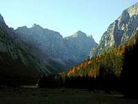
Views from the ascent route - Rjavina
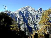
Just on the parking place above Kovinarska koča you will see a sign, directing you on Kovinarska pot - our ascent route. The path goes up in turns through the woods and soon approaches a distinct ravine. Then the path follows the slope left of the ravine and above crosses it. After crossing the ravine the path winds long time over the characterristic terrain - dwarf-pines, larches and steep, rocky steps. The path uses best passages and only a few steep and more exposed passages are secured by steel ropes. In the upper part the path turns more towards the right and passes below picturesque galleries. So it enters a ravine below Lipanska vrata. There it turns up and soon you reach the small saddle. To the right you can ascend Lipanski vrh, in the forward direction you can descend to Lipanca, but to the summit of Debela peč you must turn left. After a short steeper ascent, the path becomes much more flat, it crosses the slopes of Brda and in one hour from the saddle you reach the panoramic summit of Debela peč. Altogether 3 hours 30 minutes.
Lipanca meadow
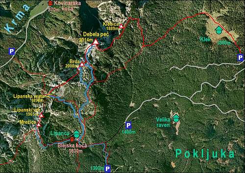
On the descent you will take the marked path of normal approach from Lipanca hut. Return from the summit of Debela peč till below Brda and on the crossroads there turn left down. A broad, marked path will bring you soon down to Lipanca meadow, from where you continue further (towards the south) on the parking place. (If descending towards Klek meadow, you must find the path from the summit of Debela peč towards the east. Only the last part is marked.)
Now the nice biking tour starts. You could of course go by the main road and bike through the whole Radovna valley, but you already saw that valley when driving around Debela peč with your car. So, you ride down only till the hunters hut in Planina Kranjska dolina, where you turn left. Now some more ascent is ahead of you. You ride northwards, then left towards Medvedova konta and right again towards Meji vrh. Allways hold on the stronger mountain road - for this part you need a map!
On the northern edge of Pokljuka plateau the mountain road slowly turns down towards Radovna valley. There from the left the Klek descent comes. You ride above the steep, rocky (and panoramic) slopes of Bratovlja peč and Rjava peč, then the road turns left and descends steeply into Stresena dolina. In many turns it goes fastly down, bike breaks are getting hotter and hotter, finally you hit the road in Srednja Radovna. There turn left and by the so nice biking road ride till Zgornja Radovna. Just before the settlement (a very good inn!) turn left again and ride into Krma valley. Till Kovinarska koča and further on to the parking place, you have some 200 meters of altitude to ride up.