
|
|
List |
|---|---|
|
|
Long Hard Days
Days in the mountains come in all shapes and size. Some hikes are a quick out'n back, the bag-your-peak-go-home style. Others require a little more effort and a longer day. And then there are those climbs. The ones that require all of your blood, sweat, tears…and then some! This page is for those battle stories, those adventure, those Mountains, Routes, and Rocks, a badge of honor for those who have achieved them and a warning to those who dare attempt them. Please let me know of any mountain, route or rock that fall into this category and maybe a link to a trip report if you have one!
The Mountains
 |
Peak G | Location: Colorado, United States, North America Elevation: 13260 ft / 4042 m |
Not high enough to be included in the "fourteeners", highest 100, or highest 200, Peak G is a seldom climbed peak. There are no guidebooks containing routes, there are no trails or cairned routes to the summit, and there is no name listed on any USGS map. These facts along with the challenge, the beauty of the mountain, and the spectacular view from the summit, beckon seasoned mountaineers to conquer its heights. |
 |
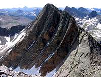
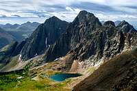
Mount Oso | Location: Colorado, United States, North America Elevation: 13684 ft / 4171 m |
Mt. Oso is perhaps Colorado's most obscure thirteener, and one of the most rugged and hard to reach. The mountain is well guarded by lesser peaks in height, but all of these peaks do not offer easy access or routes. This group of mountains, at times referred to as the Oso massif, is formidable in scope and scale. The approach and climbs are daunting propositions. |
 |
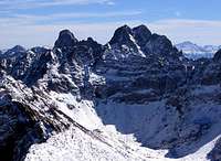
East/Middle/West Trinity | Location: Colorado, United States, North America Elevation: 13805 ft / 4208 m |
Named for obvious reasons, the peaks are most frequently climbed together, and they offer what Robert Ormes called "one of the finest scrambling traverses in the San Juans." The Trinities Traverse collects all three summits while testing your route-finding abilities. You'll be scrambling for hours, surrounded by beautiful terrain... does it get any better than this? |
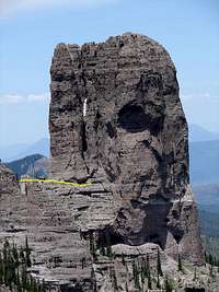 |
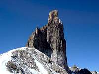
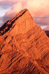
Chimney Rock | Location: Colorado, United States, North America Elevation: 11781 ft / 3591 m |
At 11,781 feet, this bastion of stone captures everyone's immediate attention, including those of movie producers. In True Grit, Chimney Rock served as a backdrop during Rooster Cogburn's (Wayne) unforgettable horse-riding, double-rifled-slinging match with reins in his teeth against three outlaws. No doubt the imagination of the ambitious technical climber is captured as well, yet very few take on the challenge. The towering Chimney Rock spire was first climbed in 1934 by Melvin Griffiths and Robert Ormes. The standard and only established route is rated 5.6 and follows the South Face Crack. Do not be fooled by the very moderate rating. Chimney Rock has dangers that make this peak a solid grade III climb. |
 |
Capitol Peak | Location: Colorado, United States, North America Elevation: 14130 ft / 4307 m |
Capitol Peak is regarded by many that climb it as Colorado's hardest fourteener. The mountain demands much of those who climb it. Experience is a plus, but determination and tenacity increase one's chances at success, not to mention very good weather. Any approach is long, the climb itself is equally long over countless rock obstacles above considerable exposure. Even when considering the many challenges Capitol Peak presents, it is without a doubt one of Colorado's most rewarding climbs. |
 |
Dallas Peak | Location: Colorado, United States, North America Elevation: 13809 ft / 4209 m |
Dallas Peak is not easily climbed, the easiest route is technical in nature, and it is strongly recommended that climbers either have extensive experience in technical ability and route finding skills or be led by a guide or someone that has climbed the mountain previously before attempting (see additional info below for links to some resources). Many consider Dallas Peak to be one of, if not the most difficult of Colorado's high thirteeners to climb. |
 |
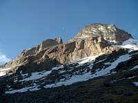
Vestal Peak | Location: Colorado, United States, North America Elevation: 13864 ft / 4226 m |
Vestal Peak is interesting primarily because of its north face/buttress - known as Wham Ridge. Wham Ridge must be seen to be believed. With careful route-finding, it can be climbed as an approx. 1500' 4th class rock climb, with short low fifth class passages. Most parties will however, find a rope and a small rack comforting. |
 |
Storm King Peak | Location: Colorado, United States, North America Elevation: 13752 ft / 4192 m |
Storm King Peak is a rugged, majestic, and beautiful peak hidden in a remote region of the Grenadier subrange of Colorado's San Juan Mountains. Like its neighbors, its quartzite north face thrusts skyward in dramatic fashion offering at least one 1500 ft. 15 pitch 5.7 route for the technical climber. The south side offers the non-technical climber a 2nd and 3rd class scramble. |
 |
Lizard Head | Location: Colorado, United States, North America Elevation: 13113 ft / 3997 m |
Lizard Head ... is the most difficult of Colorado summits to reach. In fact the rottenness of its 400' tower makes safety too much a matter of luck for comfort. Returning visitors have formed the opinion that the peak has become noticeably rottener and more dangerous. Our advice ... when you reach the base, take [a] picture and go home. ...Robert Ormes in the Guide to the Colorado Mountains, Seventh Edition, 1979. |
 |
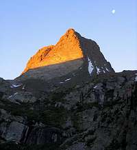
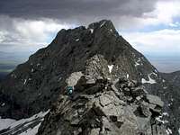
Jagged Mountain | Location: Colorado, United States, North America Elevation: 13824 ft / 4214 m |
Jagged Mountain lies in the heart of Colorado's remote Weminuche Wilderness Area of the San Juans. It is the 94 th highest peak in Colorado and provides one of the most difficult standard routes on a large peak. Jagged is not easliy viewed by anyone other than those willing to get off the road and start hiking. The true summit was not reached until 1933. |
 |
Outlaw Peak | Location: Colorado, United States, North America Elevation: 6489 ft / 1978 m |
So, do you like really remote peaks and territory? This is a really nice surprise. Northwestern Colorado, without question, has the most remote peaks in Colorado and almost certainly even has some un-climbed peaks. These peaks are incredibly spectacular and almost completely ignored. |
 |
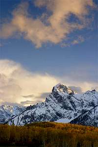
Longs Peak | Location: Colorado, United States, North America Elevation: 14259 ft / 4346 m |
Like the name implies everything on this mountain is a heck of a climb. Expect a long day and some sort of adventure. |
 |
Crestone Needle | Location: Colorado, United States, North America Elevation: 14197 ft / 4327 m |
There is no short approach unless you can drive up ones of Colorado's worst roads, otherwise expect 5,000 vertical feet of elevation gain and roundtrips between 15-20 miles. |
 |
Crestone Peak | Location: Colorado, United States, North America Elevation: 14294 ft / 4357 m |
There is no short approach unless you can drive up ones of Colorado's worst roads, otherwise expect 5,000 vertical feet of elevation gain and roundtrips between 15-20 miles. |
 |
Kit Carson | Location: Colorado, United States, North America Elevation: 14165 ft / 4317 m |
"Begins at 8,500 feet +/- and ascends steeply on well-groomed trails. (about 5,700 feet of vertical change from trail head to Kit Carson summit). I am not sure of the exact round trip mileage, but it can be done in a day, no camping, in about 14 hours + / -" |
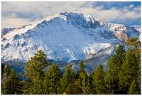 |
Pikes Peak | Location: Colorado, United States, North America Elevation: 14110 ft / 4301 m |
I don't care what anyone says...25+ MILES IS A LONG WAY!!! |
The Routes
 |
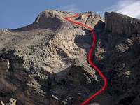
Little Bear/Blanca Traverse | Mountain: Little Bear & Blanca Peak Difficulty: Class 5.0-5.2 Route Type: Scramble/Rock Climbing |
The traverse between Little Bear and Blanca is one of Colorado's four great fourteener traverses. Some say it is the most difficult of the four. The traverse is about 1 mile and takes between 2-8 hours to complete. |
 |
Keplinger's Couloir | Mountain: Longs Peak Difficulty: Class 3 Route Type: Bushwhack, Moderate Snow Climb, or loose scree-filled summer climb |
A long approach to Longs south side filled with bushwhacking. Requires a backpack trip. |
 |
Harvard/Columbia Traverse | Mountain: Mount Harvard & Columbia Difficulty: Class 2 Route Type: Hike/Scramble |
On this route you will almost completely circle Mt. Columbia. At 14 miles round trip, with lots of vertical gain, it will also wear you out. Start early. |
The Rocks
Please let me know of worthy rocks!