Onto Borah, the roof of Idaho
NOTE: My picture server deleted my pics. I will add the ones below noted as Fototime ASAP. I forgot to pay the monthly charge and before I got my check to them, they deleted all my albums, which was a bad thing since I had linked many of the pics to my trip reports as you can see here (below). My apologies When I get the pics up again, I will delete this part. Working on getting the pics back up as of 9-3-13
On thursday morning, I awakened early because I had this "inspiration" come to me that
Borah Peak was the peak I was going to climb. When I had gone to bed, I was clueless about what I was going to chase after for the weekend and I was entertaining heading for the Cascades to do either Mt. Aix or Three Fingers, both peaks that I had my eyes on.
I was surprised that it was Borah Peak that I felt 'inspired" to go after because
Bob Bolton and I had just made the long trek to eastern Idaho to do several peaks in that area that included Hyndman Peak. Bob had already climbed Borah and he had no interest in it a second time and was much more interested in doing Hyndman Peak. Hyndman turned out to be a terrific choice and I really enjoyed doing that one. However, I would have loved to have had a chance for Borah but that wasn't in the cards for that trip.
I quickly checked the computer for weather reports and was happy to see that really good weather was forecast for the area. Normally on a thursday I'd be at work but for some reason I had this particular thursday off. I informed my wife of my decision to head for eastern Idaho once again and asked if she wanted to go with me. She gave me that "are you crazy" look and I had my answer. I put my gear together, did some yardwork that I had promised to do and by noon I was on my way. NIne hours later, I found myself at the TH for Borah Peak although along with about 12 others who were already camped there.
A bit before 6 a.m. I started up the trail which was easy to follow, even with minimal lighting thanks to a big full moon that helped to illuminate everything. I won't go into a trail description since other trip reports have done a great job of providing it so I'd recommend reading some of the other great trip reports posted here for Borah.
At the point where the forest ends, there is a nice campsite and a spot to rest and I took the time to call a break for some nourishment and hydration. Three guys passed my spot about five minutes after I had settled in and I found out that they were from Seattle. The summit log listed them as Tom, Paul and Steve. They were all carrying ice axes which turned out to be unnecessary since there were no snow fields to deal with higher up. After they passed by, two others came up a few minutes later and I got to meet Bob (yup, another Bob only this one was from Boise) and Paul (from Pittsburg) In talking with the two of them, I found out that Bob had done Borah once before.
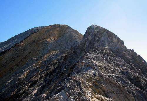
The first view of Chicken Out Ridge and Borah Peak from the trail
With my rest break over, I started up the hill that finally connects to the ridgeline walk that eventually leads you to Chicken Out Ridge
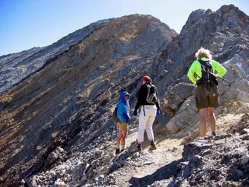
(COR). I had passed Bob and Paul while they were taking a break and I took my last break just below COR while I watched the Seattle guys take their route up it. Bob and Paul caught up with me while I sat there soaking in the scenery and some more food and water. During the few minutes we spent chatting with each other, two women caught up with us and soon there were 5 of us ready to start up COR. Since Bob had previous experience with the ridge, we all quickly said we'd follow his lead (slam dunk thinking). It was at the first sketchy move where Paul decided he wanted no part of it. The two women expressed concern but Bob was quick to encourage them and offer advice. The women were real go getters (ages 56 and 52) and they took Bob's directions and soon were across the sketchy spot. From there we all made our way along the right side of COR for a bit and then shifted over the left and traversed a bit before going up a chimney like gully which led us to the so called "crux" of COR, a 20 foot downclimb. Bob helped the women again and soon we were all down to the saddle, which at this time of the year has no snow. While the women were dealing with the downclimb, a group of 4 others showed up and had to wait a bit as the women sorted out the correct moves on the class 3 downclimb. While slow, they did great particularly since neither one had ever dealt with this type of stuff.
![My 3 new trail companions]()
A decent trail of sorts follows the west side of the remaining ridge and leads to a final saddle where we met some of the early morning climbers that had started up before us. They were resting after their summit and gave us a big thumbs up as we went by. The trail then went right to work. Straight up and at times it was easy to lose. Still, every time I lost the trail, I would find it or another one that did the same job. I eventually found that the best way to gain elevation was to find places where I could grip some rock on one side and plant a trekking pole in the scree on the other. Once I started doing that, my upward progress improved. Bob was still giving pointers to the two intrepid women who turned out to be grandmothers in their fifties from a small Idaho community who thought getting to the top of Idaho would be pretty neat. They wondered why no one else in their social group was even mildly interested in seeing what the top of Idaho looked like and their husbands kept questioning their sanity.
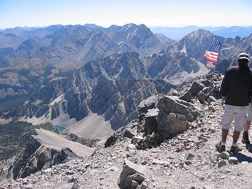
The three climbers from Seattle passed me on their way down and said I had less than 20 minutes to go to the summit. I offered my congrat's to my fellow Washingtonian's and they offered me a pre summit congratulation since I was almost there. Before long, I could hear the flapping of the summit flag and waiting there to offer congratulations were Bob and the two amazing grandmothers who had summitted a few minutes before me. I had stopped a number of times to take pictures and they saved me a spot on the summit. I signed the register that was kept in an ammo box, or should I say, I signed a sheet of paper since the ammo box is filled with filled booklets, slips of paper and other odds and ends. Overall, it was an unorganized mess. Someone needs to take a decent mid sized notebook up there. I grabbed a drink, shot some pics and called my wife, & got ready to head back down. I did my best to soak in the view and off to the east I could see both Bell and Diamond Peaks, both on my tick list for a future trip into that part of Idaho. Plus I have unfinished business in Clark county to take care of.

The crowded summit on August 19th
The trip down went fairly slowly (slower than I thought it would) as we had to watch our step, every step. After screwing up a knee on the talus of a peak in Nevada last October, I may be a little more cautious than need be for the moment. Reversing COR was no problem and Bob found a neat solution to the sketchy step over that we had begun the ridge with earlier that day. We met up with Paul who had waited for his friend to return and snapped a picture of the four of us. (Bob and the two fantastic grannies and myself) and down down down down down we went. That stretch where the trail enters the trees is a real pain, hard on the knees and your butt if you misjudge. However, at least it is only a mere 2000 feet of down.

Bob finds the way back down Chicken Out Ridge
The weather remained perfect all day and the wind was generally not much more than a breeze. I had a day just like it on Mt. Whitney two weeks before and I keep pinching myself to see if getting weather like that isn't a dream come true. I'll happily take it.
Don't underestimate this mountain, I certainly did. I thought it would be easier than it was but I feel you will feel a great sense of accomplishment when you check it off your completion list. It is a work out so start early in the morning, carry plenty of water and sunscreen and watch the weather since things could change quickly up there. Don't let COR keep you from doing it, those two grandmothers proved to me that most people can do it. It is easier than it looks. I felt bad for Paul because he made a huge effort of gaining 4000 feet and then let that spot keep him from going further. Still, I won't judge and say that he should or shouldn't have tried it if his inner self was screaming NO at him. Each of us has to hike his own hike. Paul can pat himself on the back for a heckofa effort just to get to COR.
Time up: I'm slow and I 'm old so you can't tell much from my time but it was just under 6 hours (hiking time) Down? About 4 hours. Granted that is slower than most but I am always happy to summit and get down safely. I may be a little more cautious nowadays after
screwing up a knee and breaking a hand last year but as the saying goes "summiting is optional, getting down is mandatory".
I now have the state highpoints of Tennessee, Washington, Oregon, California, Nevada and Idaho. My next goal is Kings Peak in Utah. Stay tuned.
---------------------------------------------------------------------------------------------
Some Borah Peak tidbits:
Borah is Idaho's tallest mountain at 12,662 feet.
It is the
county highpoint of Custer county and one of the sought after
State Highpoints
The elevation gain from the TH parking lot to the summit is 5412 feet according to the book "Trails of Eastern Idaho" which has a special section dedicated to each of Idaho's 12,000 foot peaks.
Most guidebooks and trip reports claim that the round trip is 7 miles but the book I quoted from above says it is 9.2 miles round trip now which I thought was interesting. Maybe it just seems longer but the 9.2 may be overstated. The book also says time expected can be from 6 to 12 hours, depending on age and conditioning. It took me ten hours and could just as easily gone faster or slower. I enjoy a slower pace than most people because I am slower but then maybe I can blame it on being 65 years old and getting back into shape after recovery from a knee problem. I think most people would be in the 8 or 9 hour range, depending on how fast you want to take the downhill part. Perhaps 4 1/2 hours up and 3 1/2hrs down. The speed record according to authors Margaret Fuller and Jerry Painter is an incredible 90 minutes. It has been climbed in every month of the year and was named after an early Idaho Senator named Borah. A few people have died on Mt. Borah but surprisingly few. Two fatalities were early season climbers caught in an avalanche and another was a glissader who shot off of a cliff to his death. I've read many reports of broken ankles and other injuries but since there are generally a lot of great people on this peak, those with the nasty injuries have had helping hands to assist them. But if you decide to do this peak solo on a weekday, let someone know where you are and give them some check on you times. I had cell coverage on the summit and one of the ladies got a call on hers part way down from the summit but after that, don't count on it. Getting caught in an electrical storm high on the mountain would be a scary experience
and ice or snow on COR would make what is pretty easy, a bit more difficult so stay in tune with the weather and changine conditions and act accordingly.
One last pic from the Borah experience. Looking southeast from the summit I could see a lake far below and waves of gorgeous peaks.
Idaho is truly a treasure.


Comments
Post a Comment