Setting the stage
I figured that if I could just make it to Anderson Pass, I'd be able to get the rest of this effort done. Afterall, Kings Peak was the reason I was here and might be the high point of my whole summer for 2006. I had been working on the western state highpoints and was only two peaks away from finishing off the Utah county highpoints as well and so I really needed to gut this out and get it done. However, I was beginning to feel like a climber on Everest whose oxygen had just run out, each step up towards the pass was getting tougher and tougher. I could look up and see Dennis sitting there and even from where I was on the trail, I could tell he was wondering what my problem was. After all, the peak was less than a mile away and not even a thousand feet higher but it might as well have been on the moon the way I was feeling. Perhaps it was the week catching up with me or maybe my lungs just couldn't get the oxygen they needed after the bout with pneumonia earlier in the year but here I was, struggling to put one foot in front of the other and the pass was still a long ways away. Rats....
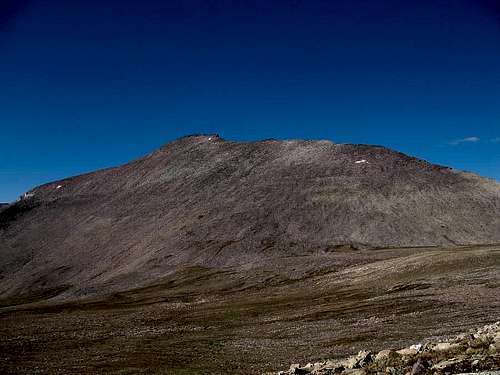
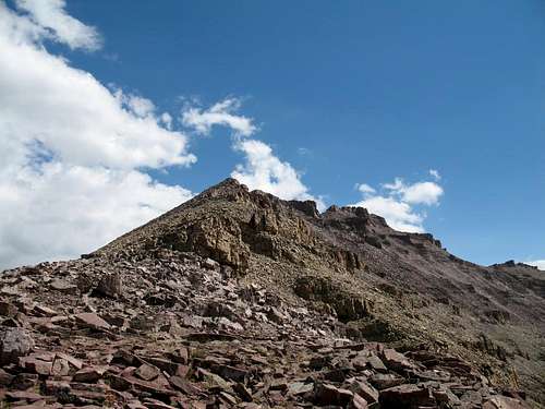
![Anderson Pass]() Anderson Pass
Anderson Pass
I was bonking and my mental side wasn't winning with its fight to make the physical side of me work hard enough to go much further. Leaden legs and frustration were beginning to plague me as I wasn't really one to quit so close to a goal but here I was, just wanting to sit down and come back another day when I would be in better form. Finally I pulled into the pass at the speed of a turtle and told Dennis to go on, I was done for the day. Rats....
Have you ever got to within sight of your goal and just totally run out of gas and couldn't go any further? Well, I was whipped and so after a short break I started back down....but first, here is the rest of the story.
The previous week
I had been in Idaho, Utah and Wyoming a week already, having a great time with my son earlier in the week and Dennis more recently. I had left Kennewick on August 14th and had picked off an Idaho prominence peak by mid afternoon when I visited the lookout atop
Harrison Peak. The next day, August 15th, I visited the Idaho county highpoint of
Franklin county and later the same day the county highpoint of Weber county Utah,
Willard Peak. I finished the day by staying at my son's place in Sandy Utah and then he and I drove down and did the county highpoints of
Iron and
Kane county on August 16th before heading to a campground where we spent the night prior to doing Utah's Washington county highpoint,
Signal mountain on the 17th. Signal was a tough hike, not technical, but tough with a 4400 foot elevation gain overall in a 11 mile round tripper.
![Brian Head Peak]() Iron county highpoint
Iron county highpoint
After Signal Peak, it was on to sight see
Bryce canyon on the 18th and then after being tourons for most of the day, we drove north to pick off
Mount Dutton , another Utah prominence peak which took us into an area where the forest had burned badly the year before and the forest service was still clearing downed trees and trying to repair destroyed bridges as we drove in from the south but that is another story and might be worth a trip report of its own some day. So it was back towards the Salt Lake area where we pulled in very late at night (near midnight) and I spent another night on my sleeping pad on the floor in my son's spare room.
The next morning I had a chance to have breakfast with
Bob Bolton and his wife Rhonda who were headed south to do some stuff in Utah and Arizona. What a fun meeting that was because the timing was such that we were in the same area at the same time as they were going one direction and I another. While having breakfast with the Bolton's, my phone rang and it was
Dennis who had just done Willard Peak of Weber county the day before and who was now going to accompany me for the rest of the week as we planned to finish up the county highpoints of Utah together as well as Kings Peak. Dennis was at the parking lot near the mouth of Big and Little Cottonwood canyons which was only about twelve miles from where we were having breakfast so I left Bob and Rhonda to their journey and drove up to meet Dennis. Dennis and I went drove up to Snowbird and had a successful summit of the highpoint of Salt Lake county,
AF Twins before we headed for Wyoming and found a place to sleep in our trucks off of I-80 where we spent the night of the 19th, listening to the semis roar by all night on nearby I-80.
![West Twin]() Salt Lake county highpoint
Salt Lake county highpoint
What a great life, nothing beats the freedom of the open road in the western USA.
Up to Dollar Lake
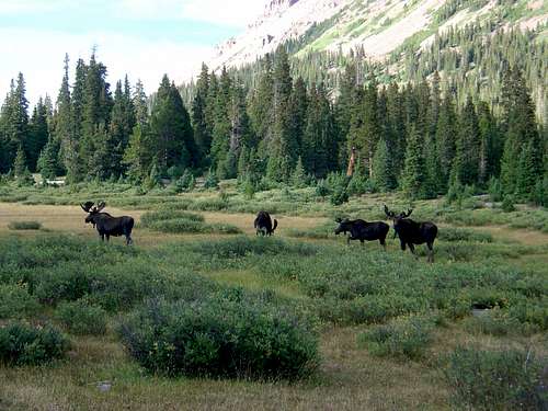
![Gilbert]() Dollar Lake Moose
Dollar Lake Moose
Morning found us driving over 200 miles to pick up the county highpoint of Sweetwater county,
Pine Mountain, located in the true middle of nowhere but that is another story all in itself. After our successful foray to Sweetwater county, we headed back to Rock Springs where we had a not so delicious hamburger at the local Sonic fast food place there. Then it was onto to Henry's Fork and we spent the late afternoon of August 20th, backpacking into
Dollar Lake, 8 miles from Henry's fork, arriving at the lake in the dark and setting up camp for the next two days. On the way in, we had to dodge two moose who were not overly anxious to share the trail with us.
We chose Dollar Lake as our camp area because it would allow us to not only pick up Kings Peak but also nearby
Gilbert peak, the peak that Dennis and I would finish the state of Utah's county highpoints on. Both Dennis and I squeezed into my REI quarterdome and despite the minimal space, we slept surprisingly well. Dollar Lake sits at an elevation of over ten thousand feet so the next morning I knew it would be a full day for me as the week was beginning to catch up with me since every day for a week I had been on the move. I figured though that a week at Utah's elevations would help my acclimatization and for the most part I'm sure that happened. The problem of me being out a week is that I'd had a bunch of nights where I didn't get the greatest sleep and my nutritional intake was probably less than ideal. Perhaps that affected
me but then who hasn't experienced the same stuff without it stopping them from accomplishing their goals.
Kirt Davis's nice shot of the moose near our camp
The climb
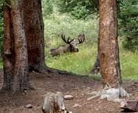
The next morning Dennis and I were up and going at 7 a.m. and made our way up the trail towards Gunsight Pass, which at 11,888 feet is 1100 feet higher than where we camped. On the way to the pass, we found ourselves passing between two full antlered moose, one on each side of the trail. Yikes. I didn't even see them until it was too late but then I hike with my head down, looking at the trail and for money that has fallen out of the pockets of previous hikers. As the trail zigzagged up towards Gunsight Pass, I noted another hiker ahead of Dennis and I on the trail. That hiker would later play a big part in my day but I'll save that tidbit for later.
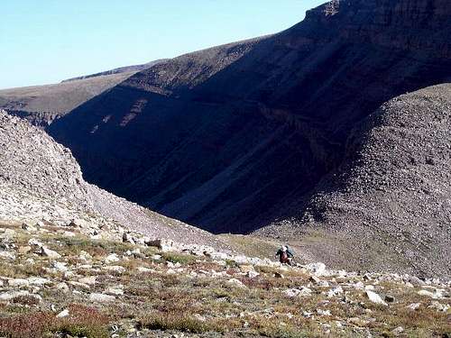
Dennis was ahead of me, arriving at the pass about five minutes earlier and had been studying the map and route description so when I caught up with him, he already had the way ahead figured out. We could see the other hiker ahead of us descending into Painter Basin but that wasn't the way we were going to go. We took the climber's shortcut which left Gunsight Pass and cut off a couple miles of hiking plus the gain and loss of well over hundreds of feet, IMHO, the only way to go. We found it an easy way to go and should I have it to do over again, I'd go the same way.
Working my way up the shortcut wasn't a problem and I was feeling pretty good. However, then when we finally got back onto the trail about
HERE, I
started to feel lousy and I could feel my energy ebbing. I always hike slowly uphill (ask anyone who hikes with me) but then I had a lower gear that I normally never need. Afterall, just a year before I had dayhiked Mt. Whitney and felt good all day long which entails a hike of over 22 miles and 6000 feet of elevation gain and I had no problems with keeping a good pace all day, but here, I was starting to get leaden legs. Dennis moved out ahead of me and soon was a good ten minutes ahead of me.
All I could think of was that the elevation was affecting me, that perhaps the pneumonia I had, had messed up my lungs somehow and I wasn't getting the oxygen I needed. Yet, the elevation hadn't bothered me earlier in the year on Humphries Peak in Arizona, so I most likely was suffering from poor nutrition and maybe even dehydration. I wouldn't even consider that perhaps it was my age catching up with me, or that perhaps this was just an off day. Whatever it was, I had leaden legs and my will to reach my goal was fading.
![Kings Peak]()
When I finally reached Anderson Pass where Dennis was waiting, I told him to go on, that I was done and had nothing left to push on with. He tried to talk sense to me and did his best to encourage me but I really didnt' want to keep him from making the common goal we both had (pretty noble huh?) and the weather was famous in this mountain range for quickly going south. With Dennis's speed, he could easily summit and get back down. Finally Dennis knew he couldn't get me to keep going so he headed up, looking back once in a while to see if I had changed my mind.
Totally beaten, I sat down on a rock and began to eat some of the food I had carried in my daypack. I also began to drink some water, something I had neglected to do even though I know better. At least fortified with the food and water, I headed down the zigzaggy trail to its base where I once again stopped myself and pulled out the feed bag and more water. Then I noticed this guy coming up the trail, the guy I had seen earlier who had descended down to Painter Basin. Just before he got to me, two guys and a dog went hustling by, moving at that hyper speed that youth can allow you to move at. They asked me if I had summitted and I said no and that I was going down.
The guy coming up the trail was about ten years younger than me, but it looked like he was a bit beaten himself. But he was determined to summit the mountain. When he reached my resting spot, we had a chance to chat a bit before he moved on and it turned out he was a retired optometrist named Vern who was after the USA state highpoints and was determined to get to the top of Kings Peak. His determination was infectious and as we talked, I felt my energy levels beginning to return and began to reconsider my decision. He moved on up the trail and then I felt my common sense returning and a bit of competitiveness. Vern wasn't going to beat me to the top, no way nor was I going to go down without getting this peak done. I grabbed my pack and headed back up towards Anderson Pass, 300 feet above me. I caught him and the two young guys at the Pass and they looked surprised to see me since I had been heading down when we had met. I was no longer that beaten old guy they had encountered but a new younger person full of determination to do what I had come to do and that was to stand atop Kings Peak, Utah's highest spot. Let the games begin....
Fortunately, I had caught my second wind, most likely due to the food and drink I had forced upon myself. I always have to remember to eat something on a hike but in this case it turned out to be providential that I did. Then Vern asked if I would stay with him as he was feeling a bit of trepidation about the route up and I agreed to do so. About two hundred feet above Anderson Pass, Dennis suddenly appeared on his way down and he was surprised when he saw that I was headed up. Dennis had already been successful but he decided that he needed more punishment and elected to join me on my summit effort which was a great gesture on his part (the mark of a real friend) and his knowledge of the way up was helpful, very helpful. The route up from Anderson Pass to the summit is mainly through jumbled blocks of talus and although it is obvious as to the way you need to head, picking the easiest way was easier thanks to Dennis's knowledge of the route. There is nothing technical at this time of year but the biggest concern is how quick a storm can appear and lightning is something we all should have a healthy respect for. Clouds were beginning to form so the faster we got to the summit the better. As we made our way upward, it wasn't long before Vern started lagging behind. He definitely was slower than I was and I kept stopping to see how he was doing. After awhile he just waved me on to keep going and as it turned out, he ended up being about 15 minutes behind when I got to the summit. Just below the summit, the two guys and the dog were just starting back down, the dog looking very fresh considering some of the rock hopping that he would have been forced to do on the way up. Maybe he was just happy to be going down. Dennis and I highfived on the highest spot in Utah and I was particularly relieved to have been able to get this one after my poor performance earlier. Now only Gilbert Peak remained, the third highest peak in Utah for both Dennis and I to complete Utah together.
We had no sooner finished taking some pics when a dad and his three teenage daughters made their appearance. They were from the Salt Lake area and for the girls, this was their first major high mountain effort. Pretty good considering they had come up the infamous chute (aka toilet bowl) and didn't follow the regular route up (such as it is). Also, Vern made his appearance and he was overjoyed to get to the top of Kings, his third or fourth state highpoint on his trip. I was happy for him as he had a gritty
determination and there was no quit in this gentle guy who was planning to go do Borah next. If I remember correctly, he was from Georgia and was retired from the military. The weather was a real big concern but first I wanted to go get the geocache that was located near by. Well hidden in the rocks away from the summit since the wilderness area doesn't allow registers or plaques honoring the man the peak was named after to "mar" the pristine beauty. While Dennis was talking with another guy who had a map question I made my way over to grab a geo cache but since the weather was getting scary, I just did a touch and go and headed back for Dennis since he was ready to get the heck out of dodge. We had to get down, as quickly as we could. About halfway down to Anderson Pass, the storm hit and lightning and thunder roared nearby. A few climbers from Texas on their way up to the summit hunkered down to wait out the storm, which fortunately passed over in about fifteen minutes. No lightning strikes hit near us but with an electrical storm, one never knows. I remembered
a story by SP member
Scott Surgent who had an amazing experience as he descended from the summit as an electrical storm came out of nowhere to make his climb an unforgettable experience.
The toilet bowl out
As we finally reached Anderson Pass, we watched the father and his three daughters head for the toilet bowl. Hmmmmm, maybe we'd give that a go instead of going back down the shortcut from Gunsight Pass and so we decided to give it a go.
Dennis was the first to reach the rim which overlooked the chute and tentatively made his way down a bit to get a better look at whatlay below.
I held up so I wouldn't kick any rocks down his way and as I waited Vern caught up with me and we watched Dennis go down further and further until he was out of sight. It was now my turn and I started down, sometimes making a controlled step or two and sometimes skidding down out of control. Thank goodness for hiking poles, they really help on terrain like this where everything is unstable and moves.
![Kings Peak]()
I had taken a knee out a couple years earlier and had undergone physical therapy so I am now over cautious on stuff like that but before long I found a rythymm and I was making my way down at a slow but steady pace. A couple rocks came bouncing down past me and I looked up to see Vern above me. I waved at him to get to one side or the other of me and he figured out what I was trying to communicate. For awhile, he stopped moving so I could get safely out of rock range and then he moved off to one side to continue his descent. About the time I was halfway down this chaotic mess, I could see that Dennis was nearly down to the flatland below. Probably a half hour after he had found the bottom of the chute, I joined up with him as he was filtering some water from a small pond. We looked back up the slope and could see Vern at about the half way mark cautiously making his descent. We waved at each other and Dennis and I headed for camp. The hike back to Dollar Lake seemed to be longer than I expected it to be but it gave me a lot of time to reflect on how the day had gone. I was proud of myself for not quitting, even after I had pretty much hit the wall the initial time I got to Anderson Pass but the timing of Vern who was slower than me showing up about the time I was heading down, was enough to get me re-loaded and heading back up to do what I knew I was capable of. I learned some lessons about eating and keeping hydrated, despite the fact that I thought I already knew all that. Sometimes we get humbled in strange ways but I am very thankful for a trail angel named Vern
![Down the toilet bowl]()
Our campsite at Dollar Lake looked like the Taj Mahal after a very long and for me trying day but a good freeze dried dinner and lots of water plus the local moose show (4 of them were nearby), we slept well as we dreamed of finishing off Utah on another 13,000 foot peak the next day.
Hitting the wall or bonking
When Eric (see comments) brought up the thoughts on the meaning of "bonking" as used in this report, it was time to check out Wikipedia for an in depth analysis of the word. Here is the
Wikipedia information:
Bonk (condition)
From Wikipedia, the free encyclopedia
Bonk has long been a colloquial term, slightly jocular in its connotation, and originally oriented to sexual, but
has recently become more commonly used as a jargon term by endurance athletes, primarily cyclists and long-distance runners, to describe a condition when the athlete suddenly loses energy and fatigue sets in, usually caused when glycogen stores in the liver and muscles are depleted, resulting in a major performance drop.
The term can be used both as a noun ("hitting the bonk") and a verb ("to bonk halfway through the race").
This condition is also known to long-distance (marathon) runners, who usually refer to it as "hitting the wall". It is also referred to as the "green grass" as pupil dilation causes vivid hues to appear. Such fatigue can become seriously debilitating; for example in cycling, due to the support provided by the bicycle, exhaustion can reach the point where the cyclist is unable to stand.
Whenever athletes are engaged in exercise over a long period of time, their bodies produces energy via two mechanisms:
* via fat metabolism and
* via breakdown of glycogen into glucose, followed by glycolysis.
How much energy comes from either source depends on the intensity of the exercise. During intense exercise which approaches one's VO2 max, most of the energy required comes from glycogen.
The average human body usually stores enough glycogen to generate 1500 to 2000 kcal of energy. Intense cycling or running can easily consume 600-800 or more kcal per hour. Unless glycogen stores are replenished during exercise, after 2 hours of continuous cycling or 15 to 20 miles (24 to 32 km) of running, glycogen stores will be depleted. Symptoms of depletion include general weakness, fatigue, and manifestations of hypoglycemia, such as dizziness and even hallucinations. Symptoms will not be relieved by short periods of rest. This condition is potentially dangerous and should be avoided.
There are several approaches to prevent glycogen depletion:
1. Carbohydrate loading is used to ensure that the initial glycogen levels are maximized, thus prolonging the exercise. This technique amounts to increasing complex carbohydrate intake during the last few days before the event.
2. Consuming food or drinks containing carbohydrates during the exercise. This is an absolute must for very long distances; it's estimated that Tour de France competitors receive up to 50% of their daily caloric intake from on-the-bike supplements.
3. Lowering the intensity of the exercise to the so-called 'fat loss' level (heart rate of 130 bpm for a 30-year-old athlete) will lower both the energy requirements per unit of distance and the fraction of the energy that comes from glycogen.
--------------------------------------------------------
One other source that describes the meaning of the word Bonk can
be found
HERE (click).
So there you have it, the meaning of the word "BONK"
--------------------------------------------------------
Ed Viesteurs in his new book
"No Shortcuts to the top" mentioned bonking on page 191. Yes, he used it in reference to hitting the wall during some
VO2 tests he was undergoing.
Postscript &A few more pics
The next day after we had climbed Kings Peak, Dennis and I finished off the state of Utah by climbing up Gilbert Peak and that story is contained in this
TRIP REPORT.
![Gilbert Pk as seen from Kings]() Gilbert from Kings
Gilbert from Kings
It was interesting to see that the summit plaque that once was on the summit of Kings Peak was no longer there and only some cement marks
![Yours truly and Duane on the...]() Summit plaque
Summit plaqueindicated where it had been placed. I was told that the forest service doesn't tolerate such signs in a wilderness area but I was amused by all the domestic type sheep we had to dodge on the trail back down from Dollar Lake (no moose this time) and wondered about such a double standard.
I've had a lot of time to think about what I experienced on Kings and how I nearly quit and walked back down the trail, knowing full well that I would have to come back and complete what I would have left unfinished. I know now in retrospect that it was poor nutritional intake from not getting any dinner when we got into camp at Dollar Lake and then failing to have any kind of a decent breakfast (one energy breakfast bar) darn near cost me the summit. Since then I have made mental notes to remind myself to never take those for granted again. Basic stuff I know, but sometimes neglected and treated lightly as we are in a hurry to get moving and thus become vulnerable to running out of energy when you need it the most.
I had helped a guy on Mt. Whitney the year before who had bonked about a mile from Whitney's summit and had wondered how he could get himself into that situation. Now I know and I've been humbled by it. I now carry a lot of GU packets with me as well as some decent food and a hydration bladder that is full to the brim before I hit the trail. I also throw in a quart of Gatorade or similar type drink. My plans for next year are such that I will not opt for a repeat of my Kings Peak performance. Who says you can't teach an old dog new tricks.
Update as of Dec 5, 2016: I have discovered that two of the three climbers we celebrated our Utah COHP completion on Gilbert with had signed the geocache on Kings Peak a bit earlier in the day. As of today, with a year of intense geocaching activity, I am enjoying this GPS driven hobby and I'd like to encourage others to not trash or disrespect a geo cache if you find one on or near a mountain summit. Please leave it be and take a moment when you have a chance to visit geocaching.com to learn more about this really fun activity.
![Uinta beauty]() SE of Kings Peak
SE of Kings Peak![Kings Peak weather]() Weather always a concern
Weather always a concern )


Comments
Post a Comment