
-
 8601 Hits
-
 84.82% Score
-
 19 Votes
|
|
Route |
|---|---|
|
|
45.01973°N / 6.48288°E |
|
|
Via Ferrata |
|
|
Summer |
|
|
Most of a day |
|
|
Peu Difficile |
|
|
OVERVIEW
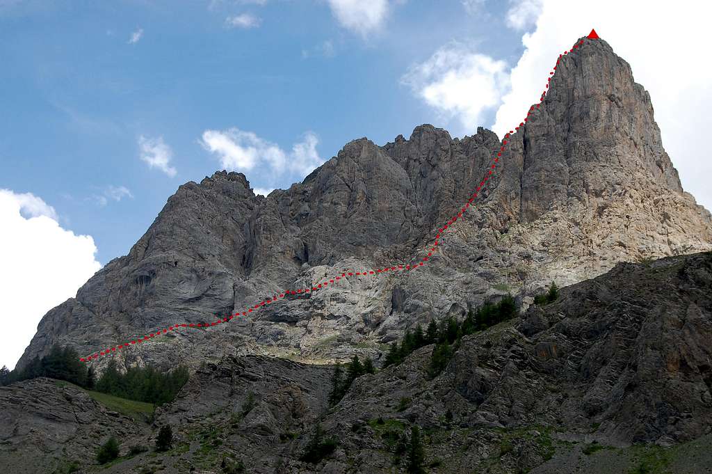
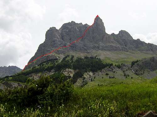
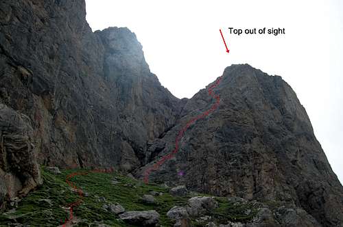
Aiguillette du Lauzet and Via Ferrata route to the summit
About 15km from Briançon stands the extraordinary pinnacle of the Aiguillette du Lauzet 2611m (8565ft). Some TD graded, serious and exposed rock routes ascend the west face (see preceding link to rampini’s excellent page) but this page is about an attractive Via Ferrata which follows a long series of ledges in a rising traverse, before rising sharply up a north-west facing facet of the west face and finishing at the summit.
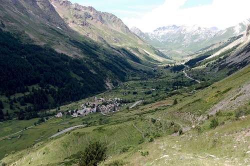
Standing in the little village of Le Lauzet the mountain appears to consist of an impregnable wall of Dolomite-like limestone, with the final pinnacle of the Aiguillette featuring as a formidable tower, piercing the sky at the far right hand end of the wall. It seems obvious to accept that this craggy tower must be the highest point – it deserves to be!
However, the whole mountain is far more complex than it appears on casual inspection. The long system of ramps and ledges that rise from left to right across the lower third of the main wall are scarcely visible from below. The castellated top of the wall also hides another feature, which is another summit which, at 2717m, is actually higher than the Aiguillette – but almost out of sight from the valley bottom (and where it is visible, it appears lower).
With 440m height gain and about 1km length the Via Ferrata is quite long but, contrary to appearances, only of modest difficulty. The overall grade is PD (Peu Difficile – or ‘a little difficult’). Nonetheless, it features a few exposed passages along the initial rambling rising traverse – and then, as would be expected, on the final ascent of the summit bastion. The small flat rocky summit boasts superb views of the valley below and across the valley to the high peaks of Massif des Ecrins.
In terms of strenuousness; the whole route, including approach and descent, constitutes a moderately strenuous day in the mountains. Reasonable physical fitness is a requirement, but with passages at or slightly past the vertical few and short lived; no great upper body strength is needed – as is the case on some of the more ferocious via ferrata’s to be found in France.
GETTING THERE
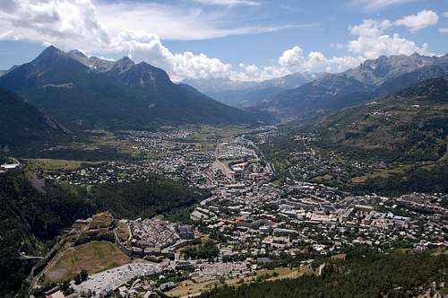
Briançon, at 1326m highest city in the EU and ‘Via Ferrata capital of France'.
The main centre is the town of Briançon which has been quoted as ‘via Ferrata capital of France’ – and is also gateway to the formidable Massif des Ecrins, which rises to over 4000m just to the southwest. Additionally it can boast some 300 days of sunshine per year – and (for those who like a little history) it was declared a UNESCO World Heritage site in 2008. Finally, at 1326m, it is the highest ‘City’ in the European Union (population 11,000+ and City defined as population >2000).
To reach the foot of the Aiguillette de Lauzet, follow the D1091 heading northwest out of Briançon and towards the Col du Lautaret. Pass through Monetier-les-Bains after about 10km and then after a further 5km pass the little slip road on the left down to the village of Le Lauzet. It is possible to park at the village or, staying with main road, at Le Pont D’Alp a few hundred metres further on.
Map
Carte IGN TOP 25: sheet 3436ET – Meije/Pelvoux/Parc des EcrinsConnections to Briançon
By road:Most straight forward approach is from the south, along N94 (from Gap, Sisteron, Marseille).
All other routes and directions involve crossing a mountain pass:
- From the west, from Grenoble slow road through spectacular gorge and over Col du Lautaret
- From the north, from Savoie most direct route over Col du Galibier and Col du Lautaret
- From the east, from Italy two attractive but relatively slow roads over Col de l’Echella or Col de Montgenevre.
By Bus:
2 buses per day from Grenoble
Bus route from Marseille to Briançon via Gap
By Rail:
There are rail connections with Paris (north), Grenoble (west) and Marseille (south).
Connections to the east are via Oulx, just across the border in Italy (and thence with Milan/Turin).
By Air:
Nearest airports to Briançon are:
Turin (Italy) – 120km
Grenoble – 160km
Lyon – 205km
Marseille – 250km.
Col de Montgenevre: 1854m pass on main route into Briançon from east, and Italy. Mont Chaberton 3131m on skyline.
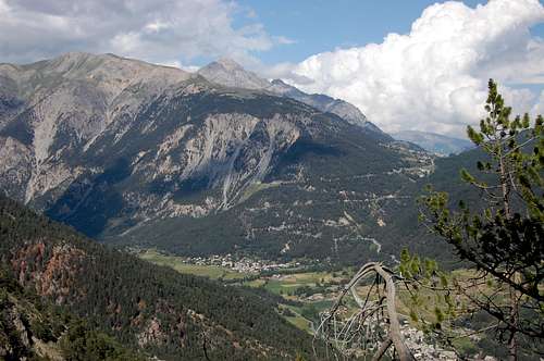
Col du Lautaret: 2058m pass on only route into Briançon from west, and Grenoble (view from Aig.du Lauzet)
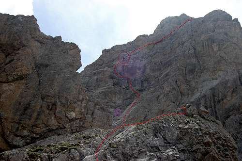
Route Description - APPROACH
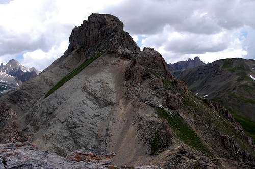
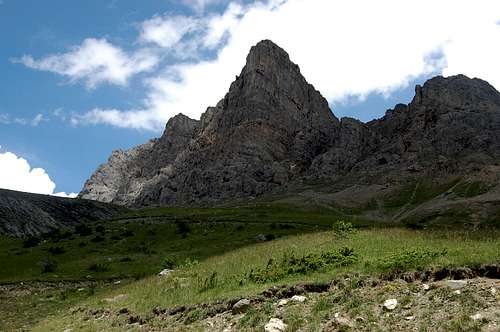
Aiguillette du Lauzet and Via Ferrata – the 2717m higher peak is visible but appears lower than the 2611m Aiguillette.
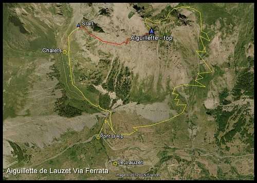
Google Earth view of Aiguillette du Lauzet with route, including Via, highlighted.
After a bend and a steeper rise, keep heading up the side valley keeping the bulk of Aiguillette to the R.
About an hour out from Le Pont D’Alp, reach the chalets.
One route description I read says “bear right just after the village and pick up the via signs”– DON’T – this will lead to a plausible and well defined trail, which slowly winds round the base of the mountain - and doesn’t go anywhere near the via Ferrata! (It does eventually link to the descent route). I made this mistake in June 2012 and it cost me half an hour before I was certain I had gone wrong. The only other person I met on the Via, later on, told me he had made the same mistake!
Instead ignore this first R turn and continue to follow the main path up the valley towards the lake (Le Grand Lac du Monetier - where most will be headed on a fine day). After a few hundred meters there is a sign, which was broken when I was there, and signs of a trail heading off the R. Follow this and in less than 100m is the rather scrappy poorly defined start to the route, at the lowest extremity of the rocks which lead to a sort of ‘ramp’ at the start of the rising traverse. This ‘ramp’ can be identified on the map as being above a few hundred meters of isolated rock band facing north-west, at the northern end of the west facing mountain wall. The initial sections of the via ascends this – in other words is above the rock band.
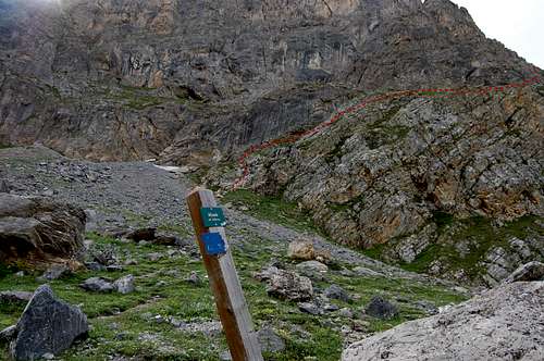
The broken sign indicating the start of the Aiguillette du Lauzet Via Ferrata
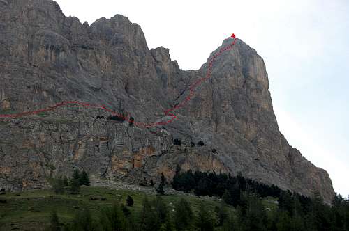
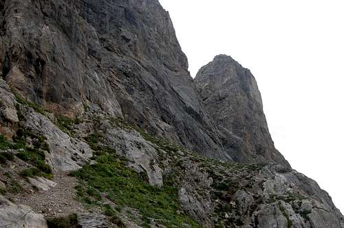
Aiguillette du Lauzet and Via viewed from few hundred meters short of the Chalets.
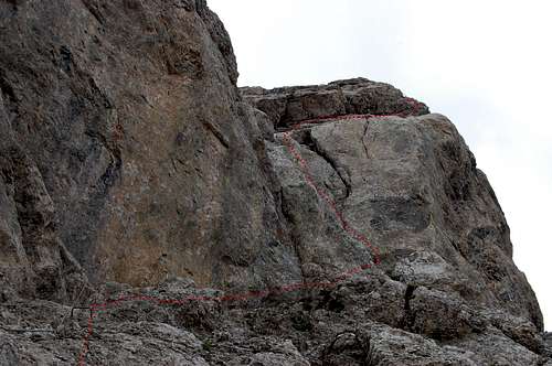
Route Description - VIA FERRATA
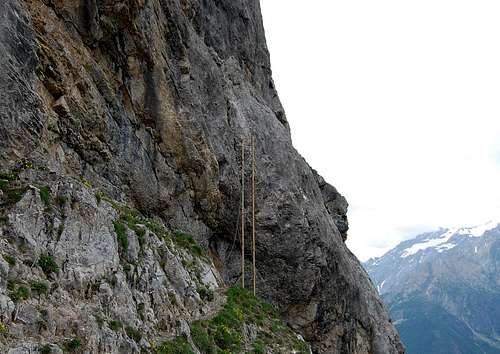
The via ferrata proper starts with the only ladder on the route
1st few hundred meters of the via marked by cables which initially are superfluous.
The start of the route is marked by a small metal plaque, which is easy to miss until you are up close. However, once you find it, all route finding difficulties are over. Even for the easy scramble at the start of the route, the way is marked by cables, which are pretty well continuous from then on, all the way to the top.
By the plaque is a good place to don helmet and via ferrata kit, but it is hardly necessary to clip on for the next few hundred metres since the route is mainly path with just the odd bit of easy scrambling. Nevertheless the terrain gradually steepens, the path gets narrower – and eases ever closer to what is becoming a significant drop, off to the right – as you turn round into the rising traverse proper, across what is the ‘front’ of the mountain as viewed from Le Pont D’Alp and Le Lauzet.
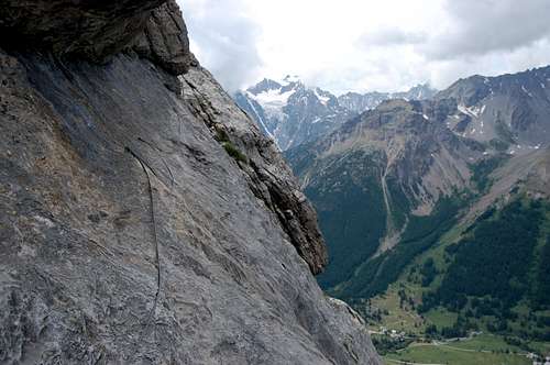
The route proper starts with a ladder (the only ladder) which links to a series of airy traverses across the buttresses of the lower 1/3 of the main wall, leading across and upwards towards the Aiguillette (which has come into view now). However, at one point the route actually descends to get round a rib and there is a particularly exposed little crossing on slabs on the other side, with mainly ‘normal’ rock footholds (as opposed to metal brackets) – but as with the entire route, always well protected.
Fairly soon after this traverse there comes a short cave section, which is a bit of the squeeze with middle aged spread and a small back pack.
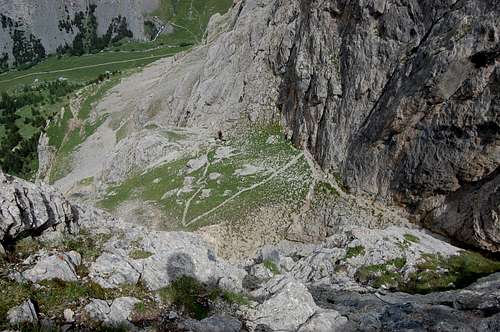
There follows some more scrambling and another airy traverse at the top of a buttress. Then, close to the start of the climbing on the actual Aiguillette itself, there as a slight reprieve in the form of a straight forward path up a cone of grassy slope.
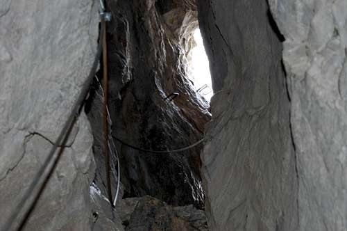
Cave section - a bit of the squeeze with middle aged spread and a small back pack.
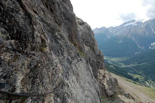
One of the more exposed traverses on the lower part of the Via
The grassy reprieve before the final tower of the Aiguillette.
Another airy traverse at the top of a buttress
At the apex of the grassy slope, the summit of the Aiguillette is no longer visible, but the next part of the route looks steep and intimidating, climbing straight up a formidable looking rock wall. Indeed it is quite exposed and metal bracket ‘foot-holds’ relatively sparse, such that (again) actual normal rock footholds have to be used in many places. But overall it is more straight forward than it looks and with no shortage of both hand and foot placements whether natural or man-made. For the most, the rock is not vertical – and the few places which are, tend to be better provided with metal brackets to step or pull on.
At the top of the buttress the summit comes back into view. Here there is another reprieve, with a short easy angled shaley scramble before the next and final rock wall. This section is a little longer than the one which preceded it and slightly more exposed with the final traverse across a slab towards the final vertical pull up to the top – which comes as a surprise.
As this final buttress is ascended (and for the first time), the nearby higher summit comes into view, on the other side of a small col between it and the Aiguillette. Without having had very close scrutiny of the map it is easy to miss this top and to have assumed the Aiguillette must be the highest point. Thus, when the unexpected top comes into view, it may come with the assumption that there must still be a long way to go.
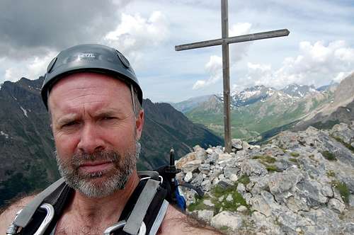
The summit is a flat area graced with a large cross – and, looking away from the unwelcome higher summit, boasts superb views, especially of the Massif D’Ecrins. The other thing I noticed about the summit is that it appears to be the territory of a large mountain goat – who featured on rampini’s page about this mountain.
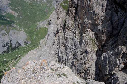
Top of the lower buttress looking down
On the lower buttress of summit tower looking down on the grassy section below
The last, steepest and most exposed final part of the Via, leading onto the top.
Top of the lower buttress looking up at final route to the top.
SUMMIT VIEWS
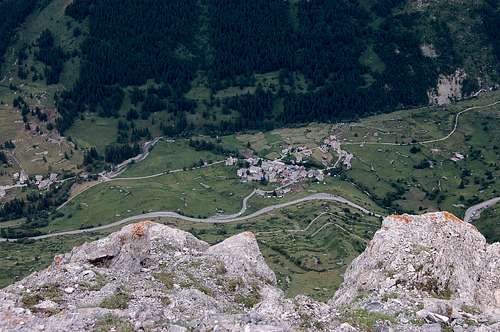
Summit view of the village of Le Lauzet 1000m below
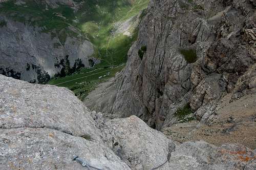
Looking down the very airy finish of the Via from the summit
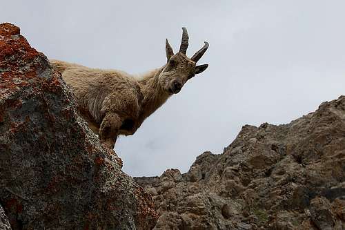
Summit fauna 2 – the other bearded old goat – and permanent resident.
Summit fauna 1 – bearded old goat beside summit cross
Route Description - DESCENT
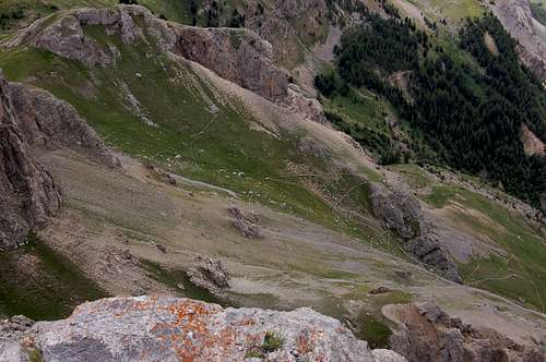
Looking down on the easy switch-backs leading back into the main valley
Initial scramble down towards the col and the unwelcome higher peak.
This mountain is full of surprises and it may come as a surprise to find that there is a walk off the top of the Aiguillette du Lauzet. At first sighting from the valley it could be reasonable to have assumed that any descent necessarily would have to involve either abseiling or a parachute.
However, a straight forward but, somewhat loose, shaley path meanders north down rocky mountainside towards the col between the Aiguillette and its slightly higher neighbour. From there – and still on loose terrain – the route follows a long descending curve, round the back of Le Pervou 2550m and thence to a more clearly defined path.
The path now descends in a series of switch-backs to the south of the Aiguillette and Le Pervou, before re-joining the side of the main valley, heading north west and continuing to descend towards the start – at Le Pont de L’Alp or Le Lauzet.
Back in the main valley; the village of Le Lauzet comes into view
On re-entry of the main valley, view of Aiguillette from the south
Timings
Approach: 1 hourVia Ferrata: 3-4 hours
Descent: 1-2 hours
TOTAL: 5-7 hours
ESSENTIAL GEAR
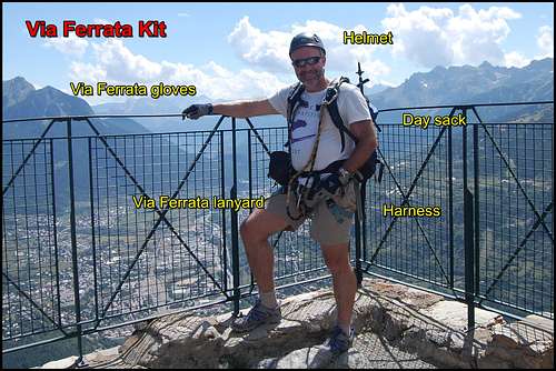
Equipped for a high mountain via ferratta.
1)Harness
2)Via Ferrata lanyard and helmet.
3)Via Ferrata gloves
4)Day sack containing essentials for a day in the mountains: warm clothes & waterproofs, water & snacks, first aid kit & mobile phone
5)Map/compass/GPS
LINKS/GUIDES
GUIDES
Cicerone guide: Via Ferratas of the French Alps by Richard Millar 2014
Via Ferrata – a complete guide to France by Chavy/Poulet 2004
Toute les Via Ferrata de France by Jocelyn Chavy 2011
ACCOMODATION
A comfortable stay with nice people and a great view: Chalet Chez Bear
WEATHER
OTHER ACTIVITIES
Walks in the area: Brianconnais walks
Mont Chaberton : Fortress SummitPost page
Riding: Grand Eagle Ranch
Mont Chaberton from Chalet Chez Bear – another worthy day out in the mountains around Briançon