
-
 12742 Hits
-
 85.87% Score
-
 21 Votes
|
|
Mountain/Rock |
|---|---|
|
|
46.38827°N / 13.37603°E |
|
|
Hiking, Trad Climbing, Scrambling, Skiing |
|
|
Spring, Summer, Fall, Winter |
|
|
7625 ft / 2324 m |
|
|
Overview
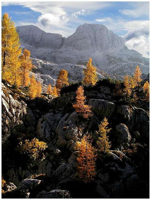 On Kanin high plateau
Its Name
In Slovenian language Žrd (pronounced something like: Zhurd) means a long wooden pole, which is put on top of a cart, loaded with hay and is tightened with ropes on both sides, so that hay stays firmly loaded. And figuratively the phrase 'tall like a žrd' means a very tall and lean person. And indeed, our mountain resembles such a long 'žrd'. It's a three-peak mountain stretching above the high karst Kanin plateau.
Zrd / Monte Sart Gets Presented
Kanin mountain world is special by its abundant karst phaenomena. On both sides of the main ridge there are broad high plateaus, which are a true playground and learning room for karst experts and speleologists. But this is also a very interesting world for mountaineers. Žrd / Monte Sart ridge stretches from the main Kanin ridge towards the North-West. With the main summit of Kanin / Monte Canin it is connected on Peravo saddle, 2040 m. Immediately above the saddle there's the fore-summit, named Vrh Grubja / Picco di Grubia, 2240 m, then the three summits of Žrd come, and after the last, and the highest one, the ridge falls steeply down and continues as a low, woods-covered ridge between the valleys of Reklanica/Raccolana and Rezija/Resia. The southern and south-western slopes of Žrd are very high, rising above Rezija/Resia valley more than 1700 meters. And the same holds for its northern slopes, which are again rising above the deeply cut Reklanica/Raccolana valley more than the same 1700 meters. The eastern and the western summit of Žrd / Monte Sart are almost of the same altitude. Officially the western summit is only 3 meters higher. That's the reason why many visitors stop on the eastern summit and don't scramble another 20 minutes to the western one and the same amount of time back. Except locals (read: hunters) almost all visitors come on the summit of Žrd from the side of Nevejsko sedlo / Sella Nevea (mountain road pass), 1190 m. Two marked paths are available for a walk-up, the shortest option is to take a cable-car up to Rif. Gilberti, so gaining altitude, and then cross the plateau to Peravo saddle and go further on top. Žrd / Monte Sart is included also in 'Ta visoka Rosijanska pot' / 'Alta Via Resiana', a marked and on Kanin area very demanding high tour, which encircles the whole valley of Rezija/Resia.
Geological Features
It is interesting that the summit of Žrd / Monte Sart (and also the neighbouring Cuel Sclaf) is made of younger Jurassic limestones, superimposed on Dachstein limestone. Even some Cretacious rocks can be found in the neighbourhood. Unusually red Cretacious rocks (called Scaglia Rossa) can be well seen on the eastern saddle, by the ascent route. Otherwise, the rest of Kanin massif has at its base Triassic Dolomia principale and on top a few millions of years younger Triassic Dachstein limestone. The result are vast karstic plateaus of Kanin massif. One such plateau is Foran del Mus, east of Žrd / Monte Sart, where you can admire splendid karst phaenomena. All water disappears underground, appearing again only in distant sources, mostly around Bovec (on the Slovenian side) and partly also above the Raccolana valley. One such source is Fontanon di Goriuda. The creek forms soon below its source a wonderful waterfall.
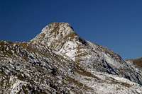
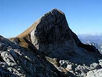 East summit East summit |
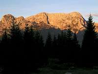 From the North From the North |
 From the East From the East |
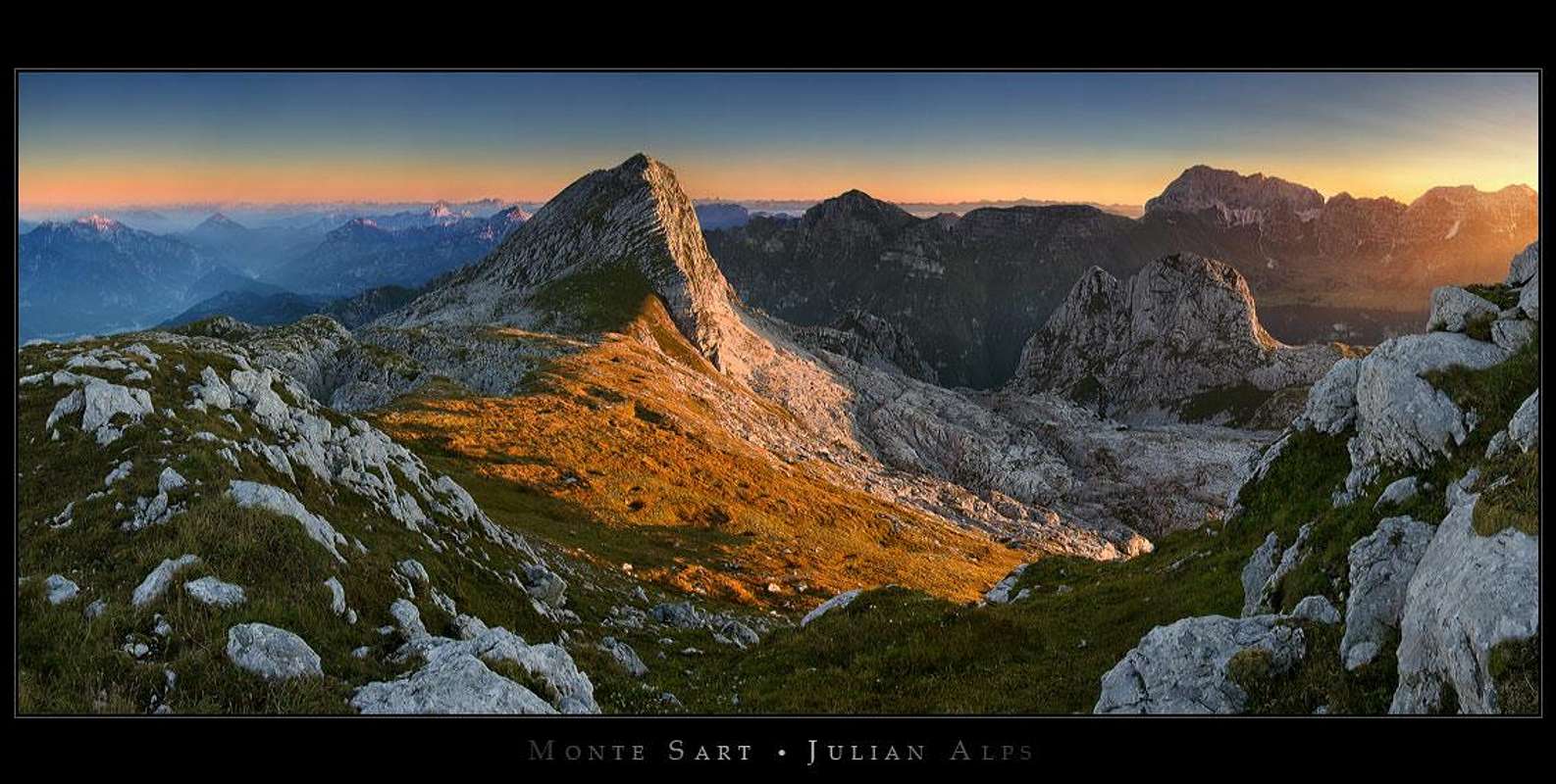
Summit View
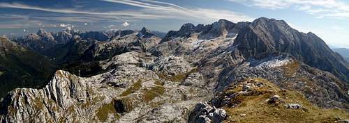 Gangolf Haub - Žrd / Monte Sart view
The panorama from Žrd / Monte Sart is very broad and interesting. You are remote enough from Kanin main chain, so its high walls can be clearly inspected. Of course, a big part of Julian Alps is hidden behind these walls. But the main summits of Eastern Julian Alps from Triglav to Mangart are very well seen - and from a different perspective. Across Reklanica/Raccolana valley the whole Viš & Montaž group is stretching. Its high summits are in front of you like on a parade. Towards the south the hilly Julian Pre-Alps are lowering down towards the Po river plane and the Adriatic Sea. And towards the West the view is completely opened across the whole group of Carnic Alps to the main peaks of Dolomites, rising sharply on the horizon.
 Eastern Julian Alps Eastern Julian Alps |
 Towards Strma Peč / M. Cimone Towards Strma Peč / M. Cimone |
 Towards the West Towards the West |
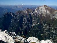
Vrh Grubja / Picco di Grubia and Cuel Sclaf
 Vrh Grubja / Pico di Grubia
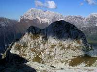 Cuel Sclaf from the route on Žrd / Monte Sart
These are the two minor neighbouring summits of Žrd / Monte Sart, which are less often ascended. Vrh Grubja / Picco di Grubia, 2240 m, is a sharp summit, rising from the ridge, which connects Žrd / Monte Sart with Kanin / Monte Canin. The marked path from Marussich bivouac on peravo saddle to Žrd / Monte Sart crosses its northern slopes, so, on its summits mainly inhabitants of the bivouac ascend. Otherwise its both ridges are quite sharp, but not hard. Some care is needed anyway. From the bivouac less than 30 minutes. Cuel Sclaf, 2157 m, is a nice side-summit, rising from Kanin high plateau NE of Žrd / Monte Sart ridge. The marked path down to Raccolana bypasses it. The summit can be reached over its east slopes. The ascent requires easy climbing (UIAA I).
Getting There
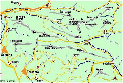 The broader Kanin / Monte Canin group
As said trailheads for ascents from Reklanica/Raccolana and Rezija/Resia are starting deep down in the two valleys. Both valleys can be reached by roads, which deter from the main road Udine - Tarvisio in Resiutta and Chiusaforte, respectively. In Rezija/Resia the starting point is Coritis, 641 m (or even below in the valley), and in Reklanica/Raccolana Tamaroz, 616m, or the main road, opposite of Stretti, 740 m. Nevejsko sedlo / Sella Nevea, 1190 m, can be reached by an asphalt road either from the West, through Reklanica/Raccolana valley, or from the Nort-East through Val Rio del Lago (from Tarvisio). The cable-car to Rif. Gilberti is operating in summer (till October) and in winter during the skiing season. Rezija/Resia is a special ethnic corner of Italy. People, living in this remote valley, definitely do speak some sort of Slavic-originated language. Slovenian people often treat them as a part of our minority (living along the whole Slovenian-Italian border), but it is interesting that many of themselves do not consider themselves nor Slovenians, nor Italians, nor Friulans. There's also a theory that their origin is a Russian one (Russia - Rossia - Rezija/Resia). They have also very special festivals, music, costumes etc.
Routes Overview
Normal ascents
1. From Rif. Gilberti, 1850 m.
From the hut you take the marked path on the saddle below Bela pec and from there cross the plateau on Peravo saddle (No. 632). From Bivouac Marussich take the marked path below Vrh Grubja / Picco di Grubia and by the summit ridge of Žrd / Monte Sart on top. 3 h 30 min (5 h from Sella Nevea), easy till bivouac, from there on top a medium hard hike-up.
2. From below Sella Nevea, 1120 m.
West below the saddle take the newly marked path on Casera Goriuda (alpine meadow), from there up towards SW on Kanin high plateau and over it to Peravo saddle (No. 645). From there on top as described in #1. Till Goriuda meadow a hard, exposed path, on many places protected with steel ropes, but with also some unprotected passages. Further on easier. 5 h. You can reach Casera Goriuda (di Sopra) also directly from Raccolana valley (No. 645). In this case you start on the altitude of some 740 m and need 30 minutes more.
3. From Tamaroz in Raccolana, 616 m.
A marked path No. 646 ascends all the way up towards the South, finally reaching the valley between Žrd / Monte Sart and Cuel Sclaf, 2157 m, and soon afterwards the Peravo saddle. Then to the top. Some 5 h 30 min. The route No. 646 is more or less a pathless terrain, but marked - hard to go, slippery, a lot of care needed.
4. From Resia, some 600 m.
The marked path No. 634 winds up over the whole southern slope of Žrd / Monte Sart towards the East, and when it passes Vrg Grubja / Picco di Grubia, it ascends the Peravo saddle. Some 5 h 30 min.
5. By the west ridge.
There are reports of this great hike-up, partially easy climb. Due to a big altitude difference (some 1800 m) it is advisable to sleep in Ricovero I. Crasso, on Buia/Buja saddle, 1655 m. From there, all the time by the ridge (so, over Picco di Mezzodi, 1782 m), on top you have some 5 hours. Steep, enjoyable, on a few places easy climbing (perhaps belaying needed). Harder Climbs No good data so far. I know only one description over the North Face (UIAA III+).
Red Tape
No red tape.
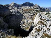
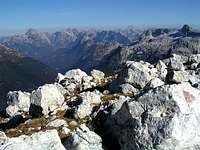
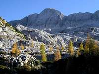 Kanin plateau Kanin plateau |
 A local climber A local climber |
 Limestone grooves Limestone grooves |
Huts And Bivouacs
 ond - Above Peravo saddle
The tour can be done in one day, but the beautifully placed bivouac on Peravo saddle is also highly welcome. On various points of the high Kanin plateau there are also bivouacs for speleologist, but I have no information about their regime of use. Rif. Gilberti, 1850 m. Standing on the high Kanin plateau below Prestreljenik / Monte Forato. It can be reached from Sella Nevea by a cable-car or by a marked path (1 h 30 min). The hut has 42 beds and is opened in summer and skiing season (no time-table on the web?), tel.: 043354015. Bivouac Marussich, 1940 m. It stands on Peravo saddle, between Kanin / Monte Canin and Žrd / Monte Sart. It is in a very good condition (2006) and has 9 places. Bivouac I. Crasso, 1654 m. It stands on Sella Buia/Buja and can be reached from the N, S or W. It is luxorious, all the time opened (2008).
When To Climb?
In good conditions Žrd / Monte Sart can be reached in any season. Even if the summit ridge is narrow and steep also towards the South, the Eastern summit can be in winter and spring also reached with skis. Crossing the high Kanin plateau with skis is anyway a very pleasant tour. If snow is hard or icy, also for the eastern summit you will need a complete winter equipment. Continuing in winter conditions on the western summit is not any harder, but for that part skis are of no use. The direct ascent from Sella Nevea (tour #2 above) can by no means be done if slopes are covered with snow, let alone ice. These north-oriented slopes are in shadow, very steep and enough dangerous even in dry seasons.
Outside links
A group of Slovenian mountain bikers, climbers, skiers (more here)... offers this: More Mountain Biking >>