
-
 4223 Hits
-
 77.3% Score
-
 8 Votes
|
|
Route |
|---|---|
|
|
40.18464°N / 5.3627°W |
|
|
Trad Climbing |
|
|
Fall |
|
|
Most of a day |
|
|
TD, max 6a |
|
|
12 |
|
|
Preface
It's long time since I've been coming to this incredible valley in the south side of the Sierra de Gredos, most of them to have amazing baths in its awesome green clear water potholes during the very hot Spanish summers or just to enjoy the atmosphere of solitude that you breath when backpacking along its ancestral trails built by the shepherds who used to live here during the summers with their cattle till the twentieth century, making cheese, drying meat, harvesting weeds, herding their animals among these grandiose mountains. All these things are now gone, and this hurts.Every single time I hiked trough these trails, I was attracted like hell by the incredible granite walls of the group of mountains called Peña Chilla a place where I knew the existence of some routes set up in the seventies (some of them longer than 500 mts.) and other lines firstly climbed by some buddies in both, the Central Summit and Punta Elena.
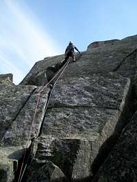
Carlos Cabeza leads the cracked third pitch on The route "Cashan" during its first acsent.
This longely expected wish came true in september 2006 in the simple way: two friends, good weather, and the right mood. The result...700 mts of rock "sailing": cracks, slabs, corners, chimneys, dizzy ridges and finaly...the summit.
Overview
Rock climbing in the mountains settled on the Garganta Tejea (south side of the Sierra de Gredos) is always an alpine adventure from the begining to the end: dirty tracks to get to the trailhead, difficult trail tracking for reaching the hut, no cell phone signal at all, no trail or cairns from the hut to the wall, a difficult stream to cross after storms, a completely clean route where you'll have to carry a lot of gear, difficult route-finding, a "bit" of lichen and moss on the rock and, of course, incredible views, amazing pitches, vultures flying around you, solitude...and a bunch of great summits to reach.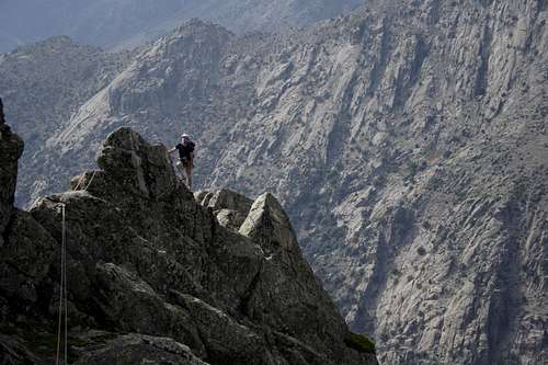
Lega climbs up the ridge on the seventh pitch during the first ascent.
The route try to cover the west ridge by its longer section, and following the most direct, though possible, line. The average difficulty is IVº/Vº (french grade) but there is a more difficult pitch, the tenth, that follows wide cracks, ending up with an off-width (6b).
Some pitches are longer than 60 mts. because we simul-climbed in the easy sections.
Save time for getting down, its not an easy bussines either.
Getting There
See the getting there section of the main page for driving directions and hut approach.Once you get to the Chozos del Tio Domingo. From there go downhill to the east, cross the stream (Garganta Tejea), and scramble to head to the bottom of the west ridge at the place where this is longer. We will begin on the right hand of a very featured moss strip.
Trailhead-Hut= 1h 50'
Hut-Ridge bottom= 45'
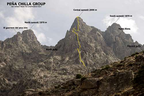
General view of the mountain with the route
Route Description
Begin the route on the right hand of a very featured moss strip and follow the topo.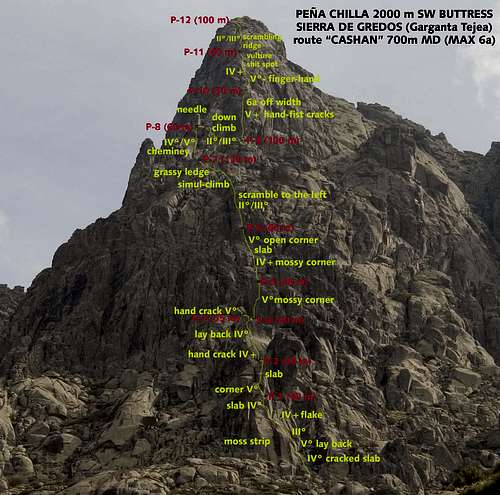
West Ridge of Peña Chilla, Cshan Route
TOPOS OF SOME PITCHES

Detailed topo of the 6th pitch.
Average Time: 8h 30' for climbing.
DESCENT: From the summit go south along easy ground sourrounding the south summit by the east till we get to a saddle that is just in the south of this summit. Go then to the west down a gully full of bushes and very steep. Don't follow it till the bottom of the valley!, better go to the right (as you go down) when you see you are lower than the base of the walls, to join with your approach path. It will take you 2 hours