
-
 10901 Hits
-
 85.36% Score
-
 20 Votes
|
|
Mountain/Rock |
|---|---|
|
|
46.39022°N / 13.86097°E |
|
|
Hiking, Mountaineering, Trad Climbing, Scrambling, Via Ferrata, Skiing |
|
|
Spring, Summer, Fall, Winter |
|
|
7900 ft / 2408 m |
|
|
What's New On This Page?
> Jan 25th, 2019: design corrections.
> Jan 30th, 2005: Initial page setup.
Overview
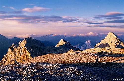
The name 'Vrbanove špice' is plural in Slovenian language. The ridge has actually two important summits: Visoka (high) Vrbanova špica, 2408 m, and Spodnja (Lower) Vrbanova špica, 2299 m.
The sharp ridge of Vrbanove špice is separating the upper part of Kot valley from the valley behind Cmir. Actually this is only the upper part of a long crest, which NE of Spodnja Vrbanova špica continues over Požgana Mlinarica, towards the main valley of Sava river. Even if the word 'špica' in Slovenian language means 'a sharp peak', 'spitze' in German, the two peaks are primarilly not mountains for hard (technical) climbing. Over the ridge goes a nice secured route, exposed and not just easy, but still, the two mountains are accessible to all with a clear head and some experience. This route is one of the most beautiful ascents on the high parts of the Triglav group where the huts, supporting the Triglav ascent stand.
As opposed to reaching the highest point over the whole ridge, ascending there from the SW, from Staničev dom (hut), 2332 m, is easy.
In the short N walls of Spodnja Vrbanova špica there are some technical climbs, which were in 1980's almost all climbed by the famous Slovenian climber Franček Knez, but today they are not much popular.
From the ridge we have a beautiful view on the north wall of Rjavina, which is just across the upper part of the Kot valley.
 |
 |
 |
 |
 |
Getting There and Routes Overview
|
So, by the Kot marked path you must reach the NE edge of Pekel basin, where you turn right. After traversing the ridge, you can return by the valley. From the middle of the ridge you can in emergency also descend towards the Pekel, but that's more demanding. |
See the broader area of Triglav subgroup to identify trail heads!
The highest point can be in 20 minutes reached from Staničev dom, 2321 m. This hut can be reached through any of the three valleys: Vrata, Kot or Krma by marked paths or through the valley Za Cmirom (Behind Cmir) - not marked. The route over the whole ridge can be done only from the Kot valley, where you park on the altitude of some 950 m. 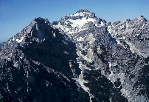
|
Red Tape
The mountain is in the Triglav National Parc, otherwise no limitations.
When To Climb
In summer and autumn - the best months are July to October.
For weather see here.
Even better site is wunderground - here's the direct link to Kredarica station, 2515 m (below Triglav summit).
Huts and Camping
Camping in Triglav National Parc is prohibited. In Vrata valley there are frequent checks for offenders. Mountain huts in the neighbourhood are:
- Triglavski dom na Kredarici, 2515 m, (04) 2023181,
- Staničev dom, 233 2m, (050) 614772,
- Aljažev dom v Vratih, 1015 m, (04) 5891030, (031) 384011, (031) 384013
- Kovinarska koča v Krmi, 870 m, (050) 631989, accessible by car.