
-
 3169 Hits
-
 76.66% Score
-
 7 Votes
|
|
Route |
|---|---|
|
|
46.44108°N / 13.48763°E |
|
|
Hiking, Scrambling |
|
|
Summer, Fall |
|
|
Most of a day |
|
|
UIAA I |
|
|
Rating the Route (By Hiking Standards)
The grading system for hiking and scrambling routes is here.
0. General: From 850 m to 2313 m, exposition E. A weak, not sufficiently marked path, not secured, a few climbing parts of UIAA I-II. Gear: Good shoes, poles. Very nice upper part. From Rif. Pellarini this is a much more beautiful ascent (for experienced) than the normal one, which can be used for a descent.
1. Effort: cca 1500 m, 4 h.
2. Power: 3 - Medium,
3. Psyche: 4 - Hard,
4. Orientation: 3 - Medium.
Getting There & Interactive Map
See the main page of Nabojs how to get into Valbruna valley. From the parking place you continue by path No. 616 and in less than 2 hours reach Rif. Pellarini, 1499 m. Easy till here.
Route Description
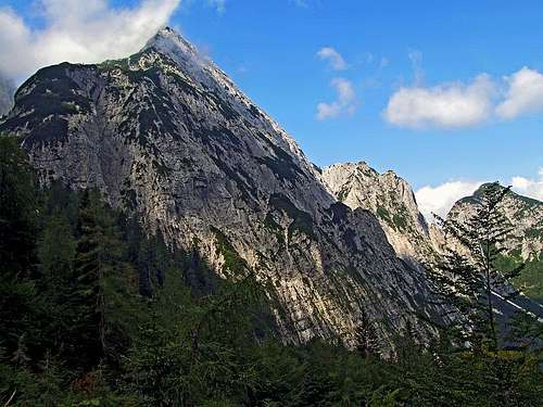
From Rif. Pellarini you continue only a few minutes towards the west by the main approach towards Sella Nabois (notch). This is still the path No. 616. On the nearby crossroad there is a clear inscription, saying that for the east ridge you need to deter right. A tiny path guides you through pine bushes. Marks on the path are washed (2007), so you need to follow the right path carefully. People seem to go there in all directions, so there are also many unmarked paths. Keep right. We came on the eastern slopes of the ridge and had to ascend over steep grass to reach the main ridge again. In any case, on 1778 m (Tabacco map) the main ridge is narrow and a good, marked path again goes by it through pine bushes.

The middle, easy climbing section
Some 50 meters higher the path goes into the left slopes. A little exposed it enters a rocky ravine and some 30 meters you need to climb up by it. In the ravine climbing is not exposed, but some details already exceed UIAA I degree. Above the ravine you reach a small, flat grassy plateau on some 1950 m. After it the path goes right up over the grassy slope towards the main ridge rocks. On them you see from the distance a red mark.

The upper part
Gaining the main ridge again the beautiful upper part of the climb begins. In easy climbing you again ascend over the rocky step. Above it the ascent becomes less and less steep and more and more panoramic. Finally you approach the rocky barrier on the ridge from before which you already see the summit cross.

Summit ridge rock barrier
At this rocky barrier you need to leave the main ridge once again. This point is not well marked, but after you start crossing the slopes towards the left (steep, rocky ledge) you will find red spots again. In front of you, not far away, you already see the switchbacks of the normal ascent, coming up from below Sella Nabojs (notch between Vis massif and Nabojs). You do some more crossing until you hit the well beaten normal path. By it you go in switchbacks up to the summit rocks and with a help of steel cables over them on top. As said, it is best to descend to Pellarini hut by the normal path, which is more comfortable.