
-
 3608 Hits
-
 84.82% Score
-
 19 Votes
|
|
Route |
|---|---|
|
|
61.42676°N / 8.14964°E |
|
|
Mountaineering |
|
|
Spring, Summer |
|
|
Most of a day |
|
|
Alpine F |
|
|
Overview
Uranostinden Normal Route (North Ridge)
When approaching the Jotunheimen Area from the South, driving along the shore of the Lake Koldedals, it appears a great panorama of distant peaks over the line of the water. One of these, situated in an isolated position to the NE of the lake, catchs the traveler's eye more than any other with its spectacular shape: it's the superb Uranostinden, in shape of a large pyramidal peak, one of the finest mountain inside the Jotunheimen National Park. With a stunning and inviting profile, Uranostinden is a wonderful and varied mountain to climb.

There are some different good routes to choose when you`re going to climb this peak, from East, South, West and North. The main summit and two minor peaks are lined up a long and thin ridge. This attractive ridge is about 6 km in length, is steep sided both to the East and to the West and runs in a North-South direction. The North side of this ridge hosts the Normal route, less difficult than it may seem, which is frequently climbed both in summer and in spring (as a ski-mountaineering ascent). However, the route crosses the Uranosbreen glacier which hosts some huge crevasses, so it requires a good glacier experience. During the winter and early spring ascents you should also pay attention to the large snow frames that border the summit ridge.
Getting There
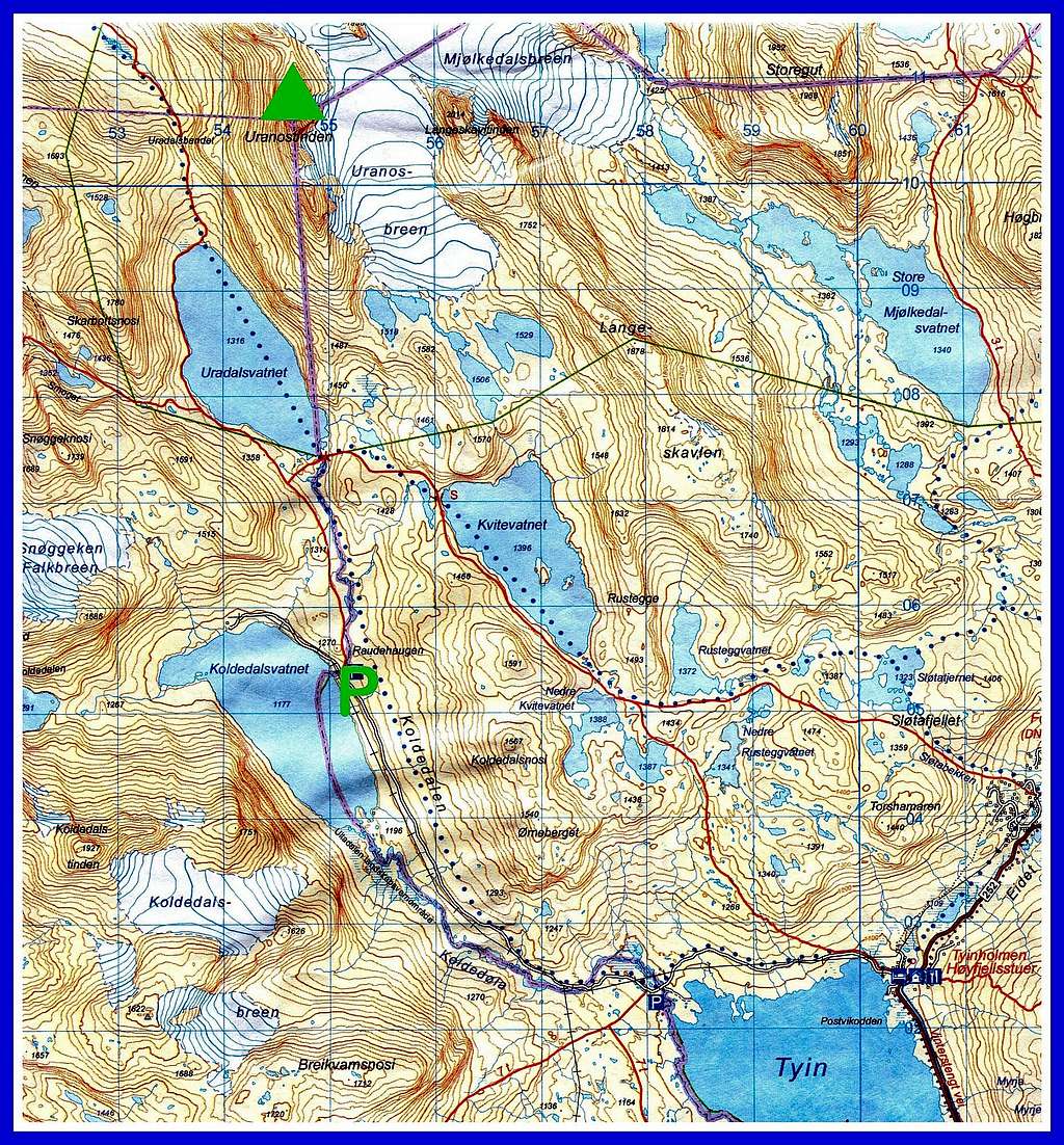
From Oslo (or Bergen) take the E16 to Tyinkrysset. At the junction in Tyinkrysset leave the E16 and take the Road 252 from Tyin to Eidsbugarden. At the following junction take the minor right road (open from mid June to mid October) and drive along the Eastern side of the large Lake Tyin, getting the Tyinholmen Hoyfjellshytter, where there's another junction. Turn to left and take another minor road running along the Lake Koldedal towards the Koldedalen valley, getting a road-bar in the locality Raudehaugen. Park the car roadside. This latter road has not a good standard, and cars with low profile tyres are not recommended.

|

|
Route Description
Uranostinden North Ridge Normal Route
Summit altitude: m. 2157
Difficulty: Alpine F+
Difference in level: 1020 m
Exposure: South, then North
Starting point: Raudehaugen m 1130 in Koldedalen
Not a difficult climb and a satisfactory advisable route up a great aesthetic peak. The itinerary follow at first a "T" marked trail, then the Uranosbreen glacier and the fine summit ridge facing North. This route should only be undertaken by alpinists provided with glacier experience and equipped with full glacier gear, particularly in late spring and early summer, when the crevasses are hidden.

|

|
Route report
The route starts on the NW side of the Koldedalen lake, just a few meters near the bridge over the stream draining the Urdadalsvatnet lake. Start 20 meters beyond the road-bar, taking to the right the well worn "T" marked trail up a steep shoulder for 10 minutes until the terrain flattens.

Continue to follow the path heading to North above the river on the west side arriving in sight of the Urdadalsvatnet lake. After about 2 km from the start the path gains a well marked junction on a hill located to the South of the Urdadalsvatnet lake. At this junction leave the main path and take on the right a well worn path heading Eastward. After the river crossing leave this path, too, and start to head Northward in direction of a small stream emerging from a marshy bowl to the south east of a steep crag which drops straight into the Eastern shore of the lake.

|

|
Go into this grassy bowl and climb up the moraine on a rough path which leads Northward until you reach the end of the moraine, where it begins the Uranosbreen. Rope up at the edge of the glacier and start to head up the slope. Obviously the glacier changes from year to year but generally there are less crevasses on the East side, nearest Langeskavltind. Climb up for a long time the glacier (about 2 km) until the glacier flattens out between the summits of Uranostind to the left and Langeskavltind to the right. Then head North-West (left) across the glacier towards the saddle between Uranostind and Slingsbytind.

|

|
There is a icy ramp which forms a glacial shelf leading up to the saddle. The route follows this shelf up to the saddle where there may be a large cornice in the spring. From the saddle a magnificent pano suddenly bursts into view over the wild regions of Hurrungane. The route up to the summit from the saddle is quite straightforward as it climbs southward up boulders following a broad ridge, alternating rock and snow in summer, while during the spring is covered by a snowfield.

|

|
Crampons and ice axe are convenient and advisable, both when the ridge is snowy and icy. In the upper part of the itinerary, as it approaches the summit, the slope becomes steeper. As the ridge reaches the summit it levels off and narrows into a horizontal and airy arête for about 200 metres. The summit is at the southern end of this airy arête. The views are unforgettable!

Descent: reversing the same route to Koldedalen
Essential Gear
Full glacier gear (rope, axe and crampons); Prusik loops and ball-knot are also recommended.
Red Tape

No particulary restrictions. The route is situated inside the superb Jotunheimen National Park, established in 1980, covering an area of 1150 square km. and including the 27 highest peaks in Norway. Jotunheimen is located between Oppland and Sogn og Fjordane counties and it's bordered by the great lake called Vågåvatnet, the valleys of Bøverdalen and Leirdalen and the road No. 55 (the mytical Sognefjellveg) to the N and NW, by the Road 51 to the East, by Bygdin, Tyin and Årdal to the South and by the mountain road between Årdal and Turtagrø to the West. More info: Visit Jotunheimen
 on the way to Uranostinden")
When to climb
- Mountaineering: the best period to climb goes from the end of June to middle September.
- Ski-mountaineering: this route is a classic in the spring on skis when much of the problems posed by crevasses are still absent.
Accomodation
In Koldedalen there are some places with vegetation where you can put your tent. Tyinholmen rents out apartments and huts. Eidsbugarden Hotel and Fondsbu are also places you can spend the night and have a meal.
Surroundings

|

|

|

|

|
|
Meteo
Guidebooks and maps


Guidebooks
- "Walks and scrambles in Norway" Hiking, Scrambling and Mountaineering in Norway guidedebook by Anthony Dyer - John Baddeley - Ian H. Robertson - Ripping Yarns 2006
- "Opptur Jotunheimen" by Finn Loftesnes - 125 selected itinerary on Jotunheimen - Selja Forlag 2009
Maps
- "Jotunheimen Vest" - Turkart 1:50.000 - 2505
External Links
- Scandinavian Mountains
- Jotunheimen
- D.N.T. Den Norske Turistforening