
|
|
Route |
|---|---|
|
|
36.52330°N / 118.238°W |
|
|
Hiking |
|
|
Spring, Summer, Fall |
|
|
A long day |
|
|
Very strenuous |
|
|
Class 4 |
|
|
I |
|
|
Overview
This is a trail description that starts at Tuttle Creek trail head and goes to the peak of Mount Langley. This trail is 4.5 miles (9 miles round trip). The trail head is at about 6,900' and Mount Langley is 14,026', for a gain of over 7,100'. It is a very strenuous day hike or could be done as an overnight. This is an alternate route to the more popular route over New Army Pass, it also gains more elevation, so is more difficult. This route starts at the Tuttle Creek trail head and follows along Tuttle Creek, but just to the Ashram, after that it vears away up an avalache chute. There was no indication of anyone traveling this route except right at the beginning, below the stone house and right at the peak. Be prepared for a day without any other company on the trail. If you like solitude this is a trail for you. No permits are required for day hikes as of July 2007.
Getting There
Tuttle Creek trail head is just a few miles out of Lone Pine. Head up Whitney Portal and turn South on Horseshoe Meadows Road. Turn West on Granite View Drive. You will now be looking up the beautiful and rugged Tuttle Creek Canyon, a rock climbers paradise. Pass south of the campground, after you pass a house right next to the South side of the road, start watching for a branch in the road on the North side that heads up toward the canyon. The road skirts along the canyon, high above the stream and is passable with two wheel drive. There is a turn around at the trail head.
Route Description
This hike was done on July 21, 2007
We had planned to overnight at the trail head to get an early start. But after sitting there a while and looking at that dusty sunny spot we noticed that the stone house or "Ashram" was visible about 3/4 of a mile up the trail. So we decided to get a head start on the morning and headed on up. The Stone House is a great place to camp and was the former headquarters of the legendary climber Warren Harding's, Low Sierra Eating Drinking and Farcing Society. It would be worth the short walk up to it for an overnight, even if you weren't going further. It has a good roof and concrete floors that were swept clean when we were there. It has a fireplace that was obviously getting used at times, though that is probably illegal and in the summer would be irresponsible. When we stayed there it was a warm night temps in the 60's. We slept listening to several waterfalls echoing in the canyons.

The stone house
We left the stone house at about 5:00 am, we back tracked about a hundred yards on the stone house trail to the point where it crosses the un-named creek, we crossed the creek and then left the trail and followed the East side of the creek up the avalanche chute toward the falls and springs noted on most topos. We are not heading up Tuttle Creek Canyon proper, we are heading into a smaller branch canyon. Head due South up this branch canyon.
After we left the very good, and very well used trail, that goes from the trail head to the stone house we never saw a human footprint or any sign of a human trail until we were very near the summit and joined the trail coming from Horseshoe Meadows. Even though you are now heading cross country with no trail and must do the route finding, this route is easy to find except at one spot, that was at the top of the tree line, climbing up through the rocks to gain the upper ridge. There is a description here of our route through that area. It was fun to be on our own and off of one of the well used trails that are so common in the Sierras. Overall there is really no issue finding your way, the forest is patchy so you can always see where you are at and the vistas are spectacular. If you can find yourself on a map you will no problems at all, and even if you got way off of our route the worst that could happen is that you might cross a little rougher terrain.
Below the springs we stayed well up on the side of the creek out of the willows, I don't know if that was any easier than following the creek bed. We were bush whacking and rock scrambling up along the side of the creek. At the springs we moved into the avalanche chute and traveling was much easier.

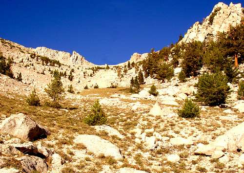
The lower avalanche chute as seen from stone house. The springs are at the shade line and the chute dog-legs to the right out of sight
We headed straight up the avalanche chute above the springs. It is easy hiking once above the springs, but steep. We traversed back and forth a bit to ease the grade. The avalanche chute has very low plants on sandy ground. It is obvious that in the winter there are frequent avalanches through this gully. There is nothing growing over about 1' tall. There are lots of pines along the sides of the chute, but none in it. This steep gully is sandy but not so bad that your shoes get filled up. There are areas with lots of the low plants to keep the ground stable. We saw a few deer and there are signs of deer all through the area, droppings, and spots where they have been bedding down . About 1/2 a mile above the springs the avalanche chute "dog-legs" and heads South-west and we made it to this bend in the canyon just at sun rise. We took a short break and enjoyed the coolness of the last of the morning shade.
We followed the middle of the chute up through the dog-leg West turn in the chute, we were now heading South-west. The upper chute terrain is very similar to the lower chute, but there are now a few pines around in the chute and they continue to get more numerous and taller as you continue up for about another 1/2 mile. You can go up just about anywhere as long as you stay in the chute, just don't get to far South because you will exit the North side of the canyon.
 Continue to head straight up the chute as it doglegs West and then at the very top of the canyon go towards the right.
We Continued to follow the chute on up a steeper section until we came into a cirque or circular head of the chute. At this point you must pick a way up the steep canyon wall to get up on the upper ridge. There was scree ahead, scree to the left, and an interesting grove of Foxtail pines on the right, we chose to go right, and headed North West into the grove of very old, and very large Foxtail pines. It is a nice grove of trees with dozens of large ones about 30' high.
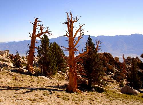 Hike through the grove of ancient Foxtail pines and make sure to pay respect to you elders
They are on the North side of the chute up against a granite wall. They look just like Bristlecones and I assume they have similar life spans. It is amazing to walk through a grove of trees that have watched more than a thousand winters come and a thousand summers go. We took a break in the shade of these ancient sentinels of this canyon and studied the ridge line looking for the best route.
Go up through the trees and find the easiest way to get up on the ridge line with views across a very steep, very deep canyon toward Lone Pine Peak, which is now North of you. The line we needed to follow became fairly obvious to us from this point. Look for a break in the cliffs that is right at the highest part of the arête that you are now on, that's the route.

The trail through the pines and up the ridge.
At this point you really can't go to far North, it just keeps getting steeper that way and the canyon drops away dramatically, one look over this cliff and you will know you are at the edge. At the tree line start scrambling through the boulders. Go the easiest way toward the ridge arête. The lower part is all class 3 and 4, easy scrambling, we didn't see any loose rock or scree. This scramble is a nice change of pace from the sandy lower sections.

Head up toward the crest of the ridge, staying far right
The upper part this very steep section is the hardest rock climbing of the entire route. I called it less than fourth class but my partner Michael called it harder at 5.0. In any case the only section that could be called rock climbing as opposed to scrambling was a section about 8' high, no exposure, that is, no way to fall any further than that. I struggle to call it technical climbing because even if you had gear you could not use it, it is too low. Maybe it is a couple of bouldering moves. Take a look at the picture and see what you think. I was standing on the ground when I took the picture and his hands are on the top of the hardest section. If you do not climb, I would not worry about this section, we just picked a line and took it. With some investigating I think you could find an easier way.

The hardest rock move of the route, I am sure if you looked around you could find an easier way.
It seems to me if you can make the rest of the route you can make it over that section. There may be alternate easier routes but this one was easy enough for us that we did not consider looking for anything easier.
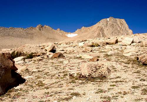
Once up over this short steep section, the summit will come into view, you can set you sights on it the rest of the way. This is about the half way mark by distance, and up on top, the ridge gets much easier. Now at 12,000' I could start to feel the air thinning, but this was still the easiest section of the route. Just follow the ridge and enjoy an easy mile long walk though granite boulders carved into interesting shapes. There are a lot of animal signs and animal trails of what I assume to be Big Horn Sheep, because I could tell that it was not deer.
 After climbing the arête, you are rewarded with this easy mile long walk
When the ridge turns into a boulder field skirt them on the south side, just stay as high as you can without working too hard. Even though I brought about a gallon of water I was already more than half way through it at this point and no where near half way through the route, my partner said he could use more water too. We decided that since we needed water and since the traverse to the snow looked like a more moderate climb we headed that way. We filled up on water from the little rivulets at the bottom of a snow bank.

We went up past the snow to get water and came down the steeper way, all easy third class through this section.
Once we had a bit of a rest making water we were feeling better and started off again.
There was another section of scrambling above the snow. We went around on the left (South) side of the snow field because it looked easier. I was having to breathe hard to catch my breath and I noticed that my finger nails were starting to turn blue, once above that scramble, we were up on the flatter area at the base of the peak, the peak boulder scramble was our last obstacle. We were both feeling the hike and the elevation gain, we were at about 13,000'. I consciously starting breathing deeper and faster.
We finally started seeing human footprints. It was a bit reassuring seeing a path leading up into the boulder field. We felt like we were going up a known path. The route up that we took is shown on my topo, It looks like it must be the route that comes from the old army pass. The bouldering here was not really much easier than what we had come up earlier that day. Another 1/2 hour of scrambling brought us up to the top.
We made the top at about 12:30. It took us 7 1/2 hours to get up. I feel like we travel fairly fast so allow plenty of time to get up.
When we started down I was surprised at how fast we could go. The scrambles weren't much faster but we avoided many of them. On the way up we stayed on the firmer ground. On the way down we went for the softer sandy scree. We started getting two steps worth of travel for every step we took. There were areas that we could literally ski down. We made time going down and it was easy. It was easy on my knees too, for me that's what hurts is the downhill. But not on this one, the soft steps in sand were great.
We made it down from the peak to the trail head in 3 1/2 hours. If I were to do this trail again I would follow the same route. I have seen other route descriptions that take other routes. We looked for other routes carefully as we hiked, and from above, other routes would definitely be much rougher. If you had to avoid the snow in the chute it might make sense to go some other way, but if snow is not an issue I wouldn't.
Myt1 - Aug 11, 2020 9:59 am - Hasn't voted
July, 2020, UpdateI recently returned from completing the Tuttle Creek to Mount Langley mountaineering route. I would have to say the route description for this climb on this website is spot-on. If you familiarize yourself with the report and the photos it is pretty hard to get lost going up. One update: the dirt road currently does not go as far as it did when the original report was written. It ends about a half mile sooner and a couple hundred feet lower than it did in 2007. Also, most of the reports spend most of their time describing the accent, rightly so, but I managed to get lost during the decent, and I even had to bivy while completely off route in the wrong drainage. Mainly this was due to me being extremely tired, and being an idiot, but there is some route finding that needs to be done on the way down. For me the problem was finding the top of the Class 3 and Class 4 section that is pretty easy to find when going up. When descending you approach this section while on a very open gradual decline with many options of decent. The problem is you need to find the exact top of the Class 3 Class 4 section and at least for me this was hard to do. I wish there would've been some cairns. On the way up, once you get to the top of the crux section be sure to take good mental notes what this looks like so you find it on the way back. As mentioned, I was extremely tired, and even though I had a map, I thought I had somehow walked too far, when in fact I hadn't walked far enough. I thought I had found some sort of alternate down climb, when in fact I descended into completely the wrong drainage and I ended up having to bivy in a very tight and over-grown canyon. It was miserable. Just be sure you can find the top of the class 3 and class 4 crux section from the top and you will be fine.