
|
|
Route |
|---|---|
|
|
37.90109°N / 107.51899°W |
|
|
Mountaineering, Skiing |
|
|
Spring, Winter |
|
|
Less than two hours |
|
|
Steep Snow |
|
|
Approach
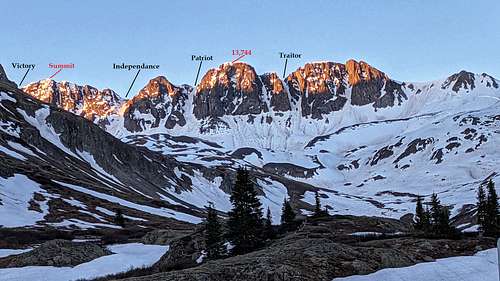
Of the four north-facing couloirs on American Peak, Traitor is the steepest. It is also the furthest from the summit and one of the shorter lines. As one is looking at the mountain, Traitor is the second snow line west of Point 13,744 (sub-summit).
Park at a small, dirt clearing off Cinnamon Pass Road (CR. #30/Alpine Loop) at American Basin. This is a separate, signed spur. So it's easy to see. This lower trailhead is located at 11,300'. There is a also a Jeep Road (#3314-12) that if melted out, 4x4 vehicles can drive an additional ~260' further into the basin to 11,550'. From here, the west face of Handies Peak is immediately to the east and UN 13,535 is to the west.
The approach to all four couloirs is apparent. Head due south crossing the basin aiming a bit left (east) towards Sloan Lake (12,900'). It is NOT necessary to actually hike to the lake for this couloir. However, by following the Handies Peak Trail for a short ways, it will undoubtedly speed your approach.
Once in the upper basin, contour southwest away from Sloan Lake towards this thin couloir at 12,810'. There isn't much of a bench at the base of Traitor. It's a moderate slope that drops into a bowl. So stomp or carve out a niche to gear up. All of these couloirs have long run-outs. So decide when to 'crampon-up,' conditions depending of course.
Route Description
Traitor Couloir is roughly 570'-600'. This largely depends on where you deem to be the start of the couloir in regards to the apron. The average pitch of Traitor taken from four separate measurements is about 41°.
Start at the bottom of the apron (36°) and contour up into the couloir aiming slightly climbers right. From the bottom, the exit is not visible. Expect to see rockfall debris on the apron as Traitor is known for it.
Towards the top of the apron/entrance of the couloir, the pitch will increase to around 40°. At this point, you will be able to see the exit and appreciate the narrowness of this inset line. Due to the possibility of rockfall, choose a line closer to the center to maximize safety.
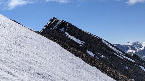
The center of this couloir is 42° and will steepen gradually as you near the exit. The top typically does not cornice and is a small col. Expect however, some cresting. The exit is ~46°. From the col, the summit is still .4 mile to the east along the ridge. There is a climbers to follow through the rock.
Essential Gear
A mountaineering axe and crampons are absolutely mandatory. Even though the pitch is low, always expect the possibility of encountering ice.
- gaiters
- shovel
- sunscreen/hat
- probe & beacon
- poles
- regular winter clothing/gear
External Links
Ski report by Scott- 13ers.com
Ski report by Natalie Moran- 13ers.com
Late spring climb of Traitor via 14ers.com
