
-
 20147 Hits
-
 76.66% Score
-
 7 Votes
|
|
Route |
|---|---|
|
|
46.37894°N / 13.84888°E |
|
|
Download GPX » View Route on Map |
|
|
Hiking, Via Ferrata |
|
|
Summer, Fall |
|
|
Most of a day |
|
|
Medium hard hike (T4) |
|
|
Introduction
| We already have a good SP page of the northern normal ascents on Triglav by Velebit. But as these routes are very popular, I think they deserve their own pages (to be searchable) and also some more information. |

Overview
Tominšek Route ( in Slovenian: "Tominškova pot") is one of the two normal, marked routes from Vrata valley to Kredarica hut (and from there further on Triglav). It is a bit more demanding than the other route (Prag Route), but the difference is not big. However Tominšek Route is some 30 minutes shorter than Prag Route and more attractive. When people ascend on Triglav from Vrata valley, and also return there, they always choose the Tominšek Route for ascent and then return via the Prag Route.
History. The path was built by the Slovenian Mountaineering Society in 1903, as a contrary to Prag Route which was built by the German Alpine club.
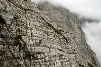
The Tominšek Route is an ideal ascent over the huge northern faces above Vrata valley, one of the most recommendable in Julian Alps. Big altitude gain is needed, but this route mainly does it in a consistent crossing. The higher you go, the more beautiful are the views, first of all on the big North Wall of Triglav, but not much less attractive are also the views on high mountains across the green valley of Vrata. Short ferrata sections are always well maintained, so the ascent is despite exposure quite safe. After you exit the walls on some 2100 m, you have only one good hour more to the Kredarica hut and another good hour to the summit of Triglav.
General Information
| Difficulty: It's a medium hard hiking tour, with many places protected by steel cables and pegs. On the Swiss Hiking Scale its difficulty would be graded T4. Many short ferrata sections would be also graded as of medium difficulty - B/C. Don't be intimidated by the Slovenian grading (zelo zahtevna pot = very demanding path). Orientation: The route is well marked (red "Knafeljc" marks). Over the wall you should have no orientation issues, however higher, on the plateau below the glacier, be careful to follow the marks. There the path is weak and there is no distinct landscape feature to help with orientation in poor visibility. Map to recommend: Julijske Alpe - Triglav. Planinska zveze Slovenije. 1:25000. See the GPX track in the header (extended to the summit of Triglav)! Exposition: Many places are very exposed, so this route is not appropriate for people suffering from vertigo.  Decades ago... Best season: Summer months, normally from July till October (or first snow). Gear: When snow rests melt, good shoes and poles are sufficient. But in early summer you will need also an ice pick. A helmet is always welcomed and for less experienced hikers and children consider taking for them ferrata sets (also for the ascent on Triglav). Tour start: End of the road in Vrata valley, 1010 m. Big, parking place there (3.5 EUR in 2015). Highest point: 2515 m (Kredarica hut) or 2864 m (Triglav summit). Altitude to overcome: cca 1550 m (1900 m). Time for ascent: 4 h 45 min (6 h on Triglav). |
Route Description
Over the Face

In the lower part
From there on, the path crosses constantly towards the right and up, across the steep face of Cmir. It mostly uses broad and comfortable ledges, but on many places there are also narrow and exposed passages. Time to time the path also climbs up the rocky steps, gaining altitude. As we approach the North Wall of Triglav, the views on it are becoming more and more beautiful. All its pillars and gullies are clearly unfolded before our eyes.
Somewhat higher the route reaches after another rocky section a very panoramic promontory, popularilly named as the Buffet. Unless you are the first one, you will certainly meet there people snacking on the nice, exposed balcony, and admiring the mountaineous world around. Then the climbing continues. The steep, most dangerous ravine (if filled with snow) is called Devil's Ravine, later many very exposed and also narrow passages come. There's more and more climbing, but we already feel the end of high walls. By going around the beautiful edge of Kozja dnina, the path finally ends it long crossing.

Views from the promontory on the mountains across the Vrata valley
Now we are just below the vertical walls of Begunjski vrh and the scree section is ahead of us. From the right the Prag Route joins us. The path keeps closely to the vertical walls and soon reaches Begunjski studenec. This is a small water source which usually has some water during the whole summer, except after long, dry periods. A true blessing in these barren rock slopes! After the water source we must continue ascending the scree slopes some 50 more meters, after which we reach another branching. Our route to Kredarica hut forks right (the left path goes to Stanič hut). Be careful not to miss it.
Over the High Plateau
Next good one hour we shall be ascending over a rugged, slanted rock desert, where we still see the remains of the Triglav Glacier. The path first crosses the lower part of the plateau, called Kotel (=cauldron). Then it continues more steeply up. It mostly avoids the remaining snow fields, winds left and right by broad gravely banks, left over by the glacier, aiming slightly towards the south west. On the right is the summit of Triglav and we must reach the saddle between it and the Kredarica ridge. From the saddle, the majority of hikers goes first left to the nerby hut, but we can also save those few minutes if we continue the same day on the summit of Triglav.