
|
|
Route |
|---|---|
|
|
46.88008°N / 8.64970°E |
|
|
Hiking |
|
|
Summer |
|
|
Expedition |
|
|
Steep trails |
|
|
Overview
Just walk. Then keep walking. Accept the stupidity of this. Sleep and do it again. You may find a kind of heaven on earth.
Three weeks. Over 20,000 meters elevation gain and loss. 360 kilometers or so, give or take. The Via Alpina through Switzerland leads you through passes and villages, under imposing peaks, beside gorgeous waterfalls and across high alps drowsing in the summer sun. There is enough "Gee, whiz!" scenery to satisfy the most voracious bucket-lister, but enough long stretches in forest or beside road to test your resolve and send you within to ask the question "why am I doing this?" Especially if it's raining. In the end, those "hard parts" that require introspection may well be the secret gift of the trail.
No matter what, the experience of crossing such rich country on your own two feet for many days will change you. In my case, I learned how little I actually need, and how much nature offers in generous proportion. I would walk every step again in a heartbeat.
What is the Via Alpina
It's a sign of a good thing that it appears with many names, and our trail here is like that. First it was the Alpine Pass Route (APR), an unofficial but widely used appellation. Later, the "Via Alpina" as a network of trails came into existence, "created by a group of public and private organisations from the 8 Alpine countries in 2000" (quoting from Wikipedia). With some variations, the Via Alpina Green Trail follows the Alpine Pass Route. Finally, an official Swiss route was established called the Swiss National Route Via Alpina One. It's easiest for me to conceive of all these namings as a rather stilted conversation between official organs, though of course, guided by hikers who love the routes just as we do.
It's easy to stay on track, and the symbol below will likely become a component of your dreams.
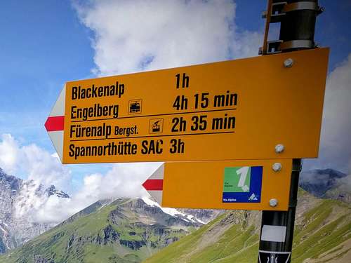
Distinctive signage
With over one thousand meters of elevation up and down per day, the route piles up a lot of elevation. Considering that summits aren't part of the route, you'll be surprised how often you are in steep terrain! In my version of the trip, I added a few summits, but even without that, you'll have strong legs by the time you are done.
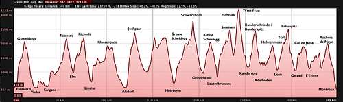
Via Alpina Elevation Gain/Loss
Getting There
Feldkirch offers train connections from anywhere in Europe. The official start of Gaflei is just odd, but you should be able to take a bus from Vaduz there if you like. Sargans is also reachable by train should you wish to start there.At the other end of the trail at Montreux, there are also numerous train, ferry and bus connections. Throughout the journey, it's easy to exit and return via numerous lifts, post-buses and occasional train stations and rent-a-bikes to zoom down to a valley (Grindelwald in particular). The only thing to keep you on the trail in bad weather is will-power!
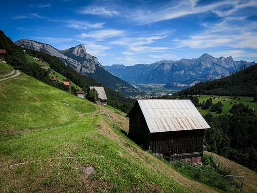
![Looking back to Sargans]()
On the way to Weisstannen and high mountains
![Unnamed Image]()
![Above Meiringen]()
Above Meiringen
![Grindelwald at Dawn]()
Grindelwald at Dawn
![Mürren and the Eiger]()
Mürren and the Eiger
![The Ripsawridge at Rest]()
Ripsawridge at Rest
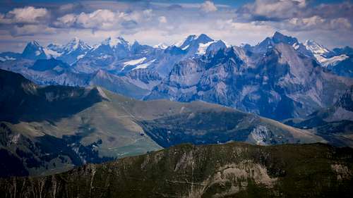
![Looking back from the Giferspitz]()
Back to the east, where the giants live...
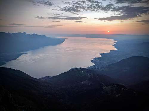
![Lac Lamon]()
The end of the journey...
Route Description
I'm first describing the route as I did it, because that's what I actually know. A few things to note:- I started at Feldkirch, not at the official start of Gaflei in Lichtenstein (a ridiculous start point) or Sargans in Switzerland. My idea was to find a natural start point that allowed me to "look into" the trail to come, from the high crags above Vaduz. It would allow me to tag Gaflei for the sake of completeness. I could also easily reach Feldkirch in a few hours by train from home.
- If time and weather permitted, I tried to include a peak. The largest undertakings being the Schwarzhorn above Grindelwald, the Wildi Frau above the Hohtürli Pass, and the Giferspitz on the way to Gstaad. In retrospect I have to say the Wildi Frau was unadvisable without a rope (UIAA grade III+ rock climbing)! Coming from the climbing world, I really value the overview attained from a summit.
- I tended to prefer sleeping high at an Alp rather than down in a town, but the place to sleep was always a relatively spontaneous decision in which weather played a large role. Stopping early in Brüsti allowed me to enjoy the Surenenpass in good weather instead of murk. Avoiding the hustle and bustle of Grindelwald and Lauterbrunnen with stays in First, Alpiglen and (Hoch) Mürren kept the solitude factor high.
- I was adamantly opposed to any kind of mechanical uplift or aid. I had the luxury of enough days to do this, and found it very rewarding to impose this rule on myself.
- Some days were long/hard, but I could enjoy being lazy too. The full day spent at Oberi Bundalp co-inciding with poor weather was a wonderful luxury and chance to recharge for the last stages.
| Stage | Start | Finish | High Point | Elevation gain |
| 1 | Feldkirch | Vaduz | Kuegrat | |
| 2 | Vaduz | Weisstannen | ||
| 3 | Weisstannen | Elm | Foo (2222 m) | |
| 4 | Elm | Linthal | Richetlipass (2260 m) | |
| 5 | Linthal | Urnerboden | n/a | |
| 6 | Urnerboden | Attinghausen | Klausenpass (1948 m) | |
| 7 | Attinghausen | Brüsti | n/a | |
| 8 | Brüsti | Jochpass | Surenenpass | |
| 9 | Jochpass | Meiringen | ||
| 10 | Meiringen | First | Grosse Scheidegg | |
| 11 | First | Alpiglen | Schwarzhorn (peak) | |
| 12 | Alpiglen | Mürren | Kleine Scheidegg | |
| 13 | Mürren | Oberi Bundalp | Sefinafurgga | |
| 14 | Oberi Bundalp | Kandersteg | Wildi Frau (peak) | |
| 15 | Kandersteg | Adelboden | Bunderspitz (peak) | |
| 16 | Adelboden | Lenk | Hahnenmoospass | |
| 17 | Lenk | Gstaad | Giferspitze (peak) | |
| 18 | Gstaad | L'Etivaz | Col du Jable | |
| 19 | L'Etivaz | Rochers de Naye | ||
| 20 | Rochers de Naye | Montreux |
Stage One: Feldkirch to Vaduz
The idea is to walk south out of town and get up onto the long North-South trending ridge with the Drei Schwestern, Garsellikopf and Gafleispitz. There is a kind of via ferrata descending the south side of the Garsellikopf, rather steep. Unfortunately I was usually in cloud for this section, so my views were limited to the crags around and occasional glimpses to the broad valley of the Rhein below. Lots of up and down on the ridge, until finally beginning the steep descent to Gaflei (kind of a parking lot/bus stop). From here, a mix of trail and rather tedious roads lead down to Vaduz. Vaduz is unfortunately quite expensive to sleep in, I think it was the most expensive night for just an okay hotel room. Better probably to get away from the bankers, though this was a very big day and my feet were toast!
Stage Two: Vaduz to Weisstannen
I was blessed with good weather for the walk across the Rhein from Lichtenstein into Switzerland. Pleasant small roads and trail lead easily to Sargans. I stuck to small roads above Sevelen, heading southwest. I dropped into Sargans, cooled my burning feet, then started up past St. Martin then made the long but enjoyable walk southwest to Weisstannen. A dinner of fresh-caught trout at the restaurant in town, then camping not far from the trail south of town.
On the way to Weisstannen and high mountains
Stage Three: Weisstannen to Elm
Continue up the valley, along the tortured Seez River, exiting the gorge at an alp (1881 m), then heading up west in cow country to the Foo pass (2222 m), the first official pass of the route! Now you are a mountaineer. Descend the other side to Raminer Matt (1896 m), then down the Raminbach on trail and road to Elm. Several points of lodging available in this town, I stayed at the Gasthof Sonne.
Stage Four: Elm to Linthal
Hike steeply up the wooded hillside west to Empächli (1475 m), then make your way on trail and road to the Obererbs Skihütte (1690 m), at which point scenery becomes more alpine, climbing up and west into the beautiful Chüeblad basin under the Gross Chärpf (2793 m), which would make a great extension to the hike if time and weather permit. Continue into the flat Wichlen Matt and an alp at 2036 meters. The Richetlipass (2260 m) is due west from here, not far. The descent to the Hintere Durnachtal and Unterstafel at 1360 meters is quite steep, and rather annoying if the grass is soaked. I had to wring out my socks several times! Continue down the long valley on trail and road to Linthal, which has lodging, food and a post office.
Stage Five: Linthal to Urnerboden
Officially, the "stage" goes from Linthal to Altdorf, which would be a very long and punishing day! I had the worst weather of the trip on this day, so I took it easy. I first climbed steeply to Braunwald on an interesting trail/road with many switchbacks. Travel south and west along the hillside to enter the deeply impressive Urner Boden, likely exiting trail for either road or more trail on the south side of the road at Hinterstafel. A collection of buildings at Urnerboden features a hotel/restaurant and a small store. I enjoyed staying here on a rainy night.
Stage Six: Urnerboden to Attinghausen
Follow trails and occasionally the road towards the Klausenpass about 500 meters higher, then trail on the south side of the road until the road begins descending to the western valley floor. A mix of roads and trails (it would be pointless to describe them in detail) continues west...in general, stay as high as you like...ideally remaining in alpine pasture all the way to Altdorf. In my case, heavy rain sent me to the road at Spiringen, a bit more than halfway between the Klausenpass and Altdorf. Altdorf is a relatively large, historic and low-elevation town (only 458 meters!), with plenty of shops. I walked on to Attinghausen, and stayed in the Hotel Restaurant Krone for the night.
Stage Seven: Attinghausen to Brüsti
This is a rather short stage, my excuse is that it was the tail end of the bad weather window, and I wanted to save the fabled Surenenpass for a clear dawn. It's a climb of only about 1000 meters up steep trail through pleasant and little-traveled alp and forest to Brüsti. If life me, you have rainy weather, you could do worse than to hole up in the Berggasthaus Z'Graggen. Here I discovered Käsebrot, a fantastic Swiss grilled cheese sandwich. Combined with great bowls of milk coffee, I fortified for the journey ahead and caught up on necessary reading and writing at this wonderful refuge.
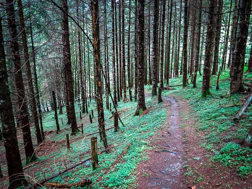
In worsening weather, a forest above Linthal offers respite from rain.
Stage Eight: Brüsti to Jochpass
With a climb of only about 700 meters to the Surenenpass (2291 m), you'll be there pretty early. I couldn't resist running up the Eggenmanndli (2448 m) for even broader views of the Blackenstock dominating the southern view. A gorgeous trip down to the flat Blackenboden (refreshments available at an alp here) followed. The route follows the valley around the Wissberg (2671 m) to reach the lovely vacation village of Engelberg (1003 m). I stopped at the supermarket here for supplies, but it was early enough that I wished to press on, invigorated by the broad blue sky after days of rain. The route climbs south and up through forest to the Gerschnialp (1256 m). An impressively steep trail climbs under a funicular to the Trüebsee (1764 m), decorated by some gorgeous but expensive hotels. I know that the Jochpass (2207 m) offered a bed for the night, so I pressed on, finding good food and accomodation. The sane thing to do would be to stop in Engelberg for the night, but I enjoyed this day so much, and although my legs were sore, my heart was soaring.
Stage Nine: Jochpass to Meiringen
A morning walk down to the Engstlensee (1850 m) under impressive subpeaks of the Titlis mountain started the day right. Now back up a bit to the Tannalp (1974 m) by the Tannensee, then a short climb to one of the great ridge walks of the hike: from the Ärxegg to the Balmeregghorn at 2255 meters. You'll take many pictures here! You'll continue traversing high above the Gental to Planplatten, where a funicular offers a pleasant ride down to Meiringen. Say no to such luxuries! For you, trail and road on gorgeous alp-land leads down to Hasliberg, a vacation village 400 meters above Meiringen. The descent leads through woods, across meadows and along babbling creeks. Meiringen (595 m) has many choices for accommodation, but Simons Herberge suited me perfectly.
Above Meiringen
Stage Ten: Meiringen to First
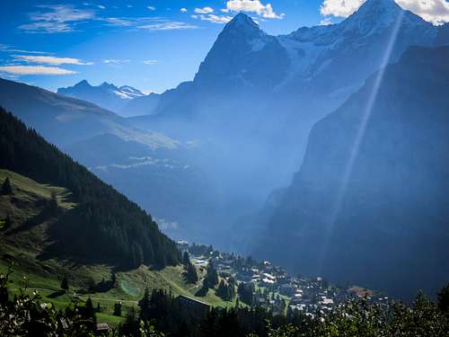
Follow signs from town to the Grosse Scheidegg, first passing the Reichenbachfall, site of the fictional death of Sherlock Holmes! Lots of wandering through woods and along a stream, then more open country to the pass at 1962 meters. From here, I left the official trail, taking a scenic balcony trail to First (2184 m) with gorgeous views of Grindelwald, and the peaks from the Wetterhorn to the Eiger. The restaurant offers a small hotel and a cozy dinner service for the few guests.
Grindelwald at Dawn
Stage Eleven: First to Alpiglen
A big day which began with a beautiful sunrise and early climb of the Schwarzhorn. I went up the via ferrata, though views from the normal way are just as impressive. On the long hike down to Grindelwald, I gave myself a treat by renting a standing bike for the last 500 meters of descent to town. Absolutely wonderful! After some shopping for supplies, I set out rather tiredly in the hot afternoon for Alpiglen, where a warm dinner and bed under the imposing walls of the Eiger cheered me back up.
Stage Twelve: Alpiglen to Mürren
Happily I reached the Kleine Scheidegg after an hour of hiking, long before the tourists arrived. From a distance I smelled Japanese "ramen" noodles, served in great abundance at the pass to cater to tourists from far away. The descent to Wengen was absolutely lovely. I really saw almost no one, and found it odd that this would be one of the most deserted sections of the hike, when the scenery was so categorically sublime. Lauterbrunnen was brutally hot, and drinks by the public pool cooled me off for the forested walk to Mürren. I made a friend on this walk from Canada, and we shared a beer and some bouldering around the village before I settled in for the evening at the Pension Suppenalp, about 20 minutes walk above the town.
Mürren and the Eiger
Stage Thirteen: Mürren to Berghaus Bundalp
I took a higher route to the Sefeinen Pass than usual because of my lodging above the town, and highly recommend this lonely and scenic variant. I passed the Schiltalp (1946 m) and the Rotstockhütte (2039 m) before reaching the pass at 2612 meters. The final 100 meters or so were probably the steepest offered on the official trail. A party of older folks from France had quite some trouble coming down it and I offered assistance in carving or pointing out good footholds in the black, crumbly schist. I sat for a long time at the pass, and made some friends. Heading down (again steeply, but not as bad), I crossed the Gornernbach then headed back up for an hour to reach the Oberi Bundalp (1840 m), my place for the night, and indeed the next night.
I'd finally earned a full rest day, which happily coincided with a day of rain in the midst of a long fair weather spell. I couldn't be more pleased!
I'd finally earned a full rest day, which happily coincided with a day of rain in the midst of a long fair weather spell. I couldn't be more pleased!
Stage Fourteen: Berghaus Bundalp to Kandersteg
A long and rewarding day, first climbing to the Hohtürli pass (2778 m), then enjoying a coffee in the Blümlisalphütte before a rather daring rock climb of the Wildi Frau (3260 m). Please folks, use a rope if you do this...it goes at a rather steep grade of UIAA III+ (about 5.4 in the Yosemite Decimal System), marked by one 10 meter section of maximum difficulty for the grade on smooth rock near the start of the climbing proper. After this a descent through some of the most gorgeous country of the trip, traversing above the beautiful Rossbode See to Oberbärgli and finally ending at the sublime Oeschinensee (1522 m). Pleasant forest road and trail lead from here to Kandersteg, place of food and rest.
Ripsawridge at Rest
Stage Fifteen: Kandersteg to Adelboden
Heading south of Kandersteg along the river, you'll have the novelty of passing the official summer camp of the Boy Scouts. I couldn't repress an amused smirk at seeing miserable boys shepherded by their parents as if to the gallows, all moving glumly to the entrance of the complex of buildings. Happily, I was free, unlike them! A very interesting trail now leads steeply up in many switchbacks to the Bunderchrinde (2385 m). The direction of travel changes in unusual ways and keeps you guessing. I couldn't resist a climb of the nearby Bunderspitz (2546 m), which offers excellent views looking back into the high Berner Oberland, and milder but still mysterious views off west to your future. A pleasant descent to Adelboden follows, marred only by the fact that you'll have to climb over 100 meters up to the town on the other side of the valley. My choice of lodging was poor, as it stranded me back down in the valley bottom, the opposite of my direction of travel. But I had a television set for the first time, and happily watched my countrymen in the USA celebrating an eclipse visible across the nation.
Stage Sixteen: Adelboden to Lenk
The mildest hiking stage of the tour, you'll only have to contend with the low Hahnenmoss Pass (1950 m) today. It's graced by restaurants and such, too, so make sure you got your fill of "high and wild" earlier! On the west side of the pass, I enjoyed watching remote control planes fly around above these pleasant and often forested mountains. Easy descent to Lenk, at which I highly recommend a stay at the Hotel Garni Alpina.
Stage Seventeen: Lenk to Gstaad
Walk west and uphill out of town into forest and an exciting trail along the Wallbach with many small waterfalls. More open country leads to the Trütlisbergpass (2038 m) and only a few minutes later the Türli Pass (1947 m). Here I left the official trail which descends the Turbach valley in favor of a westerly route to the Turnelssattel, then steeply up to the Giferspitz (2542). Views from this peak were amazing. On the whole, it's probably the most rewarding peak view of the trip because of considerable prominence relative to the surrounding country. From here, a natural descent first north then west to Gstaad (1186 m), where lodging is available. This is rather a fashionable town, so it's more expensive than usual, but you've earned it.
Back to the east, where the giants live...
Stage Eighteen: Gstaad to L'Etivaz
We finally cross the language barrier on this day at the Col de Jable (1884 m), reaching it via a climb through forest to open country, then up and down a bit to the Trittlisattel (1850 m), thence down a bit to round the Höje Stand and then to the pass, marked by a low stone wall. On the other side at the Gros Jable (1824 m) they don't speak German or English -- only French, and they don't much like inquires about food or water -- I had crossed a cultural border, and enjoyed being reminded that the world was not created solely for me! A traversing descent through pleasant forest led to lodging at L'Etivaz. You should call to secure a place here, the hotel is not very big.
Stage Nineteen: L'Etivaz to Rochers de Naye
A rather long day. First through forest on the south side of a major road to La Lecherette, then along road which rounds the east side of the Lac de l'Hongrin to the Col de Sonlomont (1503 m). Ascending slightly on a westerly walk, you'll reach a high point of Linderrey (1669 m), then descend steeply to the valley floor of La Pertuse. Climb back up into the valley Chaude, where a farmhouse at 1470 meters offers some cake and drinks. The Col du Chaude at 1669 meters follows, and you'll have a tantalizing glimpse of the Lac Leman! The final climb to the Rochers de Naye (2042 m) is absolutely gorgeous, with Montreux far below, and the world of high mountains now firmly behind you. You can stay for the night at the Rochers de Naye in a hotel/restaurant. I visited the summit at sunset for a sublime view.
The end of the journey...
Stage Twenty: Rochers de Naye to Montreux
It's all downhill from here...descend to the little pass Sautodox (1832 m), then continue west down the ridge to Sonchaux (1258 m) from which a long road winds back under the summit through forest to Caux (1050 m). Don't miss the lovely Gorge du Chauderon on the way down to Montreux. After only a few minutes walking through busy and narrow streets, you find yourself standing by the broad lake, wondering what ferry to take.
Congratulations!
Essential Gear
Standard hiking equipment is fine, though you should travel just as light as you can. This trail makes ascent and descent to a valley base almost every day, so the elevation gain is prodigious. Having done several week-long trails in Europe I was frankly unprepared, having grown used to "balcony" trails that stay high above a valley for days. This route is quite different from that!I began with spartan camping equipment (no cooking, a tarp and a summer down sleeping bag), but was able to use it so rarely that I eventually mailed it back home. My pack was exceptionally light. My luxuries were a Kindle, an MP3 player, a journal and an important paperback book. I had a camera with charger and extra battery. Gloves, a warm hat and a sun hat were important. An umbrella made the days of rain bearable! I carried hiking poles in my hands. I wore trail running shoes, and rather thicker socks than most would choose (Thorlo Mountaineering socks). I had jogging tights and a pair of pants, and tended to alternate them. I had two shirts, and an extra pair of socks.
Sunscreen, money, sunglasses and a light jacket rounded out my kit. I would carry neither more nor less in future.
External Links
Mapping
- Official Swiss Topo Map - the Online Viewer is good, there is also an Android/iPhone app.
- Topo 4U Map - I've been a fan of this rendering of Open Street Map data for a while, though the web viewer is a bit slow and awkward. If you are looking for scraggily bits of trail between roads they show up best here. The link is centered near Elm, on the eastern part of the trail.
- Open Topo Map - A faster more ergonomic site for viewing Open Street Map data with topographic information. I just don't like the rendering quite as much as Topo 4U.
The Route
- Official Via Alpina Site - with a link to the "Green Trail," the shorthand name for this crossing of Switzerland.
- Swiss Mobility Via Alpine Trail "1" Site - also very good.