
|
|
Mountain/Rock |
|---|---|
|
|
38.65624°N / 109.36739°W |
|
|
Grand |
|
|
Trad Climbing, Aid Climbing |
|
|
Spring, Summer, Fall, Winter |
|
|
6565 ft / 2001 m |
|
|
Overview
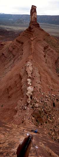


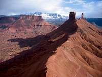
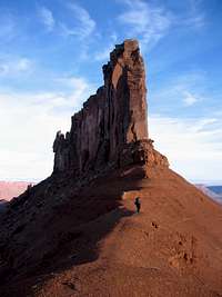
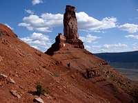
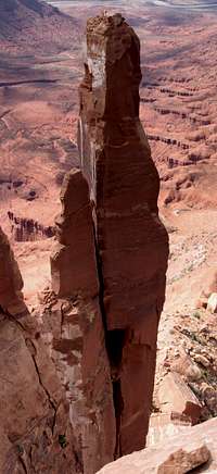
The Rectory is the prominent, narrow mesa located in Castle Valley, Utah. With its dead vertical (or overhanging in places) nearly 400-feet tall walls, it is located on the ridgeline running between Castleton Tower (to its south) and The Convent Mesa (to its north). Nearby neighbors that share the ridgeline also include The Nuns (a semi-attached, blocky tower on its north side), The Priest, and Sister Superior Group. All summit routes require serious technical rock climbing – either 5.11 (or harder) free or runout, old school “5.9” (Empirical Route, “5.9” R for example) or aid (Farewell To The Desert, 5.8 C2). Route (summit routes that is) lengths range from 2 to 4 or 5 pitches (grade II to III). There are no scramble routes to the summit. The stone here is the same high-quality Wingate sandstone you likely experienced earlier on Castleton (or Sister Superior, or Priest…) though there are small bands of stuff that feels a little like Entrada (softer and sandier). The summit of the formation offers an incredible experience in its own right – a sprawling, mostly flat desert prairie high up in the sky! At about 50 yards across and several hundred yards in length, there’s plenty of room up there to un-rope and hike around! And yes, there is crypto soil there too so stick to the slabs and watch where you step. DON’T SPOIL THE SOIL! Much of the SE Utah desert is home to Cryptobiotic Soil Crust. Watch where you step as this stuff is extremely sensitive and this “stuff” is also what’s keeping erosion at bay on hillsides. The NPS recommends using established trails, sandstone slabs, and/or sandy washes for your foot travel. For further information see the many links provided by Dr. Brian Jenkins: link 1, link 2, link 3, link 4, link 5, link 6 While on the topic, don’t soil the soil either! Don’t be a filthy animal and pack out your solid waste!

Getting There


The Rectory is located in Castle Valley immediately north of Castleton Tower. From West (Moab, UT): Just beyond the northern outskirts of Moab along US 191, make right (northeast) onto highway UT 128 (a.k.a. River Road). Follow this highway for about 15.7 miles for a marked turnoff for Castle Valley Road. Make right onto this road and follow it for about 4.4 – 4.6 miles (depending on your odometer). Make left onto an unmarked (and not overly obvious esp. in the dark) dirt road. Follow road for a few hundred yards until you run into boulders blocking further passage (there’s also a sign board). Park the car. Note that this trailhead makes for the shortest approach to Castleton, Rectory, and The Priest. Driving time is approx. 30 minutes from Moab. From East (Colorado): From I70, take exit 212 (in Utah) and turn right onto frontage road. Follow this road SW through ghost town of Cisco (c. 5.7 miles from exit) and until you reach UT 128 (River Road) at 8.3 miles. Turn left onto River Road and follow it to Castle Valley Road at 28 miles from exit. See directions above from here. Note that these directions were copied from C. M. Burns’ Selected Climbs In The Desert Southwest – Colorado and Utah. The Hike:From the trailhead, hike past the small-boulder barricade and enter a small canyon. Follow a trail which stays mostly near the bottom of the canyon. There are a few class 2 rock steps in the trail. As you top out on a minor hill (several hundred yards from the trailhead), you’ll be looking at the base of the talus cone of Castleton Tower. Take your time here and spot the climbers trail heading up and toward the talus cone (fairly well-beaten and generally marked with cairns). Cross a perimeter dirt road (which partially encircles the base of the cone) and pick up the climbers trail. The trail passes the lower rock band of the talus cone via an easy notch (class 1-2). Above, it soon reaches the base of the second rock band beneath Castleton Tower (see here). Just beneath the rock band (literally next to the base of the band), turn left toward Castleton-Rectory saddle on a faint climbers trail. The trail follows this upper rock band at about constant elevation. It then cuts left beneath the base of the NW corner of Castleton and heads for the very scenic Castleton-Rectory saddle. Hike the saddle towards the south edge of Rectory atop the crest. Approach time from trailhead is ~ 1 hour.
Red Tape
The Rectory lies on BLM land. There are currently no permits or fees required to hike in the area or park at the trailheads. Dogs are allowed in the backcountry here (pick up their turds!). Please practice zero-impact backcountry use.
Camping
Camping at large is (most likely) allowed in the area. There are no water sources in the backcountry however. Good (primitive) campsites are available off of the dirt road near the trailhead. However, best campsites can be found along the second dirt road – i.e. from Castle Valley Road, pass the trailhead turn off road at 4.6 miles and take the second dirt road (also on left) few hundred yards further. Several hundred yards from Castle Valley Road look for campsites. Note that you can also begin your approach hike here.
Mountain Conditions
Local climbing information can be obtained from the friendly folks in the local climb shop, Pagan Mountaineering located in Moab, UT. Their number is 435-259-1117. Also check: Moab Climate Summary Page. Moab area web-cam.
External Links
(1) Excellent TR with very good photos. (2) Rectory page on mountainproject.com. (3) More when I find them...
Guidebooks Summary
(1) Desert Rock III: Moab to Colorado National Monument by Eric Bjornstad (ISBN 1-56044-754-0). (2) Selected Climbs In The Desert Southwest by Cameron M. Burns (ISBN 0-89886-657-X). (3) Rock Climbing Utah by Stewart M. Green (ISBN 1-56044-594-7). (4) Classic Desert Climbs (2nd ed.) by Fred Knapp (ISBN 1-892540-17-7). (5) Desert Towers Select from Supertopo.
Routes Overview
(1) Fine Jade III 5.11a. Bjornstad: good text description. Burns: good text description and nice general photo overlays for locating route. Green: good text description and good topo. Knapp: good text description and good topo. Supertopo: excellent topo. (2) Empirical Route III 5.9 R. Bjornstad: good text description. Green: good text description and good topo. Knapp: good text description. (3) Farewell To The Desert II 5.8 A2. Bjornstad: good text description. (4) Coyote Calling III 5.11+. Bjornstad: good text description. (5) West Side Story III 5.11. Bjornstad: good text description. (6) Broken Arrow III 5.10. Bjornstad: good text description. (7) Crack Wars III 5.11. Bjornstad: good text description. Burns: good text description and nice general photo overlays for locating route. Green: good text description and good topo. Bjornstad lists text descriptions for two more single pitch routes on The Rectory that do not top out on the mesa.