Pre-hike
Grant and I did the Pemi loop in two days in May 2016 and fell in love with long backpacking hikes that yield multiple summits, great views and best of all, pain. After completing the Pemi, we were hungry for more long distance hiking and felt like we could push the envelope a little further. But where to go next? After looking at the New Hampshire hiking map I realized we could combine two different hikes which, on their own, are considered some of the hardest day hikes in New Hampshire, the Presidential range traverse and the Carter-Wildcat traverse. Crazy enough as it is to do any of these hikes individually, we managed to combine the two in a whooping 47 and a half mile loop which would go over 14 of New Hampshires 48 4000' peaks. To my knowledge, this is the first report of this entire loop being done in three days. Here's how we did it.
Day 1
At 5 am we woke up in a Gorham hotel had a quick breakfast and jumped in the car. All excited to get started, we drive down the road for about 15 minutes and see the "Welcome the Maine" sign. "Welcome to Maine?!?! What the ****!". We had been driving east bound on highway 2 and had missed the turn south onto the 16. What a great start this was to our three day hike. Surely we were going to get lost on the trails since we couldn't even follow road signs. We turned around an finally found the junction to the 16 which was a stones throw away from our hotel. Being in the woods for three days, we decided to put some food (the food we were going to need for day three) in a bear barrel and drop at Glen Ellis Falls, our exit point on day two. We then doubled back north bound and parked our car at the Dolly Copp parking lot. After getting lost on the road, we still managed to start hiking up the Daniel Webster scout trail and 6:45am. From the Daniel Webster (DW) trail head it is only 4 miles to the top of peak number one, Madison (5367'). However, the elevation gain from DW to Madison is over 4000 feet! A real leg buster right out of the car. From the summit of Madison we headed down to the Madison spring hut which is only a half mile from Madisons summit. This is a great spot to refill on the water you may have already ran out of trying to get up DW scout trail. On this trip, water sources are few and far apart. I suggest you refill at every opportunity even if it means refilling only a half liter of water.
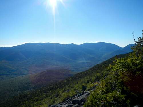
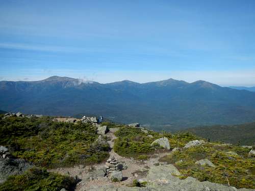
![Carter range from Daniel Webster trail]() Carter range from Daniel Webster trail
Carter range from Daniel Webster trail![Mount Washington and Adams from Mount Madison]() Mount Washington and Adams from Mount Madison
Mount Washington and Adams from Mount Madison
From the hut, we took the Star Lake trail 1 mile to the top of Mount Adams (5774'). The Star lake trail is a beautiful trail that ends with some fun scrambling just below the summit. We were now well above the clouds which made for some great views. We chose to stop for a 10 minute break and enjoy the scenery. Mount Adams, to me, was the best summit on our hike. It offers steep terrain / scrambling and a great 360 degree view which includes the wildcats, the carter range and the northern part of the presidentials. From Adams, we descended 0.3 miles to the next junction and took the Gulfside trail towards our next summit, Mount Jefferson (5712'). Mount Jefferson is 2.2 miles away from the summit of mount Adams but to get there, the slopes are a lot more gradual compared to those of Madison and Adams. The only challenge is the boulders that make up the trail but that is typical of the presidential range. 0.4 miles from the summit, we exited the Gulfside trail and took the mount Jefferson loop trail. The summit of Jefferson is a bit of a weird one. Once on top of the "main summit"/mountain there are 2 or 3 little 25 to 50 foot hills. All we had to do is to get on top of the highest one and "voila!" our third summit of the day was is the bag. Slightly stunned by the bizarre finish to this mountain, I hurried to take a picture of Grant (he did the same with me) and we were on our way to the big one, mount Washington.
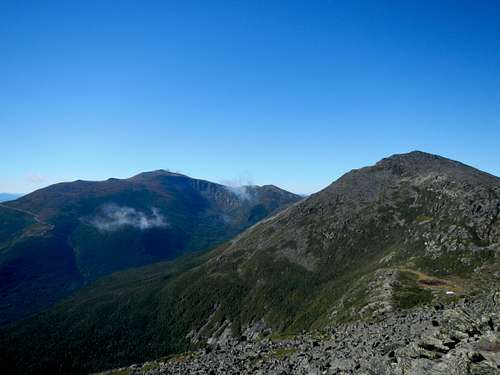
![Mount Washington from Mount Adams]() Mount Washington from Mount Adams
Mount Washington from Mount Adams
We descended back to the Gulfside trail and headed to mount Washington which is 3.1 miles from mount Jefferson. Running a bit later then we had hoped for, we bypassed mount Clay which more or less marks the half way point to Washington from Jefferson. The mount Clay loop adds only 0.1 mile to the trip and it's about 200' of elevation gain more then bypassing it. If you have plenty of time left and feel like adding to the challenge, go ahead and do mount Clay but don't complain on mile 40 of this loop that you are tired :) . About a mile from mount Washington, the Gulfside trail runs parallel to the Cog Railway. I had a fun time taking pictures of the people inside taking pictures of me and sticking my thumb out seemed to make the poor people that couldn't hike up and down laugh. Once the Cog got passed me it was back to business. A half mile from the summit, the trail does a couple of zig zags and got Grant irritated. ''Why can't they just make the trail go straight to the top!'' he yelled. And I laughed. For hiker that like to be alone, mount Washington is a nightmare. The summit includes 4 or 5 building and on this day, many jacket wearing people that said we were crazy for only wearing a t-shirt. On a good note, the views from the top are spectacular, the chilli dogs at the canteen are delicious and they have running water to refill our water bottles. There was a line up for a picture in front of the famous mount Washington sign. Again being short on time, we took a picture with a bunch of people in the background and ran in the canteen for our chilli dogs which were waiting for us.
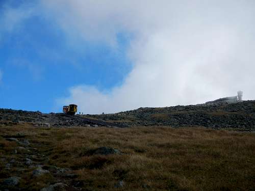
![Cog railway coming down Mount Washington]() Cog railway coming down Mount Washington
Cog railway coming down Mount Washington
![Mount Washington summit photo]() Mount Washington summit photo
Mount Washington summit photo
It was now already 3pm when we finally finished eating our chilli dogs but we knew that from this point on, it was mostly downhill to Nauman tent sites. We both hit the bathroom and refilled our water bottle before hitting the trail again which now, south of mount Washington, is called Crawford path. We descended more then 1000' feet over one and a half miles before reaching the Lakes of the clouds hut. At over 5000' above sea level, Lakes of the clouds hut is beautifully place between two small lakes in the col between mount Washington and mount Monroe. This would make a great spot to kick back, relax and enjoy life in the mountains and, located only 3.1 miles from the Ammonoosuc parking lot, makes for a relatively easy hike to get there. Grant and I walked right passed the hut not even taking the time to have a look inside. We ideally wanted to make it to the tent sites before sundown and had to make good time to make it happen. From the hut we then took the mount Monroe loop 0.3 miles to the summit of peak number 5, Mount Monroe (5372'). Again, on a tight schedule, a lady took a picture of us on the summit and we were on our way back down toward the Crawford path and mount Eisenhower (4760'). There are 2.2 miles separating mount Monroe and mount Eisenhower and once again we had to take the detour loop to the later summit. A picture, water and a small snack were in order for the final push of the day. Mount Pierce (4310') was the next peak on our list and also the 7th and final summit for the day. 1.6 miles separates mount Eisenhower from mount Pierce and then 0.9 miles from Pierce to Nauman tent sites.
![Grant and I on top of Mount Monroe]() Grant and I on top of Mount Monroe
Grant and I on top of Mount Monroe
We arrived at the tent sites at 6:30pm with a little more then a half hour left of sunlight. We had been hiking for almost twelve hours, 17.4 miles and more the 8500' of elevation gain were behind us. We went to see the tent sites caretaker which assigned us to a tent platform. We set up the tent while boiling some water for our meals and by darkness we were having dinner. The Nauman tent sites are brilliantly located beside the Mazpah hut which allows you to use the facilities, all between a reasonable time of day (don't go in the hut at midnight looking to buy food, refill water, use the washroom or even breath. That's right! Don't even look at to the hut from more the 50 yards you cheap hiker who wanted to save money by using the tent sites!...sorry, got carried away there). We hit the sleeping bag by 8:30 knowing day two had the potential to be just as long.
Day 2
Our alarms woke us up at 5:30 and the slightest sunshine glow greeted us once we got out of the tent. We had an oatmeal breakfast and drank down a full liter of water. Being so early, and having neighbours on adjacent tent platforms, we chose to hike up mount Jackson (4052') first, then break down camp, pack our bags and get on our ways for the rest of the day. Now my biggest regret of the trip was to leave my camera at the tent site during this 3.4 mile round trip. From mount Jackson, the views are absolutely spectacular, at 7:30am anyways. Looking at mount Washington, one big cloud, the only one around, was rising up the valley a barely making it to the east side of the mountain. It had an umbrella like shape where, if you stood at a specific point on the slopes of mount Washington, you would find yourself wrapped in this cloud while at the same time have a views of the valley and the underside of the cloud. It looked very much like a lenticular cloud that tried to make its way on top of the ridge but never really got there. Again, bring your camera, you'll never know what you'll see.
We got back to our tents, packed everything up, refilled on water and headed down the Dry river cutoff trail. This trail links the Mizpah hut and the Dry river trail (Dry river cutoff and Dry river trail are two different things). The Dry river cutoff must be vary rarely used and we quickly went from rock hoping to dirt trail with trees touching both shoulders in a matter of minutes. After 2 and half miles we reached the Dry river trail and followed it south 0.3 miles to Isolation trail. At about the junction of the two trails, we meet our first soul of the day and he was heading to mount Isolation as well. We were told that the trail had just recently re-opened after being washout by heavy rains and the damage was obvious to see. At times, the trail was harder to follow but nothing that would get anyone lost. After travelling 2.4 miles uphill on Isolation trail, we reached the junction to Davis path. We dropped our packs at the junction and continued southbound for 1.2 miles to our ninth summit of the weekend, mount Isolation (4004'). From the junction, at about 4200', it is mostly a down climb to mount Isolation for the exception of the last quarter mile which then goes uphill to the summit. Weirdly enough, on the summit of mount Isolation out of all places, we meet this man which is, like Grant and I, an Adirondack 46er and that we had met walking out of our Pemi loop adventure. It still blows my mind to think that the only Adirondack 46er we saw on the Pemi loop was also, three months later on the top of mount Isolation on the same day and at the same time as us. It truly is a small world even when surrounded by giants.
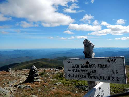
![Glen boulder trail sign]() Glen boulder trail sign
Glen boulder trail sign
From the summit of Isolation we headed northbound back to our packs and took a food and water break. We then took the Davis path 1.6 miles uphill to about 5200' to the junction of the Glen boulder trail. The scenery on the Glen boulder trail is great but the positives stop there. Its a long 3.2 miles down nearly 4000' back to Pinkham notch over knee breaking boulder and just when you have enough of big boulders, the Glen boulder appears just to make you sick to you stomach. Thinking back on it, the position in which and where the Glen boulder stopped going down hill is quite fascinating but again not the time nor place for such a big boulder.
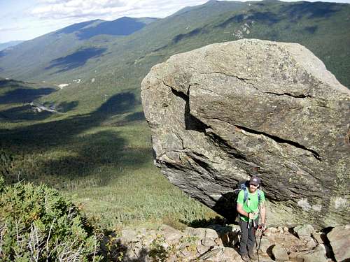
![Glen Boulder]() Glen Boulder
Glen Boulder
We finally reached our bear barrel at Glen Ellis falls at 4:30pm. We crossed under, yes under, the highway 16 and had dinner by the Glen Ellis river. We drank lots of water and refilled our water bottles with Grants lightweight water filter. At 5:15 we were on our way up the steep and mean Wildcat ridge trail. The trail goes up more then 2000' over 1.8 miles before mellowing out the remaining 0.4 miles to the summit of Wildcat D. Running out of day light on our way up the ridge, we found our selves a ''stealth'' campsites away from the trail. On the way up toward Wildcat D, there are a lot of herd paths that lead you to campsites. Be sure to respect all rules in place in every conservation area or wilderness. By the time we had set up our tent, the sun was down and we were chatting about tomorrows hike.
On day 2, we travelled 16.9 miles with over 5500' of elevation gain in about 11 and a half hours. The burning legs and the 25 pound packs clearly slowed us down a little bit on day 2 but we still managed to reach our intended destination.
Day 3
At 5:30, our alarms go off, we both slowly get up from the tight muscles that were yelling "Not again!" to our brains. I've gained much respect for the folks doing long trails such as the AT or the PCT, the amount of dedication and perseverance you need to get up every morning and hike 15 to 20 miles surpasses my abilities. We had a good breakfast (again oatmeal, apple cinnamon for those who care to know) and start packing to start walking at 6:30. A half hour after our start, we reached the opened area on top of the ski hill. On this clear morning the sun was blasting the presidential range in a tint of orange which added to the glow of the morning sun. Not much further down the trail, we reached the summit Wildcat D (4050'). The summit of this mountain is covered in tree. Luckily a raised platform/ lookout was build so hikers could get a view of the presidential range from the summit. After a summit picture we carried on two miles to the top of the famous Wildcat mountain (4422'). Everything you read about the wildcats is true, steep scrambles make for slow pace and the 5 miles from Glen Ellis falls to the Carter hut feel longer then you would expect. From the top of Wildcat, you almost look 1000' straight down into the Carter notch and at the Carter notch hut and wonder "How the heck are we getting down there?!?". The trail then heads down steeply but never too steep to the point where we had to slow down at all, surprisingly. They seemed to have really thought out the path for this trail to make the 0.9 miles down to the hut as knee friendly as possible.
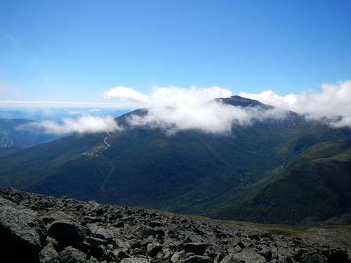
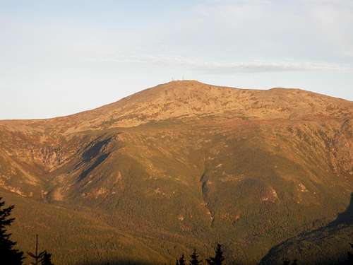
![Sunrise over Mount Washington]() Sunrise over Mount Washington
Sunrise over Mount Washington
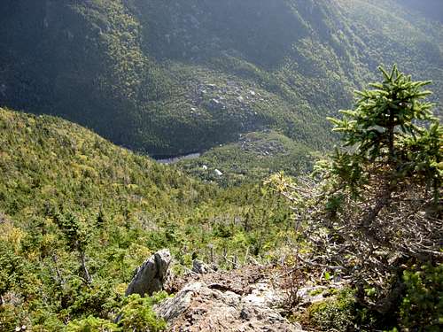
![Carter notch hut from Wildcat]() Carter notch hut from Wildcat
Carter notch hut from Wildcat
We got to the Carter Notch hut at about 9:30, had a break, a snack, refilled on water and chatted with the staff for 10 minutes or so before getting on our way. From deep down into the Carter notch, its an other steep 1.2 miles and almost 1500' of elevation gain to the summit of Carter Dome (4832'), our twelfth summit of the weekend and the highest mountain in the Wildcat-Carter-Moriah range. The summit is again, treed in and the view is very minimal so we got this nice couple to snap a picture of use on the summit and off we went. We walked down hill 0.4 miles to the junction to mount Hight and took the summit loop an other 0.4 miles to the top. Mount Hight isn't part of the AMCs 48 mountain but it is definitely worth the 0.2 mile detour and 200' or so of elevation gain. This summit offers the best views (360 degrees) you'll have all day and as tired as you may be, go to that summit even if you have to sit down for a half hour to get your energy back. After Hight, we headed down to Zeta pass. This point could make a potential bail out point if you're lacking the energy to go any further. You would take Carter dome trail to Nineteen-mile brook trail and down to the parking lot where you could easily hitch a ride back to Dolly Copp. We chose to keep going on the Carter Moriah trail 0.8 miles to the summit of South Carter mountain (4430'). Again the summit offer no views but a summit picture was still in order.
![Northern presidentials from mount Hight]() Northern presidentials from mount Hight
Northern presidentials from mount Hight
We carried on 1.3 mile north to our 14th and last summit of the weekend, Middle Carter mountain (4610'). This might be the least impressive summit on this ridge. We just ended up at a random cairn on the side of the trail which marked the summit, we both looked at each other and said "that's it?". I think both of use were disappointed that we weren't finishing this epic hike with much of a bang. None the less, it does count and it was mostly all downhill from here. We walked down 0.6 miles to the junction of the North Carter trail and took it westbound 1.2 miles to the Imp trail. The Imp is a huge cliff which looks like a face from Dolly Copp campground. If you want to have one more view and feel like having a bit more uphill added to your day, go ahead to the Imp face and let me know how it was. We chose to take the easier / more gradual downhill but 0.1 miles longer southern section of the Imp trail which bring you to the 16 a stones throw south of the northern parking lot. At 3:50 we finally reached highway 16. The sights and sounds of cars passing by felt strange but the relief of knowing a sit down meal was only minutes away was definitely was I remember most stepping onto the asphalt.
At this point, Grant had been suffering from knee pain for at least a couple of hours. We started to walk up the road when, at the Imp north parking lot, a father and son duo popped out of the trail and started walking to their car. "Do you want to ask for a ride?" I asked. "Yes!" was the only word that came out of Grants mouth. We crossed the road and offered food, candy and even a car wash but they ended up just giving us a ride to Dolly Copp for free :) . I really do feel bad however because I know that smell won't come out the backseats fabric very easily. We reached our car at 4, drove down to Glen Ellis falls to retrieve our bear barrel and the back north to a warm, cozy Gorham restaurant.
On this third and final day, we hiked a total of 13 miles and about 6000' of elevation gain in 9 and a half hours. The Wildcat-Carter range was a tough as we had read and the wildcats are definitely wild.
Tips, pointers and conclusion
TIPS AND POINTERS
- The Presi-Carter loop is the next step up from the Pemi loop. Grant and I had a blast figuring out trails to make this loop happen and organising our trip. Make it your own and know the map inside and out to understand all your options at every point along the loop.
- I strongly suggest caching a bear barrel at the end of day two or plan a trip to the Pinkham notch visitor center to refill on food. Saving a days worth of food in weight makes a big difference over 30 miles.
- Refill your water bottles at every opportunity and plan accordingly.
- Have a chilli dog on the summit of mount Washington.
- Naumans tent sites are 10$ per person
- Don't drive to Maine
CONCLUSION
The whole Presi-Carter loop ended up being 47.3 miles long with over 20,000' of elevation gain, yes 2-0-0-0-0 feet over 14 of New Hampshires 48 4000' peaks. We walked for a total of 33 and a half hours over 3 days (12-12-9 and 1/2) and burnt too many calories to count thanks to the help of our 22 to 25 pound packs. It was before all a great adventure, with a great friend and hiking partner and I hope everyone gets the chance to experience something like this regardless of the activity you're into. Feel free to ask any questions about the loop.
Comments
No comments posted yet.