The main routes of Aiguille de la Grande Sassière, Rutor, Grande Rousse, Monte Berio Blanc and other

-
 3359 Hits
-
 79.78% Score
-
 11 Votes
|
|
Route |
|---|---|
|
|
45.63558°N / 7.02109°E |
|
|
Mountaineering, Trad Climbing |
|
|
Spring, Summer, Fall, Winter |
|
|
Overview
This page concerns the offshoots most Southern respect Mont Blanc. Comprises the next Valleys of La Thuile and adjacent Valgrisenche. Among these they stand out the Grande Assaly (3.174m) more to the West, the Testa (Head) of the Rutor (3.486m) in South, Mont Paramont (3.301m) into a central basin, while from the Great Sassière (3.751m), at the end of Valgrisenche, down towards the North the watershed with the valley of Rhêmes reaching the double pyramid of the Grande Rousse (3.607m). A series of mountains not too difficult, but never banal and dull, much less to be underestimated. Also they mark the point of the border between the Western Graian (Mont Blanc) and the Oriental Graian relaxing and stretching to the Tarentaise Val d'Isère into the France (South) and the following Piedmont Region (Southeast). A circle of mountains of which the waters descend to the North in direction of the Baltea in the middle of the Aosta Valley. In practice this group of mountains is inserted between the Mont Blanc Chain (4.811m) in the Northwest and the Gran Paradiso (4.061m) to the southeast.
Questa pagina riguarda le propaggini oltre la Catena del Monte Bianco. Quindi comprende le successive Valli di La Thuile nonché l'adiacente di Valgrisenche. Tra queste si distinguono la Grande Assaly (3.174 m) più spostata verso Occidente, la Testa del Rutor (3.486 m) spostata a Meridione, il Mont Paramont (3.301 m) nel bacino centrale dominante il corso della Dora Baltea, mentre dalla Grande Sassière (3.751 m), proprio in fondo alla Valgrisenche, scende verso Settentrione lo spartiacque con la Valle di Rhêmes raggiungendo la duplice piramide della Grande Rousse (3.607 m). Una serie di montagne non eccessivamente difficili, ma mai banali e tantomeno da sottovalutarsi. Inoltre segnano il punto di confine tra le Alpi Graie Occidentali (Monte Bianco) e le Graie Orientali che si distendono verso la Tarentaise e la Val d'Isère in Francia (Sud) ed la viciniora Regione del Piemonte (Sudest). Un circolo di montagne le acque delle quali discendono verticali verso Settentrione in direzione della Dora Baltea al centro della Valle di Aosta. In pratica questo gruppo di montagne si trova inserito tra la Catena del Monte Bianco (4.811 m) a Nordovest e quella del Gran Paradiso (4.061 m) verso Sudest.
First ascents
Aiguille de la Grande Sassière (3.751m):- W. Mathews and M. Croz, (Aug 05th, 1860).
- R.C. Nichols, E.P. Rowsell, J.V. Favret, M. Brunod and companions, (Aug 13-14th, 1864).
- Jacquemod from italian, Col Tachuy, side (Sep 1878).
- Piero and Delfino Perrod, (? Date ).
- Nicodemo Jadanza, (Aug 1880).
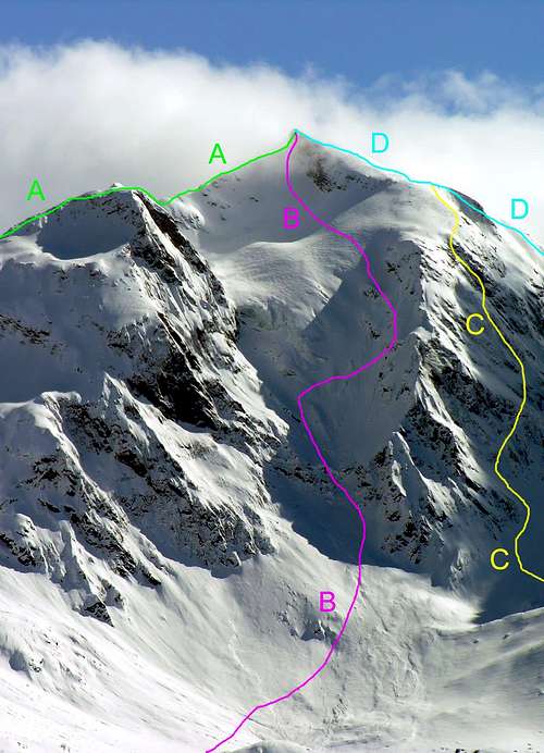
Route Description
|
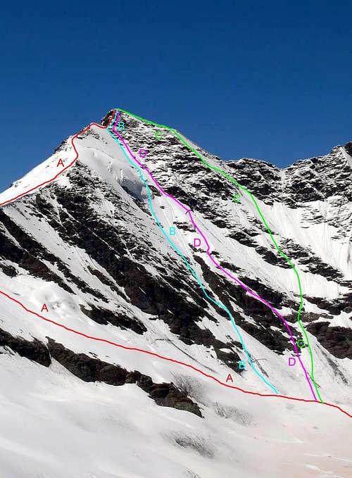
A) = SE ridge: W. B. A. Coolidge and Chr. Almer (father and son), (Aug 06th, 1878). Difficulty: AD+.
B) = NE Wall serac route: Cleto Frassy and Danilo Garin, (? Jul, 198?). Difficulty: D+.
C) = NE Wall: Aldo Bonacossa and L. Hosquet, (Jan 30th, 1917). Difficulty: AD+. Length: 650m.
D) = N-NE Wall (Direct route in descent): Osvaldo Cardellina, Camillo Roberto Ferronato and Giuseppe Lamazzi, (Aug 24th, 1980).
|
|
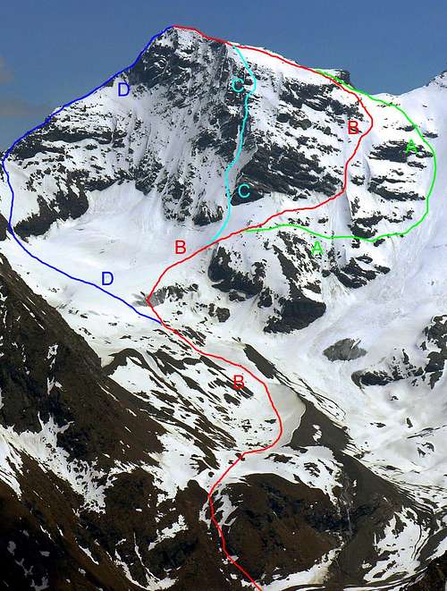
A) = From Invergnan Glacier: J. V. Favret, M. Brunod, R.C. Nichols, E. P. Rowsell and companions, (Aug 13-14th, 1864). Difficulty: PD+/AD.
B) = N-W Buttress: W. B. A. Coolidge and Chr. Almer, (Aug 25th, 1885). Difficulty: PD+.
C) = N Wall: Danilo Garin and Alberto Sciardi, (Jul, 1980). Difficulty: AD+/D. Length: 600m.
D) = From Mont Forciaz Glacier: F. Vallino, G. B. Bich and A. Castagneri, (Jul 30th, 1885). Difficulty: III°/IV°.
|
|
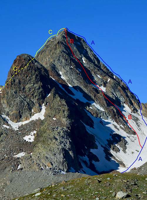
A) = SW Side: Piero end Delfino Perrod (? Date). Difficulty: F.
B) = W Side: G. Bobba and C. Thérisod, (Aug 23th, 1896). Difficulty: PD+.
C) = NW Wall: G. Dumontel, lone, (Jul 05th, 1902) in descent. Difficulty: PD+. Length: 400m.
D) = N Ridge: ??? (1896). Difficulty: III°/PD+.
|
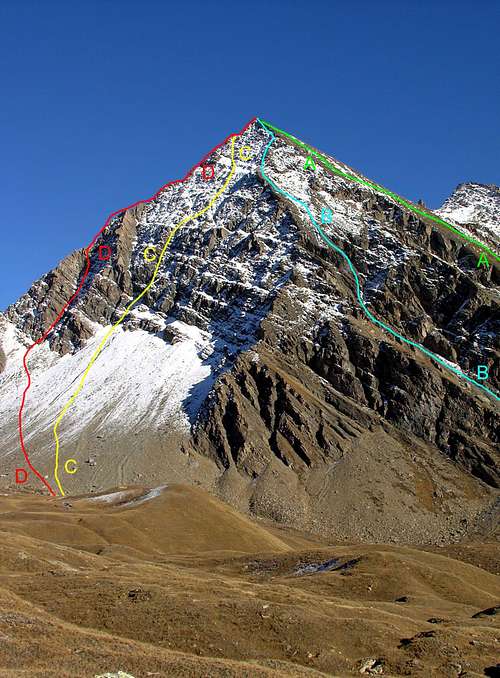
Route Description A) = N-E Arête: Emanuele Andreis, Luigi Bon and E. Denina, (Aug 03th, 1927). Difficulty: AD-.
B) = Wall N: Pino Formento, Eugenio Bochet and Cesare Quey, (Aug 10th, 1939). Difficulty: AD/D-.
C) = N-NW Wall: Osvaldo Cardellina, lone, (Jul 27th, 1999). Difficulty: AD-/AD.
D) = N-W Arête: Nicodemo Jadanza, lone, (Aug 1880). Difficulty: F+.
|
Essential Gear
Complete alpine equipment.Attrezzatura alpinistica completa.
Refuges and Bivouacs
- Rifugio ALBERTO DEFFEYES
- Rifugio DEGLI ANGELI ex Scavarda
- Rifugio MARIO BEZZI
- Rifugio CHALET DE L’ÉPÉE
- Bivacco LUIGI RAVELLI Invergnan (2.860m)
Books and Maps
BOOKS:- "Guida delle Alpi Occidentali" di Giovanni Bobba e Luigi Vaccarone C.A.I. Sezione di Torino Volume II (parte II) 25-05-1896.
- "Guida della Regione Autonoma Valle d'Aosta" di Mario Aldrovandi, Ed. S.P.E. di Carlo Fanton Torino 1964.
- "80 itinerari di Escursionismo Alpinismo e Sci Alpinismo in Valle d'Aosta", di Osvaldo Cardellina, Ed. Musumeci, Giugno 1977 (in Italian); seconda Ed. Luglio 1981; terza Ed. Luglio 1984; (in French), prima Ed. Febbraio 1978; seconda Ed. Marzo 1980.
- "Guida dei Monti d'Italia Alpi Graie Centrali" di Alessandro Giorgetta - Club Alpino Italiano-Touring Club Italiano, 1985 (in Italian).
- "Ascensioni 1964-1969" Diario Alpinistico di Ilario Antonio Garzotto (unpublished).
- "Diari Alpinistici" di Osvaldo Cardellina e Indice Generale accompagnato da Schedario Relazioni Ascensioni 1964-2019 (unpublished).
 |
 |
 |
 |
 |
 |
MAPS:
- Kompass "Massiccio del Monte Bianco Valle d'Aosta" sentieri e Rifugi Carta turistica 1:50.000.
- Kompass "Gran Paradiso Valle d'Aosta" sentieri e Rifugi Carta turistica 1:50.000.
- L'Escursionista "La Thuile-Piccolo San Bernardo" Carta dei sentieri (n° 2) 1:25.000.
- Enrico Editore Ivrea-Aosta "Gruppo del Gran Paradiso" 1:50.000.
- I.G.M. Istituto Geografico Militare Maps 1:25.000.