THE CHALLENGE
This story takes place four months after my friend and climbing
partner Gary Sohler broke his femur and destroyed the nerves in his leg, leaving him with a drop-foot condition (unable to actuate the muscles in his lower leg), and one year and four months after I broke my femur, fortunately with far less severe consequences. Climbing this peak was a bittersweet victory of sorts.
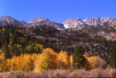
An early freeze sets the aspens ablaze at North Lake.
I had been challenged.
I finished my coffee ritual and sat in the North Lake campground. An early cold spell had turned the aspens a bright yellow, but this morning was balmy and breezy...a perfect excuse for laziness.
To Gary, I said "I think I'll go hike up the pass today...maybe climb a peak..."
"No way! It's 10:00 already. You're crazy!" he said.
Gary prepared his fishing gear and lunch for a jaunt to the lake.
"It's not that far...I don't know...maybe I'll climb something on my way up."
"It's seven miles to the pass, isn't it?" he asked.
"Naw! Only five," I replied.
"How much you wanna bet you don't make it?"
"Hmmmm....."
"C'mon! I'll bet you that even if you climb something, you won't be back til after dark." Aha! The challenge!
"Well," I said, "I don't think I want to bet you anything, but I'm gonna try anyway, and you'll see..."
Gary gives me a look of doubt. He gets into his wheelchair and hitches up the dogs. With a sharp "HA!" he is under way, leaning up on 2 wheels as he careens from the campground in a could of dust.
I brushed off my lazy mood and packed up for the drive down to the lake. I would leave the truck - and the supplies it contained - with Gary for the day. 'I hope he doesn't try to drive anywhere...' I thought.
I left Gary the keys and wished him good fishing. By 10:30 I was marching out of the
trailhead parking and back up the road to the Piute Pass Trail.
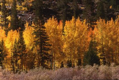
Fall colors
Once I was on the trail, I had the beautiful aspen forest all to myself. I strode quickly up the trail, taking occasional breaks to gawk at the nearby Piute Crags, a tremendous line of orange towers far above the trail. I reached a set of switchbacks and saw that I was about 1/4 mile behind another hiker. I kept up my pace and soon caught up to the hiker resting on a rock. We talked while resting there, then I continued ahead, anxious to get up the pass.
The next stretch of trail was remarkable. The switchbacks ended and the trail contoured to the east and toward the base of a cliff band blocking the canyon. A short traverse across the base of the cliffs lead to a chute leading up between two immense granite outcrops.
Above the cliffs was Loch Leven, the first lake I encountered since leaving North Lake. Just below the lake was a beautiful reflection pool ringed with symmetrical rock formations.
As I continued up the trail, I could see a small wooden structure to the east, just above a lake. It looked like either a new-fangled solar outhouse, or a very small, cramped patrol cabin. I never got close enough to tell.
Further up the trail, I encountered a few people coming down from the pass and a few more just setting up camp. I passed them by and kept trudging...
The pass itself is a broad saddle of nearly solid white granite, with meadows laid out on benches here and there. The wide views down into the Humphreys Basin were beautiful.
I rested on the pass for a while, then headed south toward the rounded ridge on that side of the pass. I climbed over broken rock to the top, where I found a wide bench with many small tarns. Further south, across the bench, I saw a hogbacked ridge with a broad band of slabs at its base. The ridge led up from left to right toward a diamond-shaped plateau high above.
This ridge beckoned, and I just couldn't resist. I walked across the bench toward the slabs at the base of the ridge. I climbed a system of easy cracks up the low-angle slabs, aiming for the start of an indsitinct rib of talus leading up this side of the ridge.
After I climbed the slabs, I sat on a nice rock and took a break. While I sat there, dozens of small birds began to fly down the slope around me. They were moving very fast. I looked around, and saw the cause of their agitation. They were chasing a hawk for some reason. No matter how hard it tried, the hawk couldn't escape the harrying little birds.
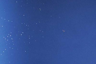
Swifts chasing a hawk at 12,000 feet.
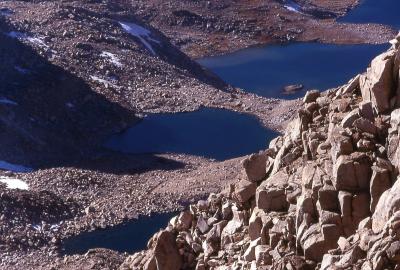
Finishing my snack, I packed up and kept climbing. I was now on the talus rib leading to the crest of the ridge. I climbed up until the talus rib disappeared into the face. Traversing north, I gained a small notch on the crest of the ridge. I scrambled to the small bump north of this notch, and found myself teetering on the brink of a sheer 1000 ft drop into Piute Lake. I could see the forms of the canyon bottom below the surface of the lake, tinted blue-green by the water.
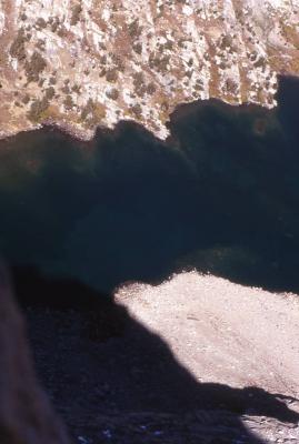
A view down into Piute Lake.
Now I was right on the crest of the ridge, climbing over steep talus. The angle of the ridge began to ease, and I found myself traversing the long hogback toward the point where it connected with the higher diamond plateau. The ridge top was mostly talus, but there were some sections where I was walking a solid 3-4 ft wide catwalk with a 1000 ft drop on the left and a 60 ft drop on the right. It wasn't difficult, just ennervating.
I descended a little to a notch just below the diamond plateau. Here, too, I had to traverse another catwalk with hundreds of feet of steep slabs dropping away to the left, and very steep talus slopes dropping to the right.
I crossed the notch, only to be confronted by a steep wall of talus, which turned to cliffs on its left side. I climbed up and right, then up and left, and regained the crest a few yards below the plateau. Once I was on the plateau, I walked across the gentle, sandy slope to the opposite end. Here, the plateau tilted upward and narrowed to a point of talus, with another precipice to the left and very steep talus and ledges to the right. From this point,
I was looking down into a scary notch and across to a turret of jumbled blocks. What now?
Carefully examining the rib of talus leading into the notch, I picked what looked like a possible route. I climbed down, winding between spikes and blocks, and made it to the narrow notch. This place was scary! The broken ledges falling away to the right looked dangerously loose, and the slabby chute to my left dropped about 100 ft before emptying into space. The turret loomed before me like a shattered building.
I climbed up a set of ledges covered with debris, working around the right (west) side of the turret. The going got easier, but looser, the closer I got to the top. I made it to a loose mini-notch atop the turret and turned left for the final few yards to the summit. The summit block was a stout cubic mass sitting on the northern corner of the turret. I crawled out to its edge and peered down into the void. I was so gripped, I didn't even care to stand up.
The views from this summit were awe-inspiring, with Mt. Humphreys and the Humphreys Basin dominating the views to the north, Muriel Peak close to the southwest, and an unnamed peak very close by across a deep notch in the ridge. Behind this peak, the Inconsolable range and the northern peaks of the Palisades could be seen.
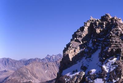
Peak 13,120' and the distant Inconsolable Range.
Just to the northeast, and immediately below the peak, I could see the deep blue pools of the Lost Lakes.
The Lost Lakes below Muriel Peak.
While I was on the summit, I tried in vain to get a self-portrait with Mt. Humphreys in the background, but I nearly killed myself when I set my camera timer and tried to scramble quickly into position. I tripped on a loose rock and almost cartwheeled down the west face of the turret. I settled for this glorious panorama of Mt. Humphreys and the Humphreys Basin. Bear Creek Spire is the tall grey peak on the left skyline in this picture. The summit block of my peak is in the right foreground, and the edge of the diamond plateau is in the left foreground.
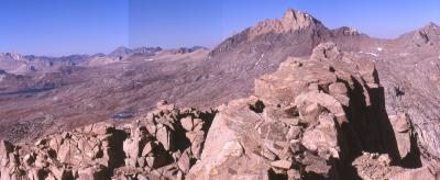
Humphreys Basin and Mt. Humphreys - Panorama.
I stayed about half an hour on the summit, then headed down. I made it back to Piute Pass by 4:30, and, nearly running, made it back to North Lake by dusk, where I related the tale, with much pride, to Gary, who had just finished an unsuccessful day of fishing on the lake. Too bad...
FIN!
Comments
No comments posted yet.
