
|
|
Mountain/Rock |
|---|---|
|
|
36.10000°N / 81.82°W |
|
|
Avery |
|
|
5964 ft / 1818 m |
|
|
Quicktime panorama
TanawhaPanoramas.These photos and movies are by the owner/maintainer of the mountain and are of the trailhead at the swinging bridge as well as various peaks.
Overview Including MacRae Peak Link
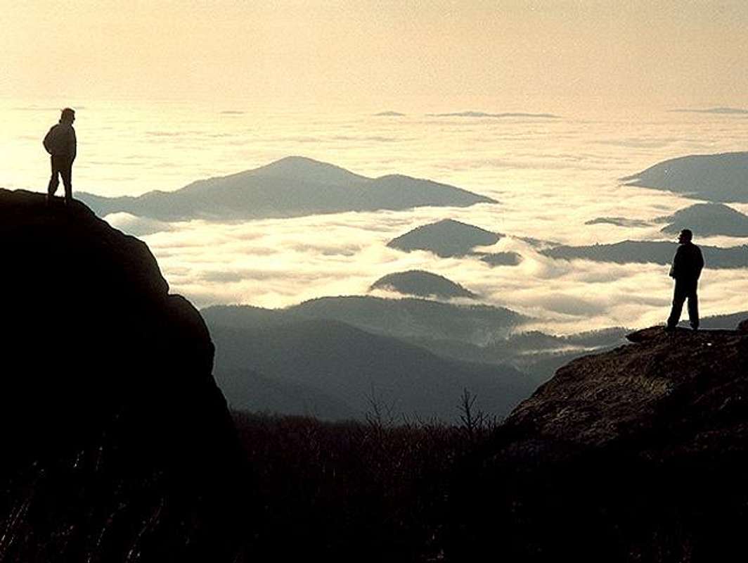
Tanawha-Hawk Mtn in the Cherokee language or Grandfather Mtn. is the highest point in the Blue Ridge. The interested reader can go directly to the most exposed summit block at MacRae Peak
The Blue Ridge Parkway traverses it over some amazing viaducts. Unlike many elevations in the Southern Appalachians it is fairly rugged.
The summit consists of a gigantic boulder which is accessed by a ladder. It is one of the most popular mountains in the U.S. There is a gift shop and the mile high swinging bridge out to one of its sub peaks.The pink shell azalea is to be found only on its slopes. Andre Michaux an 18th Century Botanist was the first to record an ascent to wit we have some diary entries from 1796:
August 21.-Reached the summit of (Roan) Mountain; found in abunda small shrub with boxwood-like leaves I formerly designated as Leiophullum folium, but the capsule of which has three and opens at the top.*

[It is strange that Michaux did not mention the abundanceof this shrub growing on the bare rocks of Grandfather Mountain.]
August 22.-Reached the summit of the Yellow Mountain.
August 23.-Returned to Davinport's house.
August 24.-Put my collections in order.
August 25.-Rain.
August 26. Started for Grandfather Mountain, the most elevated of all those which form the chain of the Alleghanies and the Appalachians.
August 27.-Reached the foot of the highest mountain.
August 28.-Climbed as far as the rocks.
August 29.-Continued my herborizations.
August 30.-Climbed to the summit of the highest mountain of all North America, and, with my companion and guide, sang the Marseillaise Hymn, and cried, "Long live America and the French Republic! long live Liberty! etc." Le 30 Monte au sommet de la plus haute montagne de toute l'Am. Sept. et avec mon compagnon Guide, chante' l'hymne des Marseillais et Crie' Vive l'Ame'rique et Ia Re'pubh'q. Fran~aise, Vive la Liberte', etc., etc.
August 31.-Rain all day. Staid in camp.
The last portion of the Blue Ridge Highway was the Linn Viaduct. The Mortons donated the land where the highway crosses the mountain slopes and an award winning viaduct was created to minimize the construction effect to the mountain.
 |  |
Wounded Knee noted the Cherokee meaning of Hawk Mountain
Getting There
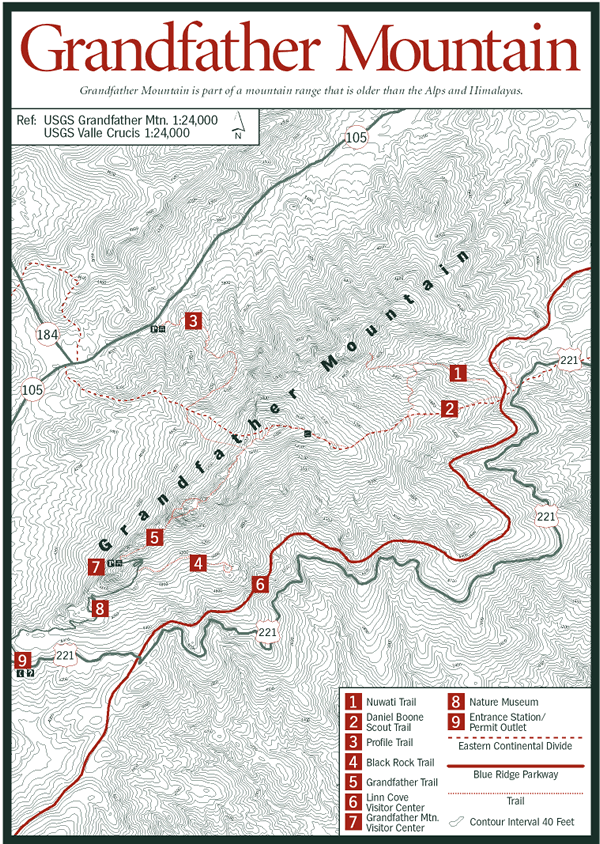
U.S. Highway 221 out of Linville North Carolina just a few miles to the northeast. One may also visit from Boon N.C. and drive down the Blue Ridge Parkway by and onto Tanawha. It is les than 100 miles to Charlotte because I saw a picture of the Charlotte Skyline taken from the Mountain. The Skyline was rising above the morning fog.The Tanawa Trail (no fee) runs parallel with the Blue Ridge Parkway. There are many parking lots/overlooks between the Linville exit and the Moses Cone Park to access this trail. One of them is called Rough Ridge Overlook and a short hike of aprox 10 minutes gets you up to some board walks. In May/June the Catawba Rhododendons are blooming. The RR trails leads right through plenty of Rhododendron fields. From the board walk you will have gorgeous views of Grandfather Mountain and into the Wilson Creek area / Pisgah National Forest. The elevation drop on this side of Grandfather Mountain is about 4500 ft. An other 10 minute hike from the boardwalks will get you up to a granite boulder for more unforgettable views.
Red Tape
The mountain is under private ownership and closes in the evening. You must pay an entry fee and leave by sundown.Access Via Automobile Through Main Gate)
828-733-4337 Gate -- 800-468-7325 Office
Adult 13-59 $14
Senior 60+ $12
Child 4-12 $6
Children under 4 Free
Hours
(Ticket Sales End One Hour Before Closing)
We recommend you arrive before 11:00 a.m. or after 3:00 p.m. on summer weekends, holidays and fall color weekends. You'll move through the Gate more quickly, there will be fewer people in the park, and the animals will be more active. If you can only schedule your visit for midday, we will always be ready to take care of your travel party.
If you are a resident of Watauga or Avery county you are able to enter the park in the month of April and December for $1.00/person. Rangers are checking proof of residency. This last was posted by Gumpie
When To Climb and Weather too
Any time of year-but watch the wind in the winter- and I expect it ices up in the winter. On January 24-25, 2006 a gust of 200 mph was recorded. Prior wind records include 196 mph. alt="Click for Banner Elk, North Carolina Forecast" height=50 width=150>
 |
Camping
You may camp in nearby Linville Gorge. But here are some other options from the Blue Ridge Parkway: Places to Stay:Campground - The largest campground on the Parkway is located at Julian Price Memorial Park (milepost 297.0). It has sites for 129 tents and 68 trailers. Facilities include water, comfort stations with flush toilets and sinks but no showers or hook-ups. Several sites are handicap accessible.
Other lodging - Several motels and bed-and-breakfast inns are located in or near Boone and Blowing Rock (exit at milepost 291.8 or 294.6).
Places to Visit:
Visitor Center - A visitor information desk, bookstore, and craft center are all located in Flat Top Manor (milepost 294.0). Linn Cove visitor center (milepost 304) features a model of the Linn Cove Viaduct, an engineering marvel and the last section of the Parkway completed.
Picnic Area - The Price picnic area (milepost 296.4) has 100 sites and handicap accessible comfort stations.
Cone Park - In addition to the historic manor house, there is a family cemetery, carriage barn and apple barn. Interpretive talks are frequently given during the summer on the steps of Flat Top Manor.
Parkway Craft Center - The Southern Highland Craft Guild operates the Parkway Craft Center inside Flat Top Manor that features contemporary and traditional mountain crafts as well as demonstrations by Guild craftsmen during the summer months. For further information call (828) 295-7938.
Things to Do:
Interpretive programs - There is a 300-seat amphitheater located at the Price Park Campground (milepost 297) where interpretive talks are given during the summer months. Interpretive talks, demonstratons, and guided walks are also given throughout the Cone and Price Parks during the summer months.
Trails - The Cone/Price area has more trails than any other developed area on the Parkway. There are more than 26 miles of historic carriage roads for hiking and horseback riding on the Cone estate. The Cone Carriage Trails range from easy to moderate. Several strenuous trails can be hiked within Price Memorial Park. Price Campground offers direct access to three trails, including the ingeniously engineered Tanawha Trail, total length 13.5 miles, half of which is on Grandfather Mountain. The five-mile strenuous Boone Fork Loop Trail is accessible from both the campground and the picnic area.
Fishing - There are several fishing opportunities in the Cone/Price area. Anyone with a valid Virginia or North Carolina fishing license is welcome, but please check at the visitor center or at Price Campground for any special regulations.
Canoe/Boat Rentals - During the summer months, there is a boat dock located on Price Lake at the campground. No motorized craft or sailboats are permitted.
Mountain Conditions
TanawhaCamMaCrae Peak
MacRae PeakPilz8 has a nice page on the most exposed summit of Tanawha pictures of his excursion. Quite a few of the Tanawha pictures are of this summit area as well since it is the boldest.
Hiking Map
Prominence
This is the difference in height between the peak and the following contour line containing the peak: The lowest countour line encircling the peak and no higher peak. In this case it is crazy to follow, but U.S. Route 19 and 19E help a great deal. The highest point on this route is Cranberry Gap. On one side of the road is Tanawha and the other contains all the 6000 foot southern mountains. Since Cranberry Gap is 3500 feet, this leaves a prominence for Tanawha at 2400 feet.The interested reader may find Cranberry Gap at 36.1158°N, 81.9826°W
Gumpie - May 14, 2004 9:46 am - Voted 10/10
Untitled CommentIf you are a resident of Watauga or Avery county you are able to enter the park in the month of April and December for $1.00/person. Rangers are checking proof of residency.
Gumpie - May 14, 2004 6:24 pm - Voted 10/10
Untitled CommentThe Tanawa Trail (no fee) runs parallel with the Blue Ridge Parkway. There are many parking lots/overlooks between the Linville exit and the Moses Cone Park to access this trail. One of them is called Rough Ridge Overlook and a short hike of aprox 10 minutes gets you up to some board walks. In May/June the Catawba Rhododendons are blooming. The RR trails leads right through plenty of Rhododendron fields. From the board walk you will have gorgeous views of Grandfather Mountain and into the Wilson Creek area / Pisgah National Forest. The elevation drop on this side of Grandfather Mountain is about 4500 ft. An other 10 minute hike from the boardwalks will get you up to a granite boulder for more unforgettable views.
Gumpie - May 14, 2004 7:04 pm - Voted 10/10
Untitled Commentcanyon's webcam - Grandfather
MTN view
WoundedKnee - Mar 12, 2007 5:04 pm - Voted 10/10
Tanawha is Cherokee for "hawk"I'm always interested in the origin of geographical names. Don't know if anyone else is...
Eleutheros - Oct 15, 2010 10:33 pm - Hasn't voted
Grandfather Mountain State Park"The Backcountry of Grandfather Mountain is now Grandfather Mountain State Park. Grandfather Mountain Rangers will continue to maintain and patrol the trails through 2009 until the state can introduce its own staff. There is no charge to access Grandfather Mountain State Park from trailheads at the base of the Mountain, but registration is required for safety reasons." -Grandfather.com