

-
 5002 Hits
-
 73.06% Score
-
 3 Votes
|
|
Route |
|---|---|
|
|
46.47659°N / 7.75695°E |
|
|
Mountaineering, Mixed |
|
|
Most of a day |
|
|
UIAAIV+ / A0 - Glacier / Snow |
|
|
Overview
 SW Ridge is right skyline
This route is included in BERNER OBERLAND Die 100 schönsten Touren by Hans Grossen with Gaston Rébuffat. H. Lauper and M. Liniger made the first ascent on 18 July 1921. The approach to the route from the hut is over glacier and some moderately steep snow. From the Fründenjoch, the route is entirely on rock with difficulties up to IV+. The crux is a rather nasty overhang that most people agree is underrated in the guidebooks.
Approach
The starting point for the Southwest Ridge is the Fründenhütte
The approach to the hut starts on the south shore of the Oeschinensee which is reached from Kandersteg either entirely by trail, or by trail from the top of the chairlift. The time to the hut is about four hours on foot from town, or about 3 hours from the top of the chairlift.
From the hut the Fründenjoch, the saddle between the Doldenhorn (right) and the Fründenhorn (left) - imust be reached. Hike up the glacier (relatively gentle but as all glaciers with some crevasses) to the saddle – about one hour.
The beginning of the route is obvious from the Fründenjoch.
TOPO MAP LINK: .
Route Description
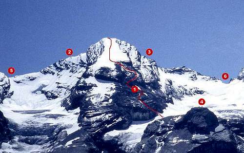 1) NW Ridge 3) SW Ridge 4) Fründenhutte 6) Fründenjoch
From the Fründenjoch a somewhat steep snow field has to be climbed. This brings one up to the rock part of the ridge. Follow the rock ridge (some slabs) for several pitches to a saddle between a prominent gendarme and the first steep section of the ridge. The gendarme is visible in the following picture. From there climb a traverse on the south side of the ridge for 1 and 1/2 pitches to a not so obvious couloir (some few bolts at this traverse). Climb up the couloir (pitons) left hand side for about 2 pitches back to the ridge. Now following the ridge on easy rock to an other steep section with is climbed in one pitch using a crack (rated III-IV). After this pitch and some other easy rock the crux of the route is reached. The crux is a "slightly" (hehehe ... ;-) overhanging area with some bolts. Belay at the bottom of the overhang and climb up (some very difficult moves or hard pulls at the bolts). This is rated UIAA grade IV+ and A0 but in my opinion this is more, maybe VI-, we were very surprised about the difficulties. (This paragraph is Stefan's description – I totally concur – this crux pitch is very difficult and almost certainly underrated. FS) After the crux simply follow the ridge up some nice pitches but easier than the rest of the route. Over all this is a very recommended route with some very nice moves. Some loose rock, especially at and below the crux. The higher one gets the better the rock quality. It is about 5-6 hours from the Fründenhütte to the summit. Descent is normally via the Northwest Ridge which is the normal route, rated PD.
Essential Gear
Rope, crampons, helmet, slings, 5-6 runners, and a small rack.
Credits
This page was originated by Stefan Weber aka kletterwebbi in 2003 and adopted by Fred Spicker in 2006. The information here is a compilation of our input and separate experiences on the route.