Overview
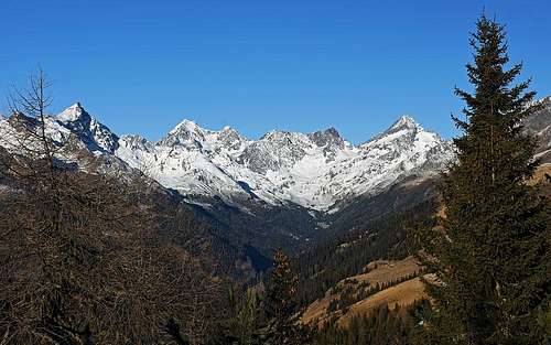
![The mountains above Debanttal]() The mountains above Debanttal
The mountains above Debanttalis far from being a majestic mountain. But if you come in the area in a winter, poor with snow, when days are short, it can be an ideal choice. It can be also ideal if you are not a demanding hiker. As some people are reaching high on the mountain with car, it is
very popular and it is very rewarding also due to really
nice panorama it offers. So, the mountain is ascended in all seasons, it offers also a few nice round tours. In normal snow conditions from the summit also a nice
ski tour goes down.
Strasskopf is the last higher summit in the ridge, which descends from the central Schober Group towards the southeast, on the Iselsberg road pass. Or, in different words, it's the first higher summit in the streak, which borders the long Debanttal on the right (looking upwards the valley).
Summit Views
![Strasskopf ascent - Lienz Dolomites]() The view on Lienz Dolomites
The view on Lienz Dolomites![By the Strasskopf cross]() Summit view - towards the Goldber group
Summit view - towards the Goldber groupA quite outposted position guarantees a nice panorama. Its most attractive and aesthetic part are for sure the sharp, much higher
peaks around the Debanttal. Towards the south we see the wonderful
Lienz Dolomites, but usually they will be shady, seen directly towards the sun. Towards the southeast we see many summits of the
Kreuzeck group and towards the northeast the closest ridges of the
Goldberg group. All these groups are divided by deep valleys, with many picturesque farms, where people are living on altitudes up to 1500 m and more.
![The mountains above Debanttal]() The mountains around Debanttal - from the south ascent on Strasskopf
The mountains around Debanttal - from the south ascent on StrasskopfGetting There
![Winklerner Alm]() Winklerner Alm
Winklerner AlmAll the main approaches are coming
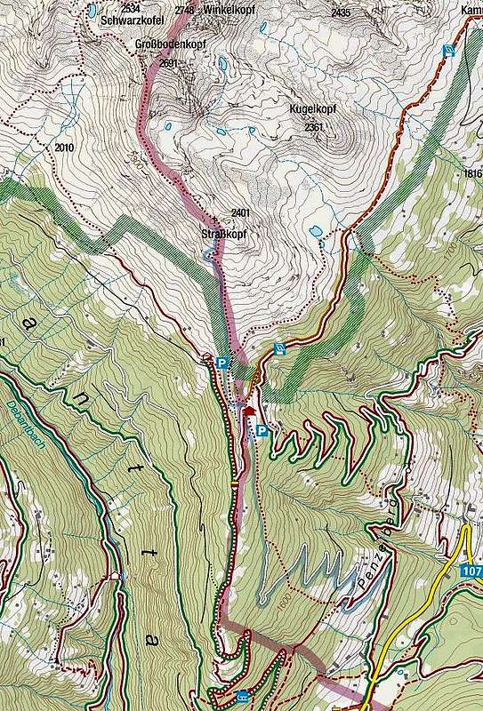
from the southern side. There are many trailheads, but all the marked paths come together on the altitude of some 1900 m, where on alpine meadows the two popular mountain huts are standing. The options are the following:
- You can start the tour on the main road, which crosses the Iselsberg Pass. You can park either on the pass, 1209 m, in Iselsberg village (south of the pass), 1117 m, or a bit above the village, at Schoene Aussicht hut, 1299 m.
![St. Benedikt]() St. Benedikt
St. Benedikt - From the Iselsberg Pass you can also drive up northwards, by a good mountain road. It goes first through the scattered hamlets of Penzelberg, reaching then the church of St. Benedikt, 1377 m. There's another trailhead. If you drive further up, you reach the road branching on good 1400 m. The road on Strasskopf alpine meadows branches left and you can park there. Or, you can pass the road barrier and drive all the way up, till the final parking place on the Winklerner Alm, 1853 m. The best option to get there is to take the 'Hohe Tauern Nationalpark Wanderbus'.
Online maps:
Austrianmap
Kompass onlineRoutes
All approach variants join on the main ridge, some 1920 m, a few minutes above the two huts (Winklerner Huette, Roaner Huette). You reach there:
1. From the Iselsberg (pass)
By the main ridge many marked paths are going up from the Iselsberg village, past the Schoene Aussicht hut and, coming on the main ridge from the east, also from the road pass. Then you ascend northwards, past a few nice panoramic points, until reaching out of the woods. The mountain road to Roaner hut goes left, to Winklerner Huette a bit more up. 2 h.
2. From St. Benedikt
A well beaten and marked path takes you up through the woods in the NW direction. After gaining almost 200 m of altitude it hits the road, coming up from the right. The path continues in the same direction, cutting the road several times and finally reaches the Winklerner Alm. 1 h 30 min from the church.
3. Southern summit ascent
From above the huts (10 min from the upper parking place) you continue in the northern direction by a nice ridge. The scenes there are great - the last larches and broader and broader views around. At first you only slowly gain altitude, when reaching the southern slopes of Strasskopf, the path starts ascending in comfortable turns. It's all the time easy, overcoming a steeper middle section by crossing the slope. Above it, the slopes are broad again and soon you are on top. 1 h 15 min, easy (T2). This is also a popular and quite easy ski tour.
4. Return via Winkler Viehalm, 1976 m
This alpine meadow (and a nice nearby lake) lies east of the Strasskopf. From the Winklerer Alm a narrow cart road reaches there, but if you want to return via that meadow when descending from the Strasskopf, you can take the marked path, which deters from the south route towards the northeast on some 2020 m. From the Winkler Viehalm you continue the descent directly down towards the southeast, reaching finally on the Penzelberg road at Kaufmann's farm, 1407 m. Then to the car at St. Benedikt.
5. To Schwarzkofelsee
In summer and autumn times a popular round tour (a bit more demanding than only the south ascent) can be done by continuing from the summit of Strasskopf by the main ridge towards the northwest. When reaching the Großbodenscharte, 2491 m, we deter left and descend steeply down to the nice Schwarzkofelsee (a small emergency bivouac there). Then we continue descending towards the southwest, until reaching on some 2050 m the well marked Wiener Höhenweg (No. 918). Then horizontally left back to Roaner Huette.
Mountain Huts
![Winklerner Huette]() Winklerner Huette
Winklerner Huette- Winklerner huette, 1906 m. 10 min from the parking place, 2 h from Iselsberg, 1 h 30 min from St. Benedikt church.
- Roaner Huette, 1903 m. 15 min from the parking place, 2 h from Iselsberg, 1 h 35 min from St. Benedikt church.
When To Ascend
![Coming on Winklerner Alm]() December, poor with snow...
December, poor with snow...The Strasskopf can be ascended
all the year, in winter depending on snow conditions. In deep snow the southern slopes can be dangerous for avalanches, even if they are not too steep. If the upper part of the mountain is icy, consider taking some winter gear. The slopes are not exposed, but the motto 'safety first' counts a lot. In winter and spring Strasskopf is also a very valuable goal of a ski tour.
Your Help Is Needed
Please add information on this page, especially:
- If you have experiences from skiing from Strasskopf
- If you have done the other routes in the neighbourhood.

 2589 Hits
 78.27% Score
 9 Votes
 The mountains above Debanttal
 The view on Lienz Dolomites
 Summit view - towards the Goldber group
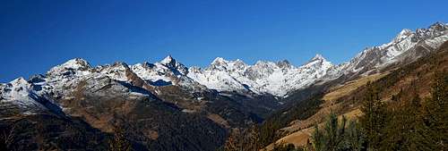 The mountains around Debanttal - from the south ascent on Strasskopf
 Winklerner Alm
 Winklerner Huette
 December, poor with snow...