Overview
![Splevta]() Splevta in front of Triglav and Stenar Splevta in front of Triglav and Stenar |
Splevta is one of the minor summits of the
Martuljek Group of the Julian Alps. It is located to the east of the group, high above the Vrata Valley, which heads from its mouth near Mojstrana to the base of the giant north face of Triglav, Slovenia's highest mountain. A close-up view will reveal that the mountain is located opposite to the curved ridge which the Rokavi, three of the taller mountains of the group form with Veliki Oltar. The cirque, which this ridge forms has Splevta at its focal point so that Splevta offers brilliant close-up views of these mountains. Moreover, Triglav, Rjavina, Stenar and Skrlatica are also perfectly visible, making the mountain a perfect look-out peak.
Access to the mountain is possible along the two valleys which are located to its
north and
south. Both valleys combine in a saddle which separates Splevta from Dovski Kriz. From there only some 20 or 30m of easy scrambling lead you to the summit of Splevta. However, this northern side is the only one to easily access the mountain. The faces in the north-east and south-west are vertical, the western one is overhanging in its topmost part while the east ridge steeply climbs from Vrata Valley towards the little meadow underneath the summit. To the south-east of the main summit on this ridge you can find a second (lower) summit, Spodnja splevta.
The whole area is only little frequented though right to the west of Splevta there is a bivouac hut in the cirque underneath the Rokavi. Moreover, our little mountain is not the main objective in the western Martuljek Group. The paths which lead to the bivouac and to the aforementioned saddle are not marked and you need good route finding abilities, especially in the lower parts of the routes where the paths run through a dense forest. All this makes Splevta a nice little mountain to take a rest and take in the scenery.
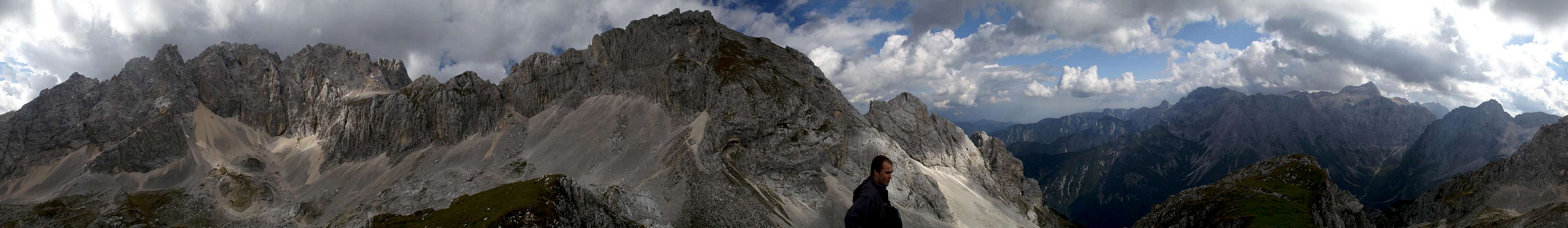
360° Summit Panorama
360° summit panorama from Splevta |
Getting There
![Splevta south face tower]() Splevta south face tower
Splevta south face tower
The trailhead for the routes to Dovski Kriz and Splevta is located roughly 1km before the end of the Vrata Valley, the entry of which lies between Jessenice and Kranjska Gora. The towns can be found in the north-west of Slovenia - not far away from both the Italian and Austrian borders.
- From Slovenia take motorway A2 to Jessenice, where you switch to 201 to Kranjska Gora. After a few kms a sign leads into Vrata Valley. Follow the road to Poldov rovt. There are a few parking places along the road and a dirt road heads up in direction of the two mountains.
- From Austria you take motorway A10 through the Karawanken Tunnel, then turn westward on road 201 to Kranjska Gora. Again, follow the signs for Vrata Valley.
- From Italy take motorway A23 to Tarvisio where you turn onto SS54 to Kranjska Gora. Switch to 201 to Jessenice and turn into Vrata Valley, following the signs.
Red Tape
Like all mountains of the Slovenian part of the Julian Alps Dovski Kriz and Splevta belong to Triglav National Park. I'm not really sure but there appear to be only very few climbing related limitations.
Accommodation
In Sava Valley to the north of the Martuljek Group you can find quite a number of hotel rooms and apartments. The following link directs to the official site of the town of Kranjska Gora:
Weather Conditions
Don't ask me why weatherunderground shows the sticker for Tarvisio when you insert the code for Ratece (5km west of Kranjska Gora) but both towns are very close to each other and they will in all probability have the same weather at all times ;-)

Maps & Books
Both Maps and books should be something our Slovenian SPers know much more about. All guidebooks deal with Spik and thus also cover Lipnica. The following list shows the books I used. Most of them are in German.
Books
- Julische Alpen
M. Podhorsky
Rother Verlag
ISBN: 3 7633 4051 3
- Julische Alpen (new edition - completely different)
H. Lang
Rother Verlag
ISBN: 3 7633 4051 3
- Klettersteige Julische Alpen
H. Heindl
Rother Verlag
ISBN: 3 7633 3372 x
- Mountaineering in Slovenia
T. Mihelic
Sidarta
ISBN: 961 6027 36 0
Maps
My map provoked ridicule by the SPers I met in Kranjska Gora so I'm not sure I should recommend it here
- Julische Alpen
Freytag & Berndt Map WK 141
ISBN: 3 85084 735 7
Scale: 1:50000

 5606 Hits
 85.87% Score
 21 Votes
 Splevta in front of Triglav and Stenar


 Splevta south face tower


Vid Pogachnik - Dec 20, 2007 3:55 pm - Voted 10/10
The ridgeHowever insignificant Šplevta looks, it is a nice ridge. You should mention that besides the main summit, 2262m, south-east of it, at the end of the long ridge the lower summit rises, named Spodnja (Lower) Šplevta. I think hardly anyone does this ridge. I read somewhere that the ascent on Spodnja Šplevta is itself a climb, but probably not harder than UIAA II. Perhaps Bor knows more.