Page Type Page Type: Mountain/Rock
Location Lat/Lon: 46.67540°N / 12.61220°E
Additional Information Elevation: 7591 ft / 2314 m
Sign the Climber's Log

Overview


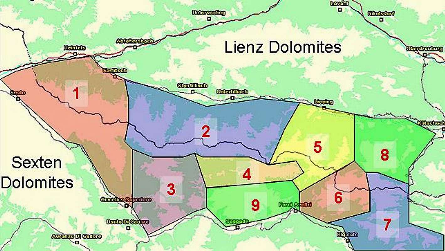
Geographical Classification : Eastern Alps > Carnic Alps > Carnic Alps Main Ridge (West) > Spitzköfele

Spitzköfele photo_id=111500

The Carnic Alps Main Ridge runs from west to east for 130km between the villages of Sexten (Sesto) and Thörl-Maglern. It is a complex ridge, which often winds away from the straight line. The summits on the ridge are very diverse in terms of rock composition, which is due to the geological history, which put the mountain range at the centre of the Alps build-up ages ago.

From this ridge quite a number of side ridges run to the north into the Lesachtal Valley (the valley of the river Gail). The mountains on most of these ridges are rather easy to get to, there are some notable exceptions like Zwölferspitz, which can be climbed only over an UIAA grade II grass climb, dangerous in wet conditions). All of these summits, however, are great lookout peaks - very close to the Carnic Alps Main Ridge with great views of the neighbouring mountains, but at the same time high enough to offer good views of the Sexten and Lienz Dolomites. Speaking of altitudes - though easy to reach, it takes a long day tour to get there and back so you certainly should not underestimate any of them.

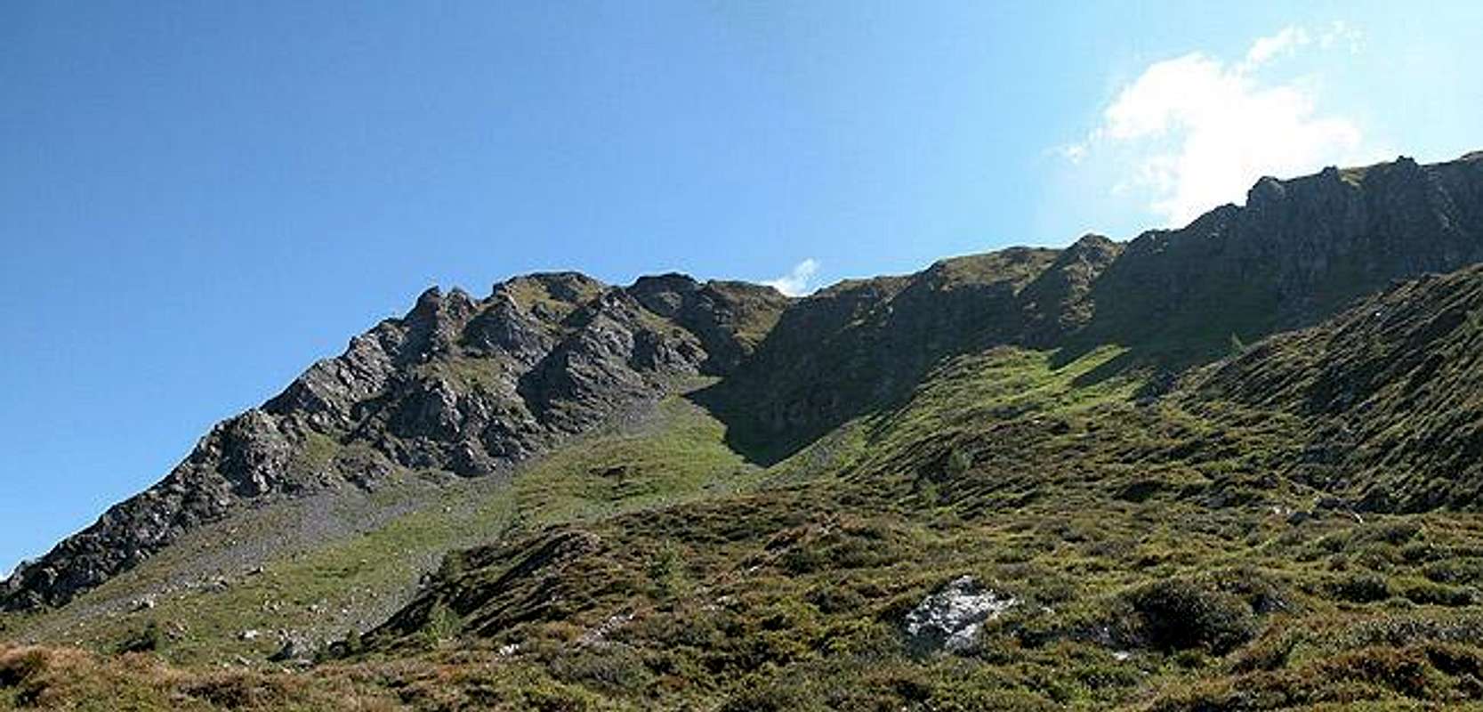
Spitzköfele is a case in point. It is located on the ridge between Obertillacher Tal and Rollertal. There are two beautiful ascent routes through the two valleys, which can be combined to do a loop. Starting point is Obertillach, though you can go deep into Obertillacher Tal by car. This, however, will rob you of the opportunity to do the loop. The mountain is located close to Porze (Cima Palombino) and Crode dei Longerin, two of the best known climbing summits of the Carnic Alps.

Both ascent routes to Spitzköfele touch upon Karnischer Höhenweg, the multi day trekking trail, which runs along the old World War I paths over the whole 130km of the Main Ridge. The final ascent from the trekking trail to the summit is rather steep and in places exposed. The summit cross, like on so many summits in the Alps is placed on a false summit to the north of the real one (in order to be seen from the valley floor). In this case the difference in altitude is minimal, just about 5m.

The Spitzköfele summit itself is composed of black volcanic rock which peeps out of beautiful meadows with lots of flowers. to the eastern side it is rather smooth whereas on the western side it shows vertical drops of up to 150m. Spitzköfele, however, is no climbing summit. The black rock is far too lose and fragile for any serious route.

The 360° Summit Panorama


Decide for yourself, if the summit is worthwhile.....

Spitzköfele photo_id=111527Spitzköfele photo_id=111529Spitzköfele photo_id=111530Spitzköfele photo_id=111531
Spitzköfele photo_id=111532Spitzköfele photo_id=111533Spitzköfele photo_id=111534Spitzköfele photo_id=111535

Getting There


Western Main RidgeWest Central Main RidgeCrode dei LongerinPeralba - Chiadenis - AvanzaEast Central Main RidgeBiegengebirgeKellerwand - Hohe WarteMooskofel GroupRinaldo Group
Interactive map of the western part of the Carnic Alps Main Ridge. The numbers refer to the respective subgroups as given on the Carnic Alps Main Ridge (West) Page. Click on them to go to the subgroup description. Spitzköfele is located left of center in subgroup 2.

The best starting point for an ascent of Spitzköfele the village of Obertillach in the Lesachtal Valley. You can either start in the village or drive by car into Obertillacher Tal, starting the ascent from Hirtenhütte. Lesachtal is rather remote but getting there is far from complicated (though lengthy).

From the West (Brenner Motorway A22)
Leave the Brenner Motorway near Brixen / Bressanone and follow SS49 to the east through Pustertal / Val Pusteria. To the east of Innichen / San Candido you cross the Austro-Italian border and follow the road (now B100) to Tassenbach. Turn right (south-east) here onto B111, which you follow to Obertillach. There is a parking lot near the postal office in the centre of the village

From the North
There are two possible roads:
  • From Kitzbühel over B108 through the Felbertauern Tunnel to Lienz, then southeast to Oberdrauburg and Kötschach-Mauthen (B110), where you turn on to B111 west into Lesachtal.
  • From Salzburg along motorway A10 to Spittal. Turn west on B100 to Oberdrauburg, there south to Kötschach-Mauthen were you turn east on B111.

From the South (Udine)
Take Motorway A23 to the exit Camia Tolmezzo. Follow SS52 north to Tolmezzo where you turn onto SS52 bis. This leads to Plöckenpass, where it crosses the Austro-Italian border. In Austria the road turns into B100 and at Kötschach-Mauthen you have to turn east on B111 into Lesachtal Valley.

Red Tape


Spitzköfele photo_id=111628

I'm not aware of any red tape except for the usual restrictions concerning flora and fauna. Camping is not allowed but you can take rooms in Obertillach or at the New Porze Hut which is located an hour to the southwest of the summit.

When To Climb


Spitzköfele is an all year destination. The summer season runs from June through late September. In winter the summit is quite popular for ski tours (both ascent routes. Keep in mind that the Lesachtal Valley only offers one ski lift, from Obertillach to the north. The Valley is better known for cross country skiing and biathlon. In the summer the lift is used by paragliders and on a fine day you can see dozens in the air above the village.

Accommodation


In most of the villages of the area there is a small campground, which in most cases is associated with an inn or hotel. If you are looking for hotel rooms or apartments follow one of the links below

Weather Conditions


In general the weather in south-eastern Austria is much better than in the northern and western parts of the country. Europe mostly is covered by western winds and the clouds from the Atlantic have to climb over the Alpine Main Ridge before they reach Osttirol or Kärnten. So much of the humidity is left somewhere else… For up to date weather information (city of Lienz, 20km to the north) follow the link below.
For Webcams try the link below:

Maps 'n' Books


Maps
I have been using a map by Kompass Verlag, which is very good for the hiking trails though it does not show ALL the relevant summits of the area.
  • Lienzer Dolomiten / Lesachtal

    1:50000
    Kompass Map WK47
    Kompass Verlag
    ISBN: 3-85491-053-3

As for books please look at the corresponding section of the Carnic Alps page.


Children

Children

Children refers to the set of objects that logically fall under a given object. For example, the Aconcagua mountain page is a child of the 'Aconcagua Group' and the 'Seven Summits.' The Aconcagua mountain itself has many routes, photos, and trip reports as children.