
-
 2668 Hits
-
 74.01% Score
-
 4 Votes
|
|
Route |
|---|---|
|
|
46.65456°N / 13.41092°E |
|
|
Hiking, Scrambling |
|
|
Spring, Summer, Fall |
|
|
Most of a day |
|
|
Medium hard hike |
|
|
Rating the Route (By Hiking Standards)

On Radniger Alm
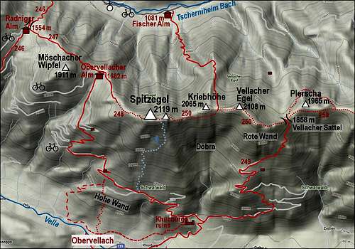
0. General: From 996 m to 2119 m, exposition N, W and S. At first a mountain road to Bodenalm and another one to below Radnig Alm. Then a cart road and a broad path to Radnig Alm, then a comfortable path to Obervellacher Alm and further to the summit ridge. Finally a steep rocky section which requires some easy climbing of UIAA degree I, and then the rocky, easy summit ridge. Gear: Good hiking shoes and poles. The upper part is very panoramic.
1. Effort: cca 1200 m, 4 h (the tour goes much around).
2. Power: 3 - Moderate (mostly 1, only walk up, below the summit some easy climbing).
3. Psyche: 3 - Moderate.
4. Orientation: 2 - Easy (all the time marked).
Getting There
See the main page of Spitzegel, how to get into the valley of Tscherniheimer Bach! The parking place is in Weissenbach, the road further up the valley is closed for public traffic.Route Description
From the parking place we continue by the road. Till Bodenalm, 1231 m, we have some 40 minutes of walk. On the meadow before the hut another mountain road deters left and goes in several turns southwards up the slope. The marked path No. 246 keeps to it, doing a few shortcuts. Some 150 m below the saddle in the main ridge the road turns into a very steep and rugged cart-road, soon later into a broad path. Due to steepness and rough gravel one or two sections are not appropriate even for a mountain bike, but having a bold plan (for example to bike on Obervellacher Alm) you can decide to do a bike-and-hike tour as well. Just beyond the saddle, 1554 m, lies Radnig Alm, where a mountain road from Gail/Zilja valley reaches.From Radnig Alm the road continues over the southern slopes of Moeschacher Wipfel up to Obervellacher Alm. That's quite around, so if we are on foot, we just follow the well marked path No. 247, which crosses the N slopes of that hill, going in a SE direction. After the crossing, we find ourselves on the grassy slopes of Obervellacher Alm - the Laudinzenhuette (hut), 1682 m, is a little below the main ridge. The marked path now turns into No. 248. It goes over the meadows just below the main ridge then starting to cross the slopes, covered with larches and pine bushes. The path is broad and comfortable, until it reaches the summit tower of Spitzegel. There the path goes by a shallow, steep ravine. First we cross to its right edge (looking up), then we start climbing up and slighly towards the left. The route is well marked, but nowhere secured, so easy climbing of UIAA I degree is needed. Higher we go straight up the ravine, then the route climbs over some more rocks to the right where it gains the main ridge which brings us on top.
We can descend by the same route, but a bit quicker and more beautiful is to continue eastwards, so doing a nice round tour. See the route description: Spitzegel From Fischer Alm (in a reverse direction).