
-
 6143 Hits
-
 74.01% Score
-
 4 Votes
|
|
Route |
|---|---|
|
|
39.19360°N / 106.112°W |
|
|
Hiking |
|
|
Spring, Summer, Fall, Winter |
|
|
Most of a day |
|
|
Class 1 walk-up, some route-finding |
|
|
Overview

Horseshoe Mountain from just below the summit of Sheep Mountain F
7 June 2008
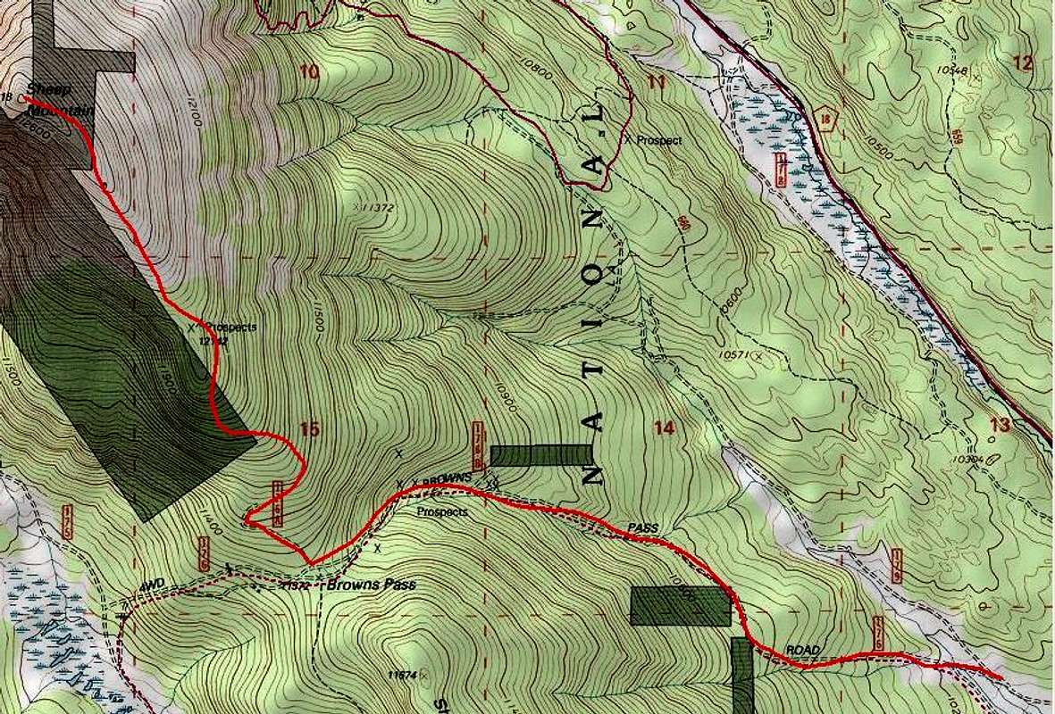
Elevation Gain: 2,590 ft.
USGS Quad: Fairplay West
Trail Illustrated Map: #110 Leadville Fairplay
This Class 1 hike on mostly solid footing requires little more than stamina and perseverance combined with basic navigation skills. Navigation is required for a short wooded section where the trail peters out between what is posted on-scene as Forest Service jeep road 176A and what is identified on maps as Forest Service motorized route 691.
Note that while the forest service has designated 691 as a motorized route, only a skilled dirt biker with plenty of patience and a willingness to travel slowly could/would travel the higher altitude reaches of this route in a motorized fashion. During an early June visit the only signs of humanity we witnessed between Browns Pass and the summit of Sheep Mountain F were ski and snowshoe prints.
This is a primarily south-facing route on a 12er sitting somewhat in the snow shadow of the peaks to the immediate west. As a result, this hike is a good early shoulder-season option when routes up other peaks are blocked by soft snow.
This route features a hike through a ghost tree and krumholtz forest and, once above timber-line, wide-open views as far as the eye can see for a solid mile or more of the hike.
Getting There
- From Fairplay, follow Hwy 285 south for approximately 6 miles.
- Turn right on County Road 658. (This road may not be marked as CR 658. The turnoff is about 4 miles south of Fourmile Road and two miles north of Weston Pass Road. If, after turning off Hwy 285, you see a Forest Service sign for Brown’s Pass, you are in the right place.)
- Set your odometer back to zero.
- At approximately mile 3 veer right on FS 176. (Shortly after turning onto FS176, if you stay right, you’re on 179. Go left to stay on 176.)
- Follow the signs to Browns Pass. At approximately mile 5, you will reach the Forest Service gate. (2x4 vehicles park here.)
- Shortly after the gate you will encounter a water crossing that is likely to be shallow by quite wide. Use solid judgment in determining whether to take the water crossing on foot or by vehicle.
- Standard 4x4s: Go as far as comfortable (that is, proceed as far as the capabilities of the vehicle and driver allow); find parking. Note that once the road begins steep uphill climb to the west at about 10,900 feet the road becomes considerably steeper and rougher and parking becomes very limited.
- Customized or small-wheelbase (e.g. Jeep) 4x4s with powerful 4-low or ATVs: Park at Brown’s Pass summit.

Looking westward from the southeast ridge of Sheep Mountain F
7 June 2008

Looking south-southeast down the summit ridge
7 June 2008
Route Description
- From the summit of Brown’s Pass head due-north on a wide ATV trail marked as 176A.
- Quick eyes may pick up a faint trail and tiny cairns to their right, but many hikers will continue on 176A until it peters out at an ATV turnaround.
- Continue to navigate through timber, heading north or north-northwest, until coming upon trail 691 (unmarked). Member update: There is now a plexiglass sign and steel entryway of sorts indicating the beginning of trail 691.
- Note that the trail may appear to be “on again, off again”, at least with deep snow drifts present.
- As the trees thin, ahead of you will be a bulky plateau with a false summit peering out behind it. Skirt this plateau to the east.
- Around 12,100 ft. the last stand of trees gives way to bare rock and the climb begins in earnest.
- Follow the primary trail to approximately 12,500, then depart trail 691 to strike out northwesterly across the rocks and tundra of the broad summit ridge.
- A final push to the west brings you to the 12,818 ft. summit of Sheep Mountain F.
Essential Gear

Looking through a ghost forest toward Sheep Ridge
7 June 2008
- Long pants to protect tender legs during the brief bushwhack.
- Topographic map
- Compass
- GPS
- Colorado Atlas and Gazetteer (for back road navigation)
- Trekking pole(s)
- Sturdy hiking boots with grippy soles and stiff ankle support
- More water than you think you will need (limited water is available on the lower reaches of this route)
- First aid kit
- Other standard backcountry essentials
External Links
Pike & San Isabel National ForestsPike National Forest Recreation Map