
-
 42943 Hits
-
 81.84% Score
-
 15 Votes
|
|
Route |
|---|---|
|
|
47.47400°N / 120.945°W |
|
|
Hiking, Mountaineering, Trad Climbing, Scrambling |
|
|
Spring, Summer, Fall |
|
|
Most of a day |
|
|
5.4 (YDS) |
|
|
3 |
|
|
II |
|
|
Approach
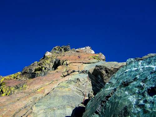
The route approach to this fun technical rock route is on the main page. This route is popular and can be crowded. Get to the climb early or try mid-week to avoid these crowds. Follow the trail to Ingalls Lake from the Teanaway Trailhead and pick the best route up the class 2 and 3 slabs and talus to the left. Look for the cleft between Ingalls North and South Peaks which marks the beginning of the South Ridge Climbs. Make a few class 4 moves up the gully to a ledge which begins the class 5 climbing
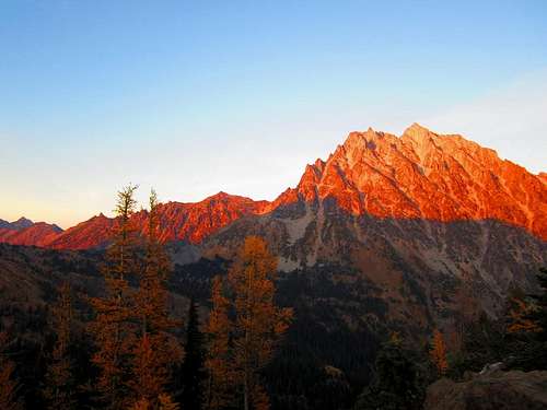 Sunset on Mount Stuart from Ingalls Pass Sunset on Mount Stuart from Ingalls Pass |
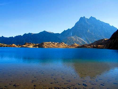 The classic reflection photo from Ingalls Lake The classic reflection photo from Ingalls Lake |
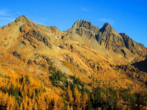 View of Ingalls Peaks from Ingalls Pass View of Ingalls Peaks from Ingalls Pass |
Route Description
| Pitch | Photo | YDS/Length | Description |
| 1 |
 Pitch 1 Pitch 1 |
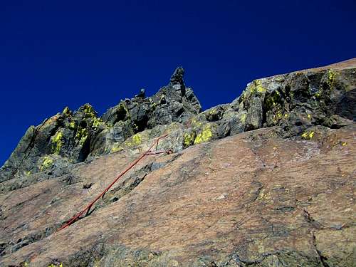
5.2/80 feet | The route resembles more of a face than a ridge from this perspective at the base of the route but rest assured, there are good cracks for protection. The first pitch consist of a low class 5 scramble up the obvious large crack in the middle of the slab. Climb this to the first ledge and then on to a second large ledge for a total of about 80 feet, and anchor into a huge rock with numerous slings wrapped around it. In the photo to the left, you will notice I am leading a slabby thin set of cracks to the left of the large correct crack. Do not do this unless you're looking to make the first pitch harder (and more fun)! The route I took closer to the huge open book is more like 5.7. Be very careful on the second ledge as there are several very large and loose boulders waiting to fall out onto the approach route. It may also be good to note the large crack on this first pitch has been rubbed smooth due to the many people that have climbed it and the rock pretty slick. If you solo this pitch just note that you may have less grip than you think. |
| 2 |
 Pitch 2 Pitch 2 |
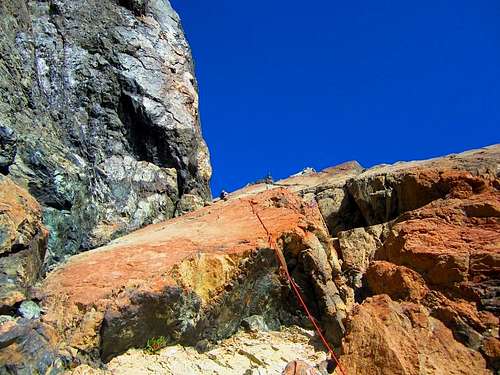
5.4/115 feet | The second pitch has several variations. The easiest and most popular is the crack on the far left which consist of well protected 5.4 climbing. The middle crack, which I highly recommend, is around 5.6 according to the Fred Beckey or Jeff Smoot guides, good protection and very clean. Just before you reach another large ledge above the second pitch, there is a small stance with room for a few people at a bolted belay anchor with chains. Belay here as there isn't really any good spots to make a trad anchor on the ledge just above. The photo to the left shows the second pitch from the large ledge at the base of the second pitch. |
| 3 |
 Pitch 3 Pitch 3 |
5.4/80 feet | From the bolted belay ledge, climb straight up over a 5.4 move to reach the big ledge above. From this ledge, the smooth face to the right looks hellish. This is not the route. Veer slightly leftward and aim for the right facing open book and climb the positive angle dihedral. Stay just to the right of the small tower you see from the top of the second pitch which comprises the left side of the open book. You essentially follow the easiest path up...you can't miss it! This section may be considered 4th class by some. You will top out abruptly on easy terrain and the true summit is a short scramble to the north towards Mount Stuart. There is a chalkstone with lots of slings to use as an anchor at the top of the pitch where the terrain eases. There is also a few bolts here but I guess I didn't notice them. The final slab that marks the summit is a fun friction scramble (Class 3) to a tiny summit. The photo to the left shows the third pitch from the bolted belay anchor at its base. Climb up to the obvious gap just right of the tower. |
Descent
The loose west face can be down climbed to a point where you can traverse back to the east and the beginning of the South Ridge climb. I recommend that one rappel the climbing route back to the beginning of the climb, despite what is said in the Beckey guide. The rappel can be done in three raps with a single 60M rope.
Rappel 1: From the end of technical climbing, rappel to the bolted belay ledge atop pitch 2
Rappel 2: Rappel from the chains down the face veering to skiers left. A 60 meter rope will just barely get you to Class 3 rock where you can then scramble down to the next ledge with the large boulder atop the first pitch wrapped in many pieces of webbing.
Rappel 3: Rappel from the large boulder to the talus below.
Essential Gear
Small rack to 2" and stoppers worked great. Slings are recommended as the route tends to zigzag. A 60M rope is required. Bring webbing as the rap anchors may need replacing at times.
A note about the rock - The rock type here is serpentine which is a result of contact metamorphism when the Mount Stuart batholith (granite) intruded through a suite of mafic volcanic rocks. The orange coloring of many of the peaks surrounding the crest of the Stuart Range is a result of weathering of the serpentine rock which is not stable at the surface. Without going into a large scale geology lesson (which I can do), I will finish my statement by stating this rock is slick!!! Climb with extra care.
 A climber on Pitch 2 A climber on Pitch 2 |
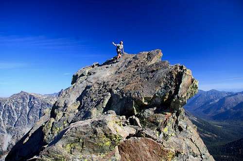 On the summit of North Ingalls Peak On the summit of North Ingalls Peak |
Map
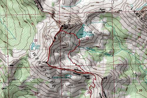 Route Map...the approach is the red line to the eastwhich passes by Lake Ingalls. The return route to the west is an option which allows you to add South Ingalls and Fortune Peak on your way back (Class 3). This brings you right back to Ingalls Pass.
External Links
Another great TR from Cascade Climbers
smcintyre - Jul 27, 2023 5:51 pm - Hasn't voted
Don't go up between the North Peak and East PeakJust a small addition about where to go in the gulley to find the start of the climb. The instructions on this page say to go up to the "cleft" between Ingalls North and Ingalls South, which is correct. I might call it a col more than a cleft, but in any case, you go straight up the gulley until you're within, ~20 vertical feet from the ridge then turn to your right to start the climb. My party got a little turned around because the cleft between Ingalls North and Ingalls East is, well, more cleft-like. Don't go that way; follow the instructions as written and don't overthink it.