
-
 10465 Hits
-
 79.04% Score
-
 10 Votes
|
|
Route |
|---|---|
|
|
46.41074°N / 13.72501°E |
|
|
Hiking |
|
|
Spring, Summer, Fall |
|
|
Half a day |
|
|
Easy |
|
|
Overview

The upper valley of Soča
Sometimes the most beautiful hikes are not just high on the mountains. But what can be the reason to hike by the valley bottom, instead above, over the panoramic slopes and summits? It's the river. Soča, the most beautiful river of Europe.
When driving through Trenta, the upper part of Soča valley, people can stop their car and visit a few most beautiful parts, such as gorges by the village of Soča or Mlinarica gorges. But it is an entirely different story if you walk along the whole upper part of the river, making a distance of some 20 km (or at least the upper 16). For foreigners, whose time of staying in Slovenia is limited, that may of course not be the first priority. Go on the beautiful high mountains around first! But you may have a day in your holidays, which is not most appropriate for high mountains. Or you may simply want a day of relax or may be you have small children with you whom you also want to offer a nice hike. And, in hot summer days, the Soča hike can even be the best option of all.
We can start the tour in Bovec, 450 m, but it is better to leave car in the mouth of Lepena valley, on the camping parking place. An even better idea is to first drive up to the very source of Soča leave there bikes and only then drive down to the chosen trailhead. On the whole tour you will do the distance of 20 km and the altitude difference from 450 m (Bovec) to 1000 m (the source of Soča).
Getting There

Near Klinar camp

Take a bath?
See the parent pages of Soca canyon and Julian Alps to see how to get into the valley. The trailheads are:
> Bovec or the confluence of Lepenjica and Soča, or
> The hut at Soča source.
Route Description
View Larger Map
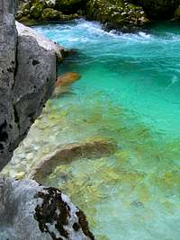
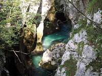
From the camping place Klinar you start walking upsteram by the southern bank of Soča. There is immediately the first big attraction - Velika korita Soče (big gorges of Soča). Go on many places from the marked path just to the edge above river and look down into the some 20 m deep and very narrow, most picturesque gorge.
 Velika korita Soče |
 Velika korita Soče |
After the gorge ends, you soon reach oposite to Soča village. If you have time it is worth exploring it a bit. The trail continues along the southern bank and soon you reach the confluence of Vrsnik creek. You pass a few nice farms and another camp, then you continue by the same side of the river towards the NE.
 A typical Trenta farm |
 Mala korita Soče in autumn |
 Mala korita Soče |
The scenery is always nice - a vivid river with many fine ponds, nice meadows and solitude farms in a respectful distance from the river and its torrental nature. Then the path hits a place where two major landslides happened years ago. The endangered farm was abandoned, others still persist. For a short section the path goes on the other side of the river, then soon returns back and continues towards Na Logu (Trenta) village.
 The stream of Soča |
 By the river |
 The trail below Na Logu |
Just before reaching the camping place before that village, the path crosses the river again (backwards by the bridge) and on the other side resumes the NE direction. Before reaching opposite of Na Logu village, the path starts ascending more steeply left up the hill, thus cutting the sharp knee of Soča river. We gain some 150 m of altitude and on the other side soon lose it. There the path continues along the river, now in the NW direction.
Soon we find ourselves opposite to the cute church of Virgin Mary and continue a bit more northwards. On the place where the main road crosses the river, our trail hits it and continues by it, but only till the path branches right to visit the famous Mlinarica gorge. That wild place is certainly worth a visit - in some 20 minutes the path brings us just into the gorge mouth and above the entry waterfall. After viewing Mlinarica, we return back and continue by the Soča trail up the hill to the monument to the poet of Julian Alps - dr. Julius Kugy.
From the monument we descend down by the road, but only to the first left curve where the mountain road deters from the main road - the directuion is Koča pri izviru Soče (The hut by Soča source). There hopefully bikes are awaiting us, but if we hadn't done that before, we should visit also the very source of Soča. In less than 15 minutes the marked path brings us into a shady corner, where from the slopes of Dnina the emerald river sources. Then only we return to our bikes and ride down to the starting place.
 Below the source of Soča |
 To the source of Soča |
Returning back by the road, we can also visit other interesting places, like: Alpinum Juliana (the alpine garden is especially nice in June) or the Triglav National Parc Center in Na Logu village.
Essential Gear
Good shoes, poles.