
|
|
Route |
|---|---|
|
|
48.04150°N / 121.3401°W |
|
|
Mountaineering |
|
|
Summer |
|
|
One to two days |
|
|
5.4 (YDS) |
|
|
Overview
Although this is often mentioned as a descent route, and indeed described “coming down” on the west face route page, I think as a climb “up” it deserves a page with the description written from perspective of ascending, so here it is.
The SE face of Sloan is an quieter alternative start to the well-traveled corkscrew route, avoiding travel on the more heavily crevassed north side glacier, and replacing that with other obstacles such as higher class rock climbing (but only in small doses), and variable access issues to the big ramp, depending on how late in the summer you go, as the small glacier at the base recedes quickly during the melt (more on this in the climb section). The route eventually merges with the corkscrew route. As a route up, this is probably rarely done, but it has its own charms depending on your criteria for enjoyable climbing.
Getting There
Find forest service road 4096. This is located about 5 and ½ miles north of Barlow Pass, which is east of Granite Falls. Alternatively, one can access the area by driving south from Darrington on the mountain loop “highway”… highway in quotes here because it is a gravel road between Darrington and Barlow Pass, and you won’t be going at highway speeds. Road 4096 is a little over 1 mile south of Bedal campground and/or the North Fork Sauk River road junction coming from that direction. Road 4096 is the east side of the “highway”, and as of summer 2013 has a discreet little “4096” sign on a post, which is the only clue that this rough looking track is the right place. Drive uphill for about 2+ miles until a berm cut across the road stops you. Park in the wide spot and find the trail right there on the uphill side, by the post that used to hold the Bedal Basin trail sign.
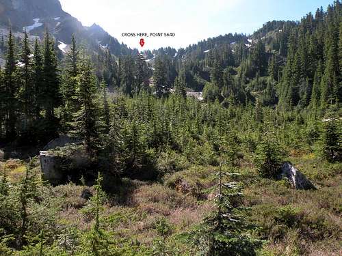
Aim for the marked spot in the distance. It gets steeper at the end, but you will find boot-built steps in the steep grass and heather.
Hike the Bedal Basin trail, initially in good shape through nice forest for almost 2 miles, then suddenly this forest is gone at a large bouldery washout. Step into the washout, head uphill following rock cairns, trending mostly along the right side. A couple hundred yards uphill on the north (right) side of the washout you can see mature forest on the north bank; that is where you will find the trail climbing up out of the washout. This again provides good travel for a few hundred yards up into the opening flat of Bedal Basin where the trail ends. The west face of Sloan Peak towers above. Continue cross-country southbound through invitingly open sub-alpine terrain. You are aiming for the ridge coming off Sloan’s west face, to cross at about 5640+ (see photo). You will find occasional boot track in the steeper sections. At the ridgetop follow the climber’s trail to the left through a momentarily thick band of forest, then out into the wide open basin. Traverse uphill to one of the most spectacular camps anywhere in the area, complete with a large rock wall, on point 6619. Takes about 4 hours or less. From here, you have a great view of the SE basin. Water is not available right at the perch, but can be found by scrambling down to the base of the SE basin glacier a couple hundred feet, so if camping here, might want to bring a water bag or something for carting water up to camp.
Route Description
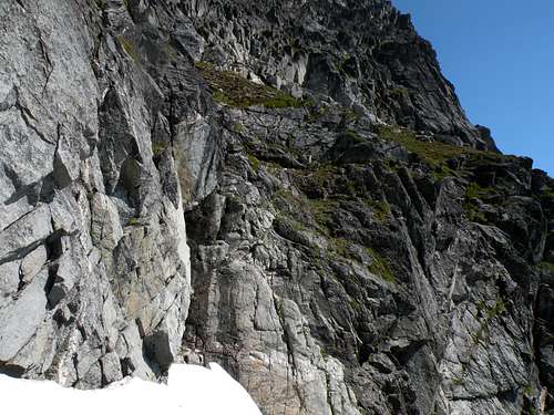
The SE basin of this mountain is quite a dramatic amphitheatre with very vertical rock looming above. The glacier is often littered with rock, so travel here without a helmet is a tad risky (Last time I was here, I was indeed beaned by a fist sized rock; a helmet made it just a startling surprise with no injury, without one I’m certain I would have been injured).The big obvious ramp slicing across the otherwise vertical face is the way up, you’ll see it descends into the glacier all the way across the basin from camp.
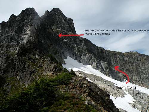
The lower arrow points to the obvious shelf entrance. The arm of the small glacier recedes as summer progresses, exposing increasingly difficult rock. Up higher, the "alcove" step up to the corkscrew route grass shelf is hidden just out of view from here.
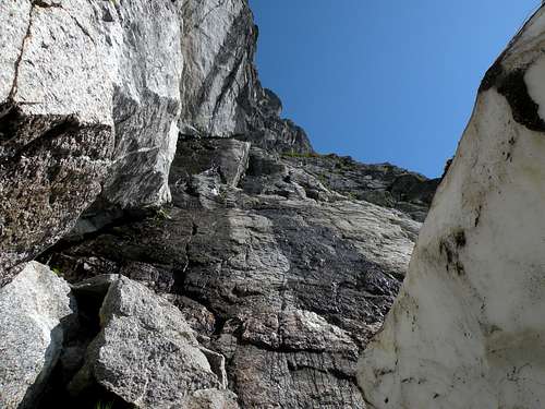
How late in the summer you go on this route is a big factor. Earlier in the season the small glacier occupying the SE basin has an arm that leads onto the ramp higher up, providing passage over some steeper rock. By August this arm begins to recede exposing steeper polished slabs that are low class 5, complete with water trickling over it in spots. Either way, once onto the slightly lower angle slab climbing mid-way up on this ramp, some caution is still required, as evidenced by scattered bits of webbing from rappels. Earlier season will find large chunks of ice laying on these lower angle mid-way slabs, but normally these are easily bypassed. There is just something about the rock on the first couple hundred feet of this tilted shelf, it is sometimes clean and smooth, sometimes grit covered, sometimes slime covered from the trickling water, that makes one consider roping, especially descending, just to be able to relax on this terrain that seems like it should be easier. Problem is, there are few spots to make truly secure anchors; most of the slings do not look very reliable, looped over marginal projections or around boulders that also seem perched, waiting for a good pull to send them sliding down the smooth rock. Higher up on the ramp, grass and boulders make for a greater feeling of security, as though hiking a narrow tilted alpine meadow, footing becomes more secure.
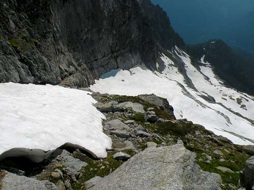
Looking back down the SE shelf from the tilted "meadow". This is earlier summer when large ice blocks still exist in spots.
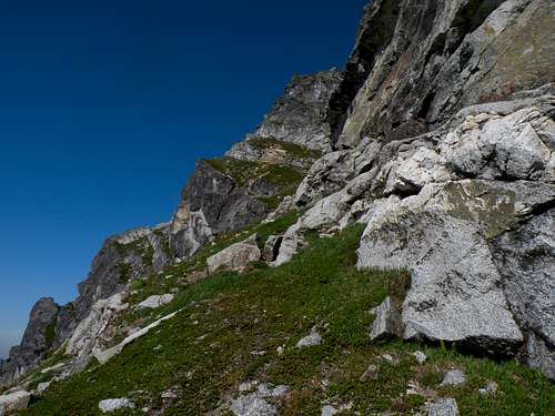
This is higher up on the shelf "meadow", just as the rock wall begins to curve inward toward the key alcove.
Once on this “meadow”, hug the uphill rock wall and ascend; the wall curves into an obvious alcove. Earlier season this alcove will be occupied with a chunk of ice but you can walk behind it, later this melts away. At the back of this alcove is a vertical step, this is key to the route.
Earlier season in this view, ice occupies the foreground, but there is room to scramble behind. The vertical wall behind with the water stains is the mid class 5 step.
Looking straight up the alcove step from behind the ice.
A couple of challenging moves, probably mid-class 5, gets on to easier ground, the angle eases into class 3 and big foot-sized steps present themselves. Continue up the obvious ravine, increasingly grass covered, and intersect with the “corkscrew” climbers trail. You can’t miss this well defined trail, almost looks like your standard park service maintained hiking trail, except for the next-to-vertical-drops it will take you past. Follow it first southwest to a sharp corner on the south ridge, then northwest, perched airily above big drops over the west face. Eventually the trail turns upwards into a shallow depression and then a ravine to the ridgetop. A short and fun scramble along the top leads to the summit.
As described on the west face page, descending this route requires finding the same ravine back down to the class 5 step to the lower shelf, be sure to note where this is so you will recognize the spot on your return. In this ravine, there are already a number of well-secured slings in place making rappels or rope protected down-climbing much safer.
Essential Gear
Ice axe, crampons, helmet, short rope, a few webbing slings, perhaps a knifeblade piton or two (for the slab sections).Red Tape
This area lies within the Henry M Jackson wilderness, so regulations apply. Forest Service website: http://www.fs.usda.gov/detail/mbs/specialplaces/?cid=stelprdb5189218
Both the trailhead parking permit and wilderness travel permit are probably required, but the rough nature of the trailhead road and lack of signage makes me wonder if there is any enforcement. Most trailheads where enforcement takes place now have signage indicating the requirement for the parking pass. Plus the forest service website says the free wilderness permit can be obtained at trailheads; well, this trailhead has nothing of the sort, so if one was to run into a ranger in the backcountry (which I think is unlikely here) I doubt much would occur in the way of enforcement action.