
|
|
Route |
|---|---|
|
|
18.98456°N / 97.35143°W |
|
|
Hiking |
|
|
Half a day |
|
|
hike, easy scramble |
|
|
Overview
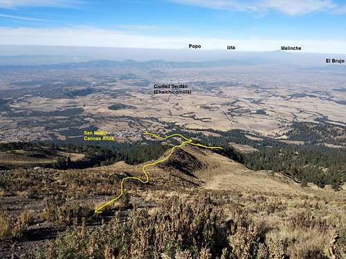
Sierra Negra volcano (4580 m a.s.l.) is most commonly ascended from Valle del Encuentro, the 4000 m high saddle that separates the mountain from the much higher Pico de Orizaba. If you are looking for longer hikes, this is a good option (6 km, ~4 hours one way). It starts at the village of San Isidro Canoas Altas, allowing an elevation gain of over 1500 m. This trail will lead you through fir and pine forests, through alpine grasslands and scree deposits, all the way to the Large Millimeter Telescope (LMT).
Getting There
The trail starts at San Isidro Canoas Altas. The best way to reach the village is, of course, by car. As far as I know, there is also public transportation from the mountaineering hub town of Ciudad Serdán. If I find out one day, or if you have relevant information about this or other things, please write a comment below and I will gladly include it. :-)
Inside Canoas Altas, go to the northeastern village limit. The paver ends at the location marked in the route description above. With an appropriate vehicle, you could continue on this road, but I would advise against it (see the mountain's main page for more details). If you arrive by car, pay attention that you do not block any accesses or wide turns. Also, leave a visible note inside the car ("Subimos al monte" = "Went hiking", stating date and time), or notify the neighbors, as people in rural Mexico tend to be suspicious of strangers.
Route Description
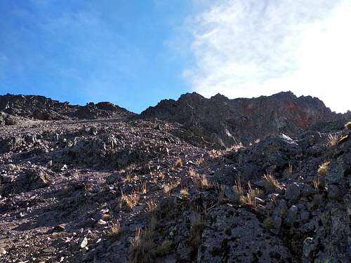
 The trail as seen from the upper parts
The first 400-or-so meters are on this road that leads up to Valle del Encuentro. If you do not feel particularly adventurous, continue on this road. If you do, take a right turn away from the road and into some fields. Continue on a windbreak between the fields and then turn left and cross the field where the trees end, after approx. 1.2 km total. Here, you will find a pretty clear trail leading uphill, into the dense fir forest.
The forest gets noticeably thinner at an altitude of around 3600 m. As the tall grasses begin to cover the ground, the trail disappears. But fear not, the grasses are relatively easy to traverse. Continue uphill and find the ridgeline between the gullies. As you gain altitude, the ridgeline gets rockier and less grassy. Soon you will have a glimpse of the telescope on the summit. From here, follow your instinct. Although no formal trail is visible, you will have a clear view of the upper parts, allowing you to decide your route well in advance.
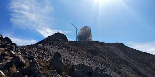
 Scree deposit at around 4200 m a.s.l.
The most strenous part begins at around 4100 m. It consists of unconsolidated sand and rocks, so you will have a taste of "two steps forward, one step back". For your own safety, stay close to the bigger rocks, and calculate their stability before applying your full weight on them. The altitude, combined with the sun you've had shining in your face all morning, will mess with your senses. Focus. Drink some water. Rest a bit. Plan every step. Use your hands.
 Almost there!
You will approach the summit from "behind", so you have to go around the fenced LMT area clockwise. If you are lucky, you will find the gate open in order to sneak in to the summit, which is located next to the LMT. Just don't do anything stupid, and you will be tolerated. If you are interested in the facilities, you have to announce your visit a few weeks in advance. Go to the INAOE website for more information.
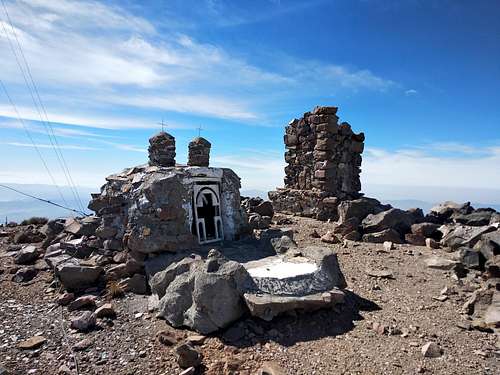 Summit (4580 m a.s.l.)
I suggest you not to take the same route down, as the loose upper parts can get tricky. Better descend into the Valle del Encuentro and take the road down. This also allows for some phantastic views of Pico de Orizaba. If you don't have a car, it'd be better to head the other way, down to Texmalaquilla and Atzitzintla, where transportation is better.
Essential Gear
No special equipment is required, unless it has snowed recently. Bring high-cut hiking boots, a wind jacket, along with sufficient snacks (apples, nuts, raisins, cookies and a sandwich) and water (2 l), as well as sunscreen and sunglasses.