
-
 15123 Hits
-
 79.78% Score
-
 11 Votes
|
|
Route |
|---|---|
|
|
50.91314°N / 14.20531°E |
|
|
Hiking, Via Ferrata |
|
|
Spring, Summer, Fall |
|
|
Half a day |
|
|
Medium hard hike |
|
|
Overview

Schrammsteine sports

The scene

Water source
Saechsische Schweiz is a wonderful landscape of rock towers, rising out of nice woods. The area is protected as a natural parc, and offers great possibilities of climbing (European free climbing was born there), hiking and other outdoor activities. Trails are well marked, you can buy good maps and plan tours by your own instinct. However some parts are so beautiful, that they are worth to be prioritised. The ridge of Schrammsteine is such an area.
If you buy a hiking map of the area (1:10000), you are safe to find the way. We had none, and were also late in the afternoon, so a few tense moments arised in the eastern part of the area, where we had to find the path down towards our trailhead. A photo camera shot of a rough map from the table was of a poor assistance.
See more of an overview on the main page of Saechsische Schweiz.
Rating the Route (By Hiking Standards)
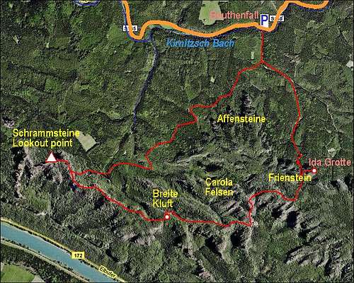
A self-made map of the area
The grading system for hiking and scrambling routes is here.
0. General: The round tour is mostly easy, by good paths, well secured and marked. A few passages however on the proposed round itinerary are steep and exposed, the entry to Ida Grotte very exposed. You need no special equpment, only hiking shoes.
1. Effort: cca 400m of altitude altogether, with ups and downs, 4h for the whole round tour.
2. Power: 2 - Easy (mostly 1 - no difficulties, on some places a few pull-ups).
3. Psyche: 2 - Easy (only the entry in Ida Grotte requires that the hiker is free of vertigo).
4. Orientation: 2 - Easy (all the time marked). Some care due to many paths and options.
Getting There
The ridge of Schrammsteine rises between the Elbe river (on the S-SW) and the valley of Kirnitzsch creek (on the N). So, it can be reached by both sides, and, in addition, also from the west, from the village of Ostrau. Some hikers reach the area also when on a long-distance hikes, so possibly also from the east. Due to the abundancy of marked and unmarked trails many hike combinations are possible, each of them incorporating different natural beauties of the area. The ascent routes on panoramic points would take you from 2 to 4 hours, but it is best to plan a round tour.
Here a round tour, starting by Bauthenfall in Kirnitzsch Bach valley is described. The highlights of this tour are:
- Nice view on Affensteine,
- great panorama from Schrammstein lookout point,
- beautiful, well secured ridge route, with nice scenes and views,
- Dreamy nice places on the edge of Breite Kluft,
- The visit of Frienstein area with Ida Grotte (cave).
To get into Kirnitzsch Bach valley, you turn in Bad Schandau, the tourist centre on the Elbe river banks, towards the east. By a good road you drive some 7-8 km. At Bauthenfall there is a parking place, but payable (2009). You can drive a few hundred meters more towards Lichtenhainer Muehle, where parking is free.
Another option, very suitable for hikers, is to use a tourist train, which drives from Bad Schandau into Kirnitzsch Bach valley. It stops on all major trailheads, so you can plan nice round tours.
Route Description
From Bauthenfall we cross the creek towards the south and follow the inscriptions towards Schrammstein lookout point. At first we go by a mountain road, then towards the SW by a good, broad marked path. That is also a mountain bike route. The path goes through nice woods, on one point, if we turn back, we have an astonishing view on the group of Affensteine.
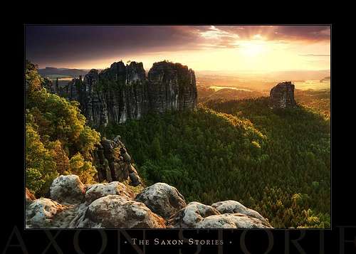
The path crosses a few ridges and does so severel times some 20 meters up an down. We also do quite some distance. Of a total 1h 45min (the inscription in Bauthenfall, we use almost 1h 30min for the woods, the last part is a steep ascent on the summit ridge. It is however well protected (steps, iron fence, ladders) and without problems we reach the ridge and then by it towards the west in some 10 minutes the highest point of the marked trail - the famous Schrammsteine lookout point.
 Schrammsteine view |
 Schrammsteine and Falkenstein |
 Schrammsteine |
The continuation of the route goes towards the south-east, then towards the east. We first return to the point, where we reached the main ridge, and from there continue towards the east. This part of the route is a bit more difficult. Still very well protected, but on a few places also a bit exposed marked path leads us through the most beautiful corners of the Schrammstein ridge. By the southern, northern side and also by the ridge itself we continue towards the east. On a few points, paths deter left and right, but we keep to the ridge (blue marks). So we reach a beautiful panoramic point above Breite Kluft. Picturesque sandstones, birch trees and nice panorama are the three things most valuable to mention.
 Above Breite Kluft |
 Birch trees edge |
 Rock formations |
From above Breite Kluft we continue by the blue path. Towards the left through two valleys paths would bring us down to the ascent route, but it is very recommendable to continue. There are more scenic points on the edge, then the path turns a bit towards the north, towards Carola Felsen. Over these wild rock formations also a demanding protected route goes, but we rather continue right (towards the distand Grosser Winterberg). Through a rock labyrinth we go eastwards until an inscription directs us left towards Frienstein.
 Panoramic scene |
 Pine tree |
Now we descend a bit towards the north, find ourselves by a nice water source where the normal descent goes left down towards the valley. But before the descent is it very worth seeing also the interesting Ida Grotte (cave). So we go right, in a few minutes the path ascends below high rock towers and go through a beautiful birch landscape below them. Tight below the rocks we find a passage through a rock window and on the other side continue by an exposed ledge. There are safe steel holds in the rock however, so the passage is fine, only vertigo would prohibit one to continue. On the other side there is a big cave, from all sides protected by vertical walls. A really interesting place!
 Towards Ida Grotte |
 Towards Ida Grotte |
 Ida Grotte ledge |
Time to descend now. We return to the water source and continue from there by the main path towards the valley. It first descends steeply, so we lose the altitude, the final part then again goes through the woods and by a forrest road to Bauthenfall.
Additional Information Needed
If you have more information about distinct points of interest, please add!
 ond - Schramsteine
yatsek - Aug 17, 2023 5:38 am - Voted 10/10
Changes“… we go eastwards until an inscription directs us left towards Frienstein. This crossroad is easy to miss and if you are tight with time you need to take some care.” Now there is such a massive signpost there that you just can’t miss it.
Vid Pogachnik - Aug 17, 2023 8:47 am - Hasn't voted
Re: ChangesHi Jacek! Thank you very much for your correction!. I deleted the unnecessary sentence. All the best, Vid
yatsek - Aug 17, 2023 2:33 pm - Voted 10/10
Re: ChangesNot at all, Vid. In fact I owe you a debt of thanks for this page, which inspired me to visit Idagrotte. Cheers, Jacek
Vid Pogachnik - Aug 18, 2023 2:45 am - Hasn't voted
Re: ChangesOh, I'm happy to hear that! I was not sure about the correctness of description when posting, because we had no good map and almost no description and then with time I also forgot where we were hiking. Good that you survived :) Cheers!