
|
|
Route |
|---|---|
|
|
46.51696°N / 11.71118°E |
|
|
Scrambling |
|
|
Summer |
|
|
Most of a day |
|
|
EE |
|
|
Overview
Sassopiatto Normal route
Sassopiatto 2958 m (Saspiat in Ladin, Plattkofel in German) is a mountain belonging to the Sassolungo group, that is located between Val di Fassa and Val Gardena. It's one of the few mountains of the Dolomites to show an easy side, which therefore can be climbed also by good hikers.
The mountain owes its name - meaning flat stone - just to its weak side facing South-West, a gentle angled slope. On the contrary the other sides are rocky and steep, as usual for the peaks of the Dolomites. Along this side it runs the Normal route, allowing also the well experienced hikers to reach this summit.
 piercing through the clouds")
Getting There
The starting point of the route is Rifugio Passo Sella, a few meters below Passo Sella m 2240 on the Val Gardena side, which can be reached either from Canazei either by Selva di Val Gardena.
Road access
- From Trento follow the A22 Brennero Motorway towards North, exit Egna-Ora and follow the road S51 towards Fassa Valley, getting to Cavalese, Predazzo, Moena and Canazei. Here take the road to Passo Sella, reaching the pass
- From Bolzano North follow the road to the little town of Ponte Gardena. From here take the road entering Val Gardena, pass Ortisei and reach Selva di Val Gardena. About 5 km passed Selva di Val Gardena the road forks; turn to right (signpost Passo Sella), reaching Rifugio Passo Sella
- From Brennero Pass take the A22 Brennero Motorway towards South, exit Chiusa and then follow the roadway joining the Val Gardena road, pass Ortisei and Selva di Val Gardena. About 5 km passed Selva di Val Gardena the road forks; take the road on the right (signpost Passo Sella), reaching Rifugio Passo Sella

|

|
Route Description
Sassopiatto Normal route
Summit quote: 2958 m
Difficulty: EE
Difference in level: 720 m
Exposition: SW
Starting point: Rifugio Passo Sella
A good panoramic route to get the summit of Sassopiatto without climbing. The first part follows the "Friedrich August" path, a ring around Sassolungo Group, then the route diverges, rising to the summit along the SW slopes of the mountain.

|

|

|
From Rifugio Passo Sella take the path to Rifugio Valentini and Rifugio Salei, reaching the paved road up to the detour to the underlying Rifugio Valentini. Follow the trail n. 557, leading in a few minutes to Rifugio Salei m. 2222. Beyond the refuge the path becomes steeper, reaching a collar with a wonderful view over the rugged mountains, where it meets the road on the left to the overlying Col Rodella. Ignore it and continue to the right always following the path 557, getting the Rifugio Friedrich August m. 2298 (20 minutes from Rifugio Passo Sella). Keep going on 557, which now loses some height with a few steps, and then continue on a slight slope with gentle up and down in a nice setting between pastures and alps, dominated by the beautiful scenery of Sassolungo Group rugged peaks on the right. After another 30 minutes by walking arrive at the Pian Sass, where it's located the Rifugio Sandro Pertini m. 2316. With more ups and downs, and some sections of stepped, you reach the crossing point Passo Laric mt. 2360, by which it's already visible the Rifugio Sassopiatto, Malga Sassopiatto and Alpe di Siusi. After a short descent and some easy rocks, equipped with fixed ropes, you will soon reach a junction of paths, in 20 min. from Rif. Sandro Pertini.

|

|
Disregarding both the left path, the one descending to Malga Sassopiatto, and the straight one going to the Rifugio Sassopiatto, instead we turn right, on a path without number, heading to an obvious saddle. This variant allows to avoid a longer trip to Rifugio Sassopiatto, cutting diagonally across a grassy slope, getting a slightly bumpy short rocky stretch, then crossing a flat meadow that leads, in about 20 min. from the junction, to join the main path coming from Rifugio Sassopiatto. Now the route turns to right and climbs up, with frequent steep hairpins among the rock, the SW side of the mountain, always following the trail marks and the cairns. In its upper part the path runs on debris and ultimately it reaches the summit ridge.

|

|

|

|

|

|
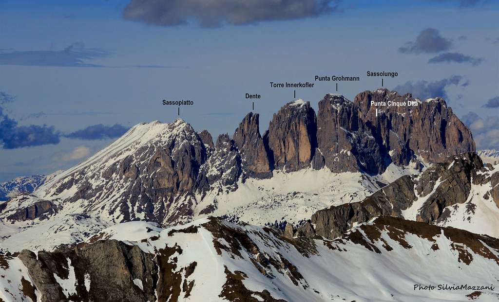
Here, on a thin little saddle, there's the end of the gully along which it develops the via ferrata Oskar Schuster. Beyond this little saddle, climb up on easy rocks the few meters that remain and soon reach the summit cross of Sassopiatto m. 2958. The landscape is wonderful, dominated to the east by the nearby Sassolungo, with Cinque Dita, Torre Innerkofler, Punta Grohmann and Dente del Sassolungo, to the SE Civetta and Marmolada, to the S Pale di San Martino, to the SW Catinaccio, to the W Sciliar and Alpe di Siusi.

|

|
Descent: reversing the same route
Essential Gear
Normal high mountain gear: hiking boots, backpack, sunglasses, gloves, cap, supplies, spare clothing.
Red Tape
No permits, no fees required
When to climb
Best period goes from middle June to middle September
Accomodation
Several possibilities of accomodation on Passo Sella and surrounding.
Bibliography
TABACCO N. 06 - Val di Fassa 1:25000
Meteo Forecast
METEO PROVINCIA BOLZANO ALTO-ADIGE