

-
 19359 Hits
-
 85.36% Score
-
 20 Votes
|
|
Route |
|---|---|
|
|
46.68099°N / 8.52790°E |
|
|
Trad Climbing |
|
|
Summer |
|
|
Most of a day |
|
|
5-/A0 or 6 |
|
|
Route Overview

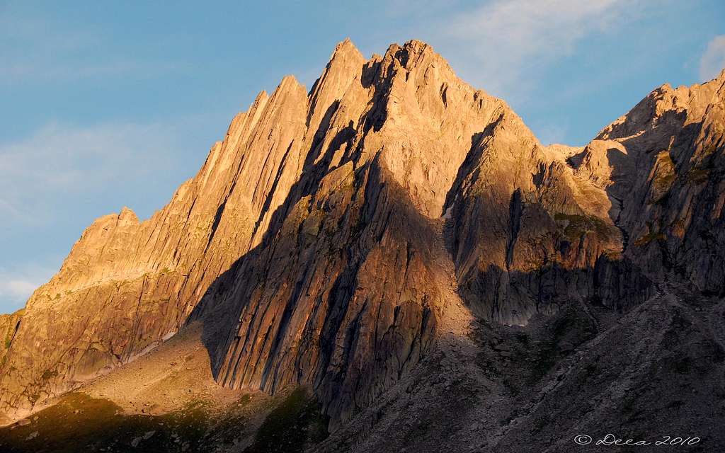
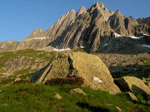
Salbitschijen
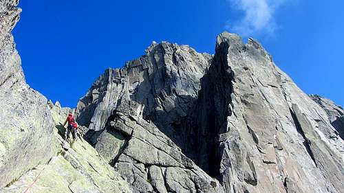
Salbitschijen 2981 m is a granite peak belonging to the Uri Alps and overlooking the Göschenental in the Swiss district of Uri, central Switzerland. It's a high class alpine rock destination, featuring the classic West and South ridges, plus many other routes accessible from the Salbithütte, renowned in reason of the excellent quality of its rough granite.
The South ridge of the Salbitschijen is characterized as one of the most beautiful climbs on a ridge of this difficulty on the whole Alps. The rock quality of the granit ridge is perfect and there are very impressive pitches. Together with the good protection (enough but not many bolts) and the great landscape this is a route I would recommend to everyone who's able to climb it.
Getting there
Road access
The main town in the area is Andermatt, a little town lying at St. Gotthard Tunnel northern exit. Andermatt can be suitably approached:
- From the Wallis via Sion, Brig, Gletsch and Furkapass
- From Luzern via Altdorf
- From Bern via Interlaken , Meiringen, Grimselpass, Gletsch and Furkapass
- From Milano (Italy) via Chiasso, Lugano, Bellinzona and the St. Gottard Tunnel
- From Chamonix (France) via Martigny, Brig and Furkapass
From Andermatt follow the road towards Göschenen (5 Km. from Andermatt); in Göschenen turn to left, leaving the main road, and follow the road rising along the Göschenen Valley. Follow the road and pass some houses, until you reach the Ulmi parking lot on the left at about 1195 meters of altitude, in front of a wood with a signposted pole (Salbithutte). No parking fees, no road toll.
Walking approach
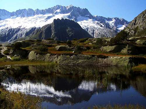
A well worn but steep path starts from here and with a 900 m vertical gain leads to the Salbit Hut SAC (Swiss Alpine Club), 2105 m, open in summer, situated near Salbitschjen.
Route Description
Salbitschijen S ridge report - UIAA scale
Summit altitude: 2981 m
Difficulty: D sup, V+
Equipment: pegs
Climbing length: 500 m.
Exposure: S
First ascent: A. and O. Amstad, G. Masetto 1935
Starting point: Salbit Hut SAC m. 2105
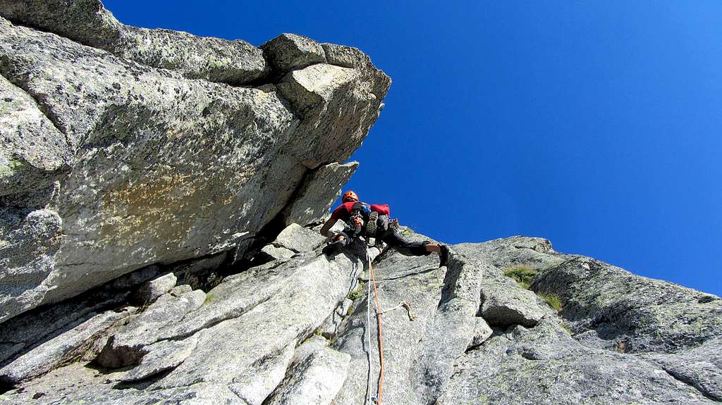
The route consists of 18 pitches. The difficulties are concentrated in one pitch (the 6th, can be aided at 5-/A0), the rest of the route is about 4+ with some moves of 5-.
Approach
Start at the Salbithütte (SAC, 2105 m). Take the well marked path direction Salbit-Biwak. This path leads one to the base of the so called Salibtzahn, a big tower at the beginning of the S-ridge of the Salbitschiijen. Before one reaches the base of the Salibtzahn turn right (path) to reach the base of a grassy gully at the E-flank of the S-ridge. Scramble up this gully (delicate) to the start of the route (1-2 hours from the hut).
The first 4 pitches are leading to the top of the Salibtzahn. From the top of this rappel 20 m. Following the ridge for 4 other pitches brings one to the base of the crux pitch. After a small, exposed notch a steep wall have to be climbed. This is done using a crack leading left to the crest of the ridge. Climb at the crest for some meters to reach easier rock. This pitch is rated 5+/A0 at all guide books I'm knowing. But all people I talked about this pitch are thinking, that this is harder (if you do not aid). So I suggest 6 as a free-rating for this pitch.
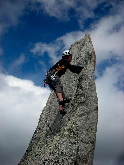
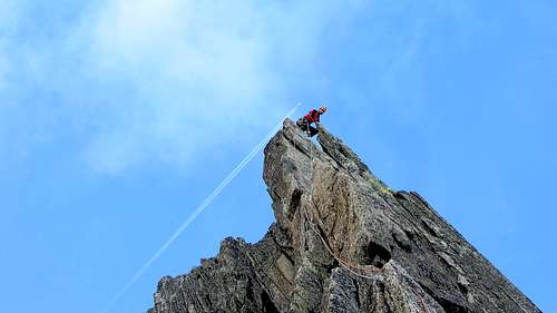
After the crux continue for 3 more pitches to the top of an tower. Stay left in general for this three pitches. From the top of the tower rappel 15 m to a notch, then continuing for one pitch to the top of the so called Zwillingsturm. From the Zwillingsturm rappel 45 m to a saddle below the final part of the S-ridge. This last part is climbed on the left hand of the ridge himself, following a system of cracks. Finally one reaches the summit, there the famous summit needle is waiting.
The summit needle is climbed at the east face in a 15 m pitch. At the top there is a bolt, use this to rappel from the needle.
L1, IV, 30 m - Climb the left side of the dihedral, then on grass and rocks up to the belay to the right.
L2, IV+, 30 m - Climb a slab and continue on a small dihedral up to the belay.
L3, V+, 40 m - Cracks up to an overhang to be overcome directly. More easily up to the belay at the base of a slab.
L4, V, 35 m - Directly climb a wall, then reach the base of the next wall cut by a crack. Climb the crack with a delicate passage, then traverse left. Stand just beyond.
L5, IV, 45 m- Traverse to the right following an inclined plane with a thin crack to a characteristic tower. Cross over to its base by walking, until the belay behind the corner. You are on the top of the Salbitzahn. Descend on the west side with a short abseil. Then go up briefly on easy rocks and grass to the fork (Zahnscharte) at the base of the next rocks on the ridge, where it's located the belay.
L6, IV+, 40 m - Keeping the left of the ridge climb some easy rocks that lead to a fork; traverse on the East side and horizontally follow a beautiful technical slab in adherence plate. Belay just above.
L7, V+, 40 m - Climb up beautiful cracks and blades, then enter a dihedral on the right, to be climbed up to go up to a fork. Now climb a slab to the right with blades leading to a good belay.
L8, V+, 30 m - Pass an easy outcrop, then turn left around a small tower and reach the following beautiful wall on the ridge. Follow the cracks on the left and a blade, reaching a belay.
L9, V, 30 meters: go up through the crack on the left of the next tower, then for more vertical rocks on the right and blades. Do not stop at the first stop you find, but continue for the first dihedral with fissure on the left of the stop, until you reach a comfortable stop.
L10, IV+, VI+ or V+ and A0, 40 m - Crux pitch of the route. Climb the wall above the belay reaching a notch, then downclimb on easy rocks. Climb the next wall until you reach a blade to the left. Climb a few more meters holding the blade, then traverse left inside a dihedral-crack. Climb it with a difficult move in the middle, then on easier rocks up to the belay.
L11, V-, 35 m - Head to left and climb on easy rocks, up to a dihedral to climb, exiting on the right to a slab with blades leading to the belay on the terrace.
L12, V, 45 m - Climb up a little above the belay, go down briefly to a notch and gain the opposite wall, to climb a beautiful rocky tower. Getting a fix traverse left without reaching the top of the tower, skirt the tower and climb up the next wall on dihedral and cracks, to the belay on the top of Plattenturm. Cross the ridge on the right with a brief pitch (IV), until you reach the abseil anchor. Abseil on the north side, to a belay on the notch between the Plattenturm and the Zwillingsturm.
L13, IV+, 30 m - Climb the S edge of the Zwillingsturm on blades, then cross to the right to reach a belay on a slab.
L14, IV+, a move of V, 25 m - Up the wall above the belay, taking advantage of the blades on the left, then traverse right towards an area of easy rocks. Now continue on the right side of a small tower, ignore a belay and after a notch reach a belay with the route-book. You can continue directly a few meters to find the belay with an abseil anchor. Abseil down to the base of the Zwillingsturm, north side, bypassing the next tower on the left. Reach the large terrace under the end wall.
L15, IV-, 30 m - Climb a slab near an edge up to a good belay.
L16, V+, 35 m - Climb the crack on the left of the belay, up to easy rocks and head slightly to the left to belay on a good ledge.
L17, V+, 40 m - Traverse left on a ledge and easy rocks, until you reach two parallel cracks-blades, to be followed up to the summit terrace at the end of the route.
To climb the Fiamma, the summit needle that constitutes the highest point of the Salbitschijen, continue until you pass under a large boulder and from there go left up to the base of the needle, belayong on the South side (I/II ).
L18, IV+, 10 m - Climb up keeping the right side, first on the slab, then with a technical move hold the blade and reach the top, 1 peg.
Descent: following the regular route, this will take about 2 hours from the summit to the hut. Caution: the descent route follows a couloir often snow covered, below the snow there is a creek. An ice ax and crampons can be useful at the beginning of the season. The descent path is on the right boundary of that couloir (there is a good path). Don't take the middle of the couloir. From the last belay under the Fiamma continue on easy rocks to the left until you see some red marks indicating the descent. The stamps follow rocks and debris on the north side, sometimes exposed and equipped with metal ropes, towards the right (facing in). Go down towards a couloir, until you reach it near the beginning of a steep section. Here a path leads to the base of the couloir and just. Crossing the creek towards the left and follow the path to the hut.
Pay attention to the conditions of the rocks: in case of snow there are several exposed and non-trivial sections.
Essential Gear
Ropes 2x50m, some friends, slings, helmet, some rocks
Red Tape
No particular restrictions in climbing and hiking.
Huts
Salbit Hüt 2105 m
Size: 60 places
Owner: Swiss Alpine Club
Phone info: 0041(0)41 887 00 60
Take the train to Göschenen (northern station of the Gotthard railroad and automobile tunnel), walk 1 mile into the Göschener valley as far as Abfrutt (1195 m). You can park the car here, no fees. The cable car that goes half way up to the Salbit hut and is for cargo only; you can phone and let your rucksack (especially skis in spring!) transport up to 1680 m. The path to the hut is well marked and easy to find. This hut is suited for all Salbitschijen climbs, except for the west ridge. In spring it is a starting point for the Rorspitzli (3220 m) with descent to Meien (1300 m). 3 hours. Hiking path.
Salbit bivouac 2402 m
Size:12 persons, no water (luckily some snow), blankets, nothing else. Phone info: ++41(0)41 820 05 68. Link Take the car or bus (reservation ++41(0)41 885 11 80 from Göschenen as far as the entry of the Voralp valley. Follow the path to the Voralp hut. At Alp Horefelli ( 1786 m) turn east and follow the marked path north of Spicherribikehle. Climb the saddle at point 2202 m. Then go back to the huge couloir, climb 100 m, and turn south, reach a saddle at 2300 m. 100 m higher at the foot of tower I of the west ridge is the bivouac. II, III. 4 hours from bus station Voralp.
The bivouac can also be reached from the Salbit hut over the Zahnscharte (2710 m) of the Salbit south ridge. From the saddle go down and keep always somewhat to the right. You can see now all 5 towers, Tower I, where the hut is, is the lowest. Rappel.
When to climb
Best season goes from July to September.
Meteo
Guidebooks and maps
- Guidebooks
 |
 |
- "Schweiz Plaisir Ost" by Sandro von Känel - Edition Filidor 2015
- "Schweiz Plaisir Ost" by Jurg von Kanel - Edition Filidor
- “Arrampicare in Svizzera” Ed. Versante Sud
- "SAC Guidebook - Urner Alpen" by T. Fullin - A. Bahnholzer
- "Ascensioni scelte nella Svizzera Centrale" - Franco Malnati 1981
- Maps
Swisstopo - 37 - Brünigpass Swisstopo - 255 - Sustenpass Swisstopo - 1211 - Meiental