
|
|
Mountain/Rock |
|---|---|
|
|
40.79967°N / 107.15223°W |
|
|
Routt |
|
|
Hiking, Mountaineering, Trad Climbing, Toprope, Bouldering, Scrambling, Skiing |
|
|
Summer, Fall |
|
|
10057 ft / 3065 m |
|
|
Overview-Colorado's Forgotten Mountain Range
When viewed from certain angles, Saddle Mountain is perhaps the most dramatic peak in the Elkhead Mountains, though this is dependent on which direction you are viewing the peak from. The mountain itself is a volcanic dike that forms a long ridge with steep sides. No trails approach the peak and it was perhaps a bit more challenging than expected, even though the difficulty on the easiest routes never really exceeds class 2+.
By Elkhead Mountains standards, Saddle Mountain is “average” in popularity of how frequently it is climbed. We were the first to sign the register (which I replaced with a sturdier container) in two years, but on the other hand two other people met us on the summit, which is a rarity in the Elkhead Mountains (other than perhaps two or three summits). Saddle Mountain is not climbed as often as nearby peaks such as Hahns Peak, Sand Mountain or Bears Ears, but is climbed more frequently than nearby peaks such as Mount Oliphant or Buck Point. Some of the signatures in the register date back to at least 1974, but there may be some older than that that are illegible. The peak is one of the more challenging of the 10,000+ foot peaks in the Elkhead Mountains.
Several aspects of the Elkhead Mountains make this a rather unique mountain range in Colorado. It is certainly possible that the Elkhead Mountains are the least known of the major mountain ranges in Colorado. This is partially because the range is a long way from any metropolitan area, and partially because the Elkhead Mountains are fairly low by Colorado standards, as there are no peaks reaching 11,000 feet. There are also few lakes, so the range isn’t visited by fishermen. Despite their low altitude, the Elkhead Mountains receive much snow, and snow lasts into July or later on the higher peaks. Most of the peaks in the Elkhead Mountains see very few ascents, but Hahns Peak, the eastern-most peak in the range is a popular climb for residents of Steamboat Springs. The Bears Ears see quite a few ascents by Elkhead standards, because of their prominent shape and visibility from the Yampa River Valley. Black Mountain is also climbed fairly often because it is the highest point in Moffat County, and the popularity is on the increase with more county highpointing interest. Sand Mountain must be a fairly popular (by Elkhead standards) climb as well, as there is a trail to the top, and as it is the first mountain in the range where I have ever met anyone. This was on Labor Day weekend, 2005, when we saw 3 other hikers. I met two hikers on Saddle Mountain on July 5 2010. Other than those two exceptions and on Hahns Peak, I have never met other climbers while climbing any of the peaks in the Elkhead Mountains. Most of the rest of the peaks see few ascents, and one ranger has told me some of the peaks only have a few names in the registers since 1980. So, there are few hikers around, but hunting is another story. The Elkhead Mountains are very popular for hunting in the fall and contain large populations of deer, elk, bear, etc.
One thing unique about the range is that hiker use is overall actually decreasing, rather than increasing as it is in most places in Colorado. The summit registers (which the Forest Service keeps record of) on most peaks indicate that they have had more ascents in the 1960’s and 1970’s than they do now. Even before that, there were many summit logs from the 1930’s and 1940’s from sheepherders.
The Elkhead Mountains are made of old volcanic rocks 17-25 million years old. One thing unusual is that the Elkhead Mountains run west to east as opposed to north and south as most of the ranges run in North America. It is impossible to describe the general forms of the peaks because they are all so different, but most of the peaks are isolated rises from a huge plateau which forms the bulk of the Elkhead Mountains.
Elkhead Mountains-10,000+ Foot Peaks with 300+ feet of Prominence
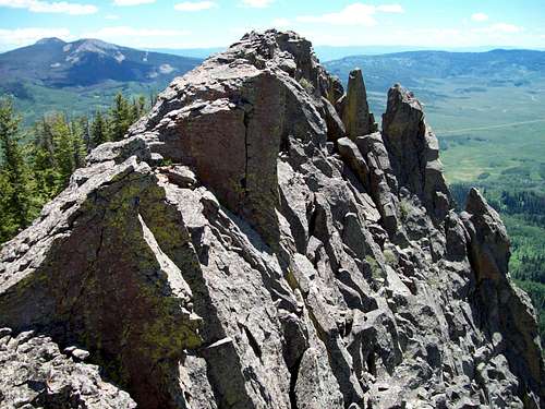 This is the summit of Saddle Mountain.
Navigational Warning
Warning:
The topo maps available don’t show the roads or trails around this mountain accurately (though the main California Park Road is pretty close). The closest one that bears resemblance to reality is the Forest Service Map-Routt National Forest, but it is of a small scale. The USGS maps don’t show many of the roads in the areas, but seem to show roads and trails that don’t exist; at least not any more.
Update:
The USGS has (finally) updated the 7.5 minute maps. They were scheduled to be produced for Colorado last year, but I’m not sure when they will hit all the stores. Right now you can get/see/print/buy the new 7.5 minute maps on My Topo.
The good news is that all the roads and trails are FINALLY accurate for the Elkhead Mountains (and undoubtedly other areas as well). After receiving the new maps, I am very pleased to see that the roads and trails are in the right places. I am also very pleased that the USGS has a new agreement with the US Forest Service and within the national forest service areas, the private land holdings are shaded (but only in USFS areas, land ownership is not shown outside FS lands) on the 7.5 minute scale maps.
Getting There
From Walnut Street in Hayden (on Highway 40 between Craig and Steamboat Springs), turn north on Walnut, a.k.a. County Road 76, and follow it north for 0.7 miles to County Road 80. Turn right on (gravel) County Road 80 and follow it past the California Park Guard Station. There are several possibilities of where to park (since there is no official trailhead), but we parked at the small saddle marked Elevation 8270 on the topo map. This is 1.2 to 1.3 miles north of the Guard Station turnoff.
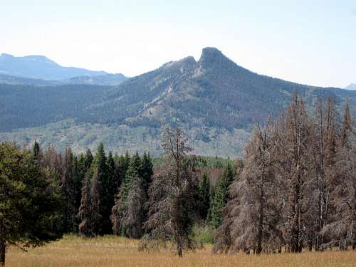 Saddle Mountain as viewed from the east.
Routes Overview
There appear to be several route possibilities available on the mountain, but I’ve only climbed the Southeast Ridge, which may be the most practical route up the mountain. The route is steep , slippery and tedious in places and can have some minor bushwhacking, but the difficulty never exceeds class 2+. See the route page below:
Saddle Mountain via Southeast Ridge
From the summit register, others have climbed the peak from the north, which appears to be a steep, but non technical route.
The south side of Saddle Mountain forms a cliff face. By Elkhead Mountains standards, the rock appears fairly solid (which is a relative term in the Elkhead Mountains) when compared to other peaks in the range. This may be the only peak in the Elkhead Mountains which is practical for rock climbing, but don’t expect basalt to be the same as solid granite.
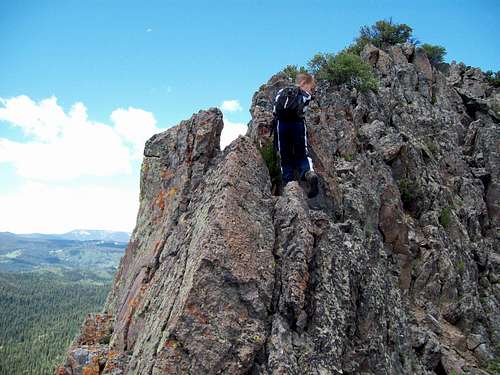 Kessler nearing the summit of Saddle Mountain.
Red Tape
There is no red tape, but make sure to tread lightly.
 There is no red tape in these mountains.
Camping
There are many excellent campsites along the road to California Park after you reach the forest boundary. The road is closed until July 1 each year.
When to Climb
July through early September could be considered the normal season to climb the mountain. The access road doesn’t open until July 1, but the roads could certainly be walked, snowshoed, or skied before then, though it would be a long haul. The Elkhead Mountains are a very popular hunting destination in September and October (until snow closes the road), so use extreme caution at this time of year. In winter, this mountain is a fair distance from the road closure, climbing the peak would require at least two days, maybe three (unless you have access to a snowmobile).
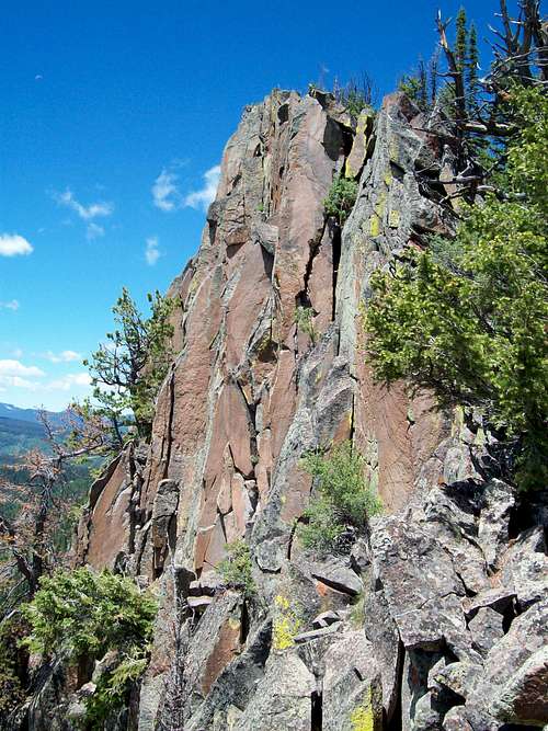
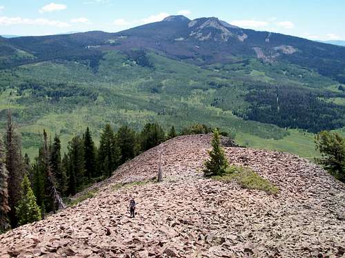 Kessler on the SE Ridge of Saddle Mountain in July.
Mountain Conditions
CLICK HERE FOR THE MEADEN PEAK WEST AREA WEATHER FORECAST
Below is the National Weather Service Climate Summary of Steamboat Springs. The data is from 1908-2005. This is the closest long term weather station, but be aware that higher elevations will be much wetter and colder. Steamboat Springs is at 6695 feet elevation, so expect the temperatures on Saddle Mountain to be 10-20 degrees colder than in Steamboat (except for cold winter nights).
| MONTH | AVE HIGH | AVE LOW | REC HIGH | REC LOW | AVE PREC (in) |
| JAN | 29 | 1 | 57 | -54 | 2.47 |
| FEB | 34 | 4 | 59 | -48 | 2.24 |
| MAR | 42 | 13 | 70 | -34 | 2.11 |
| APR | 54 | 24 | 79 | -15 | 2.28 |
| MAY | 65 | 31 | 88 | 8 | 2.08 |
| JUN | 75 | 36 | 96 | 19 | 1.49 |
| JUL | 82 | 41 | 97 | 25 | 1.54 |
| AUG | 80 | 40 | 98 | 20 | 1.60 |
| SEP | 72 | 33 | 93 | 6 | 1.81 |
| OCT | 60 | 24 | 89 | -16 | 1.89 |
| NOV | 43 | 14 | 72 | -28 | 1.97 |
| DEC | 31 | 3 | 64 | -44 | 2.38 |