-
 5366 Hits
-
 86.37% Score
-
 22 Votes
|
|
Mountain/Rock |
|---|---|
|
|
42.39126°N / 8.90307°E |
|
|
Corsica, Corse |
|
|
Mountaineering, Trad Climbing, Scrambling |
|
|
Summer, Fall |
|
|
7057 ft / 2151 m |
|
|
Overview
Punta Stranciacone 2151 m
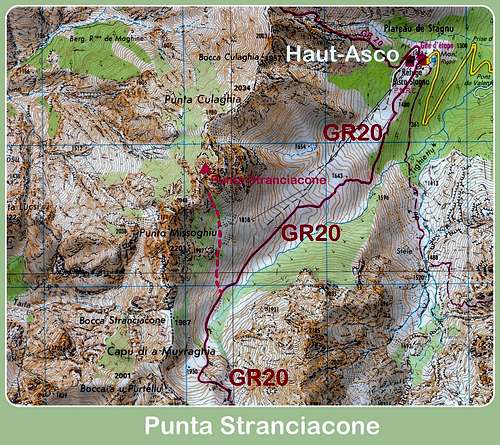
Among the Corsican valleys, the Ascu Valley is one of those that have the strongest alpine character with high mountains and an exciting landscape, full of dense pine forests, streams and little lakes. In addition, the Ascu valley provides an important way to penetrate the heart of the central mountain massif, where we can find the highest summit of the island, Monte Cinto m. 2706. The road D147 leads to the ancient Haut-Ascu ski resort, which is no longer active. Driving along the D147 road across the winding Ascu gorges, wet by the thundering Ascu river, which flows with crystal clear waters through the cliffs and gorges and gives the name to the valley, is truly an attractive trip. A pretty peak lies to the SW of the Haut-Ascu resort, between Punta Missoghiu and Punta Culaghia: it’s Punta Stranciacone.
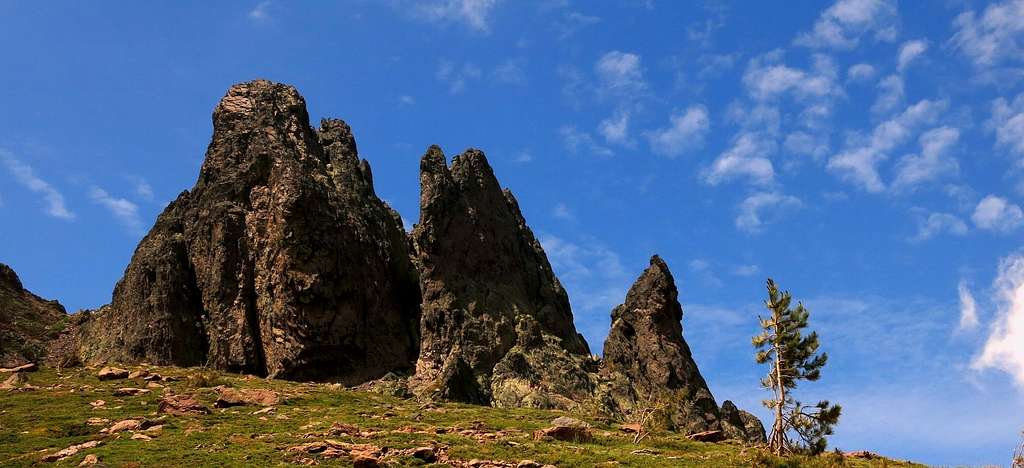
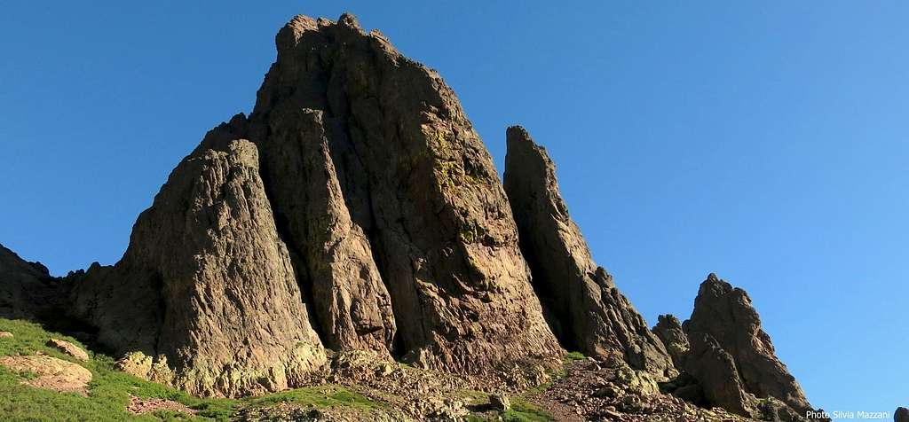
Punta Stranciacone is in fact not a single point, but three parallel blades forming a group of points. The Eastern blade carries the Eastern summit, the middle blade carries the central one and the Western blade carries the South and West ones. This latter is the highest point of the peak. It’s the stunning South Face to attract the climber, while the Western summit is an interesting goal for the experienced hiker. In fact, the Normal route to reach the summit of Punta Stranciacone provides a nice and easy scramble, gaining the Western Summit, the highest one, which gives one of the most beautiful views of the island toward the Mediterranean Sea.
Getting There
Access to Corsica
The island of Corsica can be easily approached:
- by ferry-boat; there's a lot of possibilities from the French ports of Marseille, Nice and Toulon or from the Italian ports of Livorno, Genova and Savona (the main Corsican ports are Ajaccio, Bastia and Calvi). Anyhow the shortest way to getting there is to take the ferry from Livorno harbour on the Italian Western coast to Bastia harbour on Corsica Eastern coast.
- by plane; main Corsica airports are Bastia, Ajaccio, Calvi and Figari.
Road approach
The most convenient destinations to start the trip to Ascu Valley are Bastia or Ajaccio. The closest town to the Ascu Valley is Ponte Leccia.
- from Bastia (Corsica East coast) take the road N193 (70 km)
- from Ajaccio (Corsica West coast) take the road N193 (80 km)


Road approach to Haut - Ascu
From Ponte Leccia follow the road N197 to Calvi and after 2 km turn to left, taking the road D147. Drive to South-West on the narrow and impressive road, penetrating within the Ascu valley. After about 18 kms you will reach the small settlement of Ascu m 600, the unique village of the valley; the road penetrates within the beautiful Forest of Ascu and after some hairpins reachs the ancient ski-station of Haut Ascu m 1422 on the Stagnu “plateau”. Parking.
Punta Stranciacone routes overview
Normal route to Western summit
Summit altitude: m 2151
Difficulty: Alpine PD
Exposure: North First ascent: Felix von Cube & Co. 1902
The normal route climbs an easy gully on the Northern side, gaining a double rocky saddle and the Western summit, the highest.


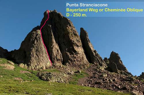
South Wall - Bayerland Weg or La Cheminée Oblique report - UIAA scale
Summit altitude: m 2151
Difficulty: Alpine D, UIAA max V+
Route length: 250 m
Exposure: S First ascent: H. Clauss and H. Karasek 1969, August 7th
Starting point: Haut Ascu ancient ski resort
This pleasant route, not to be underestimated, has been named "Bayerland Weg" by the first climbers, while the local ones know it as "La Cheminée Oblique". It doesn't mean, it's the most classic route of the wall and the most recommended, following an aesthetic line inside a system of dihedrals and chimneys slanting left, from which the French name of the route, up to a shoulder, from which it returns to the right following a direct line along a series of corners and chimneys.
Approach - From the Haut-Asco station head to SW, walking along the ancient ski-track to reach the GR20 red and white marks, rising inside the "pino laricio" forest to a large "plateau". Leave the main path and walk up on the slopes on the right heading to the obvious peak. The starting point of the route is below a large chimney on the left of the wall.
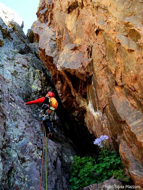
Coloured chimney along "La Cheminée Oblique" |
A chimney on "La Cheminée Oblique" |
Route report
L1 - Attach the left chimney with a great pitch 50 meters long, IV+, 2 pegs
L2 - Another 50 meters pitch, unusual in reason of a ride behind a big block, leads to a terrace, IV+. Belay on a rocky beak on the right. We are thus faced with a dihedral. Two possibilities:
L3 – L4 Climb the dihedral and then gradually move to the right, crossing two large gullies with some cunning and difficult moves V+. Alternatively head soon towards right in order to reach a couloir-chimney V
L5 - Climb the rightmost dihedral, leading to the stance. V
L6 - Climb now a new couloir IV +
L7 - The last obvious dihedral leads to the top IV+
Another interesting route, more difficult than the previous one, is the Audibert or Cheminée Centrale, TD-
Descent: Head to the North to a rocky saddle, downclimbing or alternatively with a short 10 meters abseil. Hence 3 rappels of 25 meters each, leading to a slope of debris and vegetation that is followed on the GR 20 trail. Follow it to the left (South), then skirt the wall and return to the base of the route.
Red Tape
No fees no permits needed. Wild camping is strictly prohibited in Corsica.


The Haut Asco area is located inside the Parc Naturel Régional de Corse P.N.R.C. (Natural Regional Park of Corsica), which since the year 1985 has been acknowledged as “Great National Site”. Its 33,000 hectares' extension includes 143 communes and fills beyond 1/3 of the island’s territory.
Nature and climate

Nature is wild and peculiar. In Corsica we can find more than 5% of authoctonous kinds of flower and plants, in addition to authoctonous fauna. On the contrary, several kinds of animal current inside Mediterranean countries are away from Corsica, like squirrels and vipers.
Climate is alpine, with cold and very snowy winters. The full summer months (July and August) sometimes may be hot.
When to Climb
Best season goes from the end of June to middle October
Campsites and accomodation
- Hotel Restaurant Gite "Le Chalet" - Haut Asco
- Refuge Stagnu - Haut Asco
- A couple of hotels in Asco
Campsites
At Haut-Asco basic camping is possible, otherwise there are different equipped camp-sites along the Asco Valley; the closest is Monte Cinto Camping, located within the Haut Asco Forest, between Stagnu and the village of Asco
Meteo
METEO CORSE
LACHAINE METEO ASCO
Guidebooks


"Guide d'escalade en Corse - Corse du Nord", Tome I by Jean Paul Quilici and Bernard Vaucher, Ed. de l'Envol, 2000, in French
"Corse, l'ile verticale" by Martial Lacroix e Pierre Sanchou, Ed. Adrénaline, 1999, in French. A selection of 72 beautiful multi-pitches in Corsica, in French
"Corse paradis de l’escalade" by Martial Lacroix, DCL Editions, in French
Maps
"Monte Cinto" IGN OT4250 1:25.000
"Corse du Nord" sheet 20 1:50 000, Ed. Didier Richard