
-
 5859 Hits
-
 82.48% Score
-
 15 Votes
|
|
Route |
|---|---|
|
|
47.06910°N / 12.24100°E |
|
|
Mountaineering, Ice Climbing, Mixed |
|
|
Summer |
|
|
A long day |
|
|
Alpine AD-, UIAA III+, 45° |
|
|
Overview
Picco dei Tre Signori/Dreiherrenspitze North-West Ridge
Picco dei Tre Signori (Dreiherrenspitze) is a mighty and complex mountain, the highest one of the whole Alpi Pusteresi, lying on the boundary ridge between Italy and Austria and rising at the head of Valle Aurina/Ahrntal, the Northernmost valley of Bolzano Alto-Adige province. This beautiful mountain, often attended along both the two Normal routes situated on the West side (Valle Aurina, Italy) and on the South-East side (Maurertal, Austria), shows on the Italian side a fine and long ridge facing North-West. The route running on this ridge is a classic and very interesting ascent, one of the finest routes of the whole group, involving a various ascent inside a wild and superb environment. The route can be approached from Rifugio Brigata Tridentina, Valle Aurina/Ahrntal.
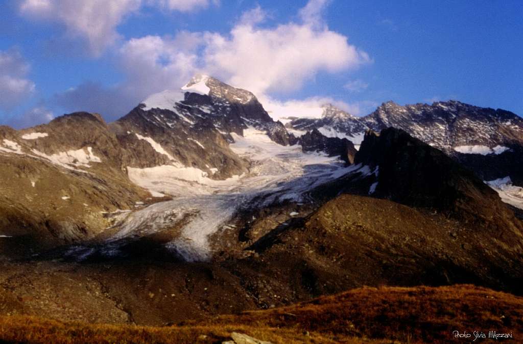
Picco dei Tre Signori at sunset
Getting There
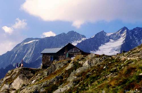
The shelter at 2441 m. (Rifugio Brigata Tridentina)
Road Approach
The starting point is the little village of Pratomagno/Prastmann m. 1623, km. 27 from Campo Tures, the most important center in Valle Aurina/Ahrntal.
Getting to Valle Aurina/Ahrntal - From Bolzano: take the Brennero Motorway, exit Bressanone and follow the road SS 49 along Val Pusteria, getting to Brunico; in Brunico leave the SS 51 and take the road SS621 to Campo Tures, Lutago, San Giacomo, Casere and Pratomagno (70 km. from Bressanone exit).
Walking Approach to Rifugio Brigata Tridentina m. 2441
From Pratomagno/Prastmann m. 1623 follow the narrow unsurfaced road rising towards the head of the main valley, crossing the Trinkstein marshland. Pass the ruins of a little barracks, getting to a fork (signposts). Leave the path n. 14 on your left hand and carry on along the narrow road, turning to NE and skirting the Aurino River, then reaching the meadows of Malga della Svolta/Kehreralm m. 1842. Cross the grassy basin, then take a good path rising with some hairpins to the grassy terrace of Malga Lana/Lahneralm m. 1979. Walk along the wide terrace, crossed by the Aurino stream, getting the bottom of a steep slope. The path rises on the slopes with several hairpins, then heads towards right, exiting to the little grassy terrace on which lies the Rifugio Brigata Tridentina. From 2,30 to 3 hours from Pratomagno.
Route Description
Dreiherrenspitze North-West ridge report - UIAA Scale
Summit altitude: m. 3498 Difficulty: Alpine AD-, III+ UIAA, 45° Difference in level: 1875 m. from Pratomagno, 1057 m. from Rif. Brigata Tridentina Equipment: rare pegs along the rocky pitches Exposure: NW First ascent: F. Drasch – J. Ensmann 1891, September 13th Hut: Rifugio Brigata Tridentina m. 2441 Starting point: Pratomagno, Valle Aurina/Ahrntal m. 1623
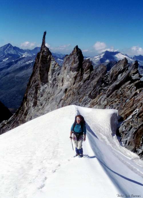
Dreiherrenspitze North-West ridge, running on the boundary ridge between Italy and Austria, is a complex route, involving both rock and ice climbing. The difficulty doesn't exceed the III+ grade UIAA, but the length of the route imposes good conditions of the rocky ground and very good weather forecast.
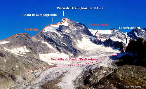
Picco dei Tre Signori/Dreiherrenspitze NW ridge-Italian Normal route traverse
Part I – Scrambling approach from Rifugio Brigata Tridentina m. 2441 to the Grasleitenschartl m. 2901
The Grasleitenschartl m. 2901 is a narrow rocky notch having an interest exclusively alpinistic lyging between Cima di Campogrande/Grasleitenkopf to North and Costa di ampogrande/Grasleitenschneide to SE. From the shelter take the marked path to the Vedretta di Predoi/Prettaukee; a bit before reaching the glacier, leave the main path and turn to left (East), scrambling up on scree and steep snow-fields and heading towards the upper saddle. Last meters are done climbing carefully a short but crumbling and sometimes snow-covered slope exiting on the boundary notch of Grasleitenschartl m. 2901. Another longer option to get the notch is climbing the rocks on the right.
The downclimb
A crazy needle on the descent route
Part II – Climbing section from Grasleitenschartl m. 2901 to the Summit snow-shoulder m. 3150
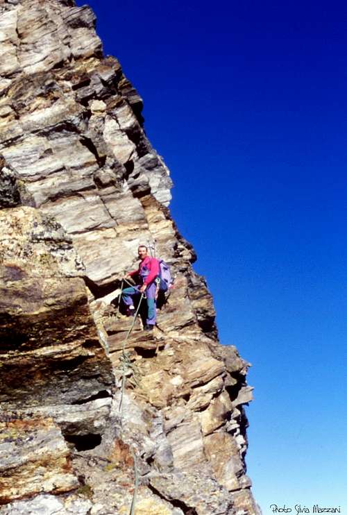
From the Grasleitenschartl m. 2901 head towards SE (left) climbing without particularly difficulties the first section of the boundary ridge, at first keeping yourself mainly on its edge. When the ridge is becoming steeper and more difficult, you must skirt it keeping a bit on the Austrian side (left), reaching a small terrace below a steeper and slabby rocky pillar (peg). Climb it slanting right, then return left on the edge of the pillar (UIAA III and III+). Up the edge on easier rocky steps (UIAA II), getting the summit of a rounded ice-cap at 3014 meters of quote. Downclimb the airy rocky walls below your foot or make one rap (one anchor in place) getting to a deep and narrow rocky notch below a rocky ridge. Up the ridge with pleasant climb (UIAA II and III), getting to the upper snow shoulder at 3150 m.
Part III – Ice -climbing section from the upper snow-shoulder m. 3150 to the summit of Picco dei Tre Signori/Dreiherrenspitze m. 3498
From the snow-shoulder traverse the summit of Costa di Campogrande m. 3266 and carry on the snowy NW ridge of Picco dei Tre Signori reaching the bottom of a wide and steep 100 meters high ice-slope. Climb it, heading towards a rocky and scree ridge, rising to a snowy terrace. Up a another easier ice-slope, then climb the last easy rocky steps leading to the superb summit.
Part IV – Descent on Picco dei Tre Signori/Dreiherrenspitze Italian normal route
The descent is made following Picco dei Tre Signori Italian normal route. From the summit downclimb on easy rocks getting to the wide and snowy SW shoulder of the peak. Here (at about m. 3335) head to right – facing out – following towards SSW the track leading to the Rif. Brigata Tridentina, the starting point, while the left track (towards NNW) descents to the Rif. Giogo Lungo. After an exposed traverse on a wide snow-slope, downclimb on a steep ice-slope, ending at a huge bergschrund.


After skirting the edge of the bergschrund, reach the glacier named Vedretta di Lana/Lahnerkees and cross a crevassed zone. Turn to right to get the saddle named Lahnerschartl m. 2837, beyond which carry on traversing a second glacier, the Vedretta di Predoi/Prettaukees and reaching the moraine. On the moraine a good path starts (red-white marks), crossing some grassy slopes and getting to the hut.
Essential Gear

Rope, helmet, ice-axe, crampons, two ice-screws, a set of nuts, some ribbons, three-four quickdraws.

Red Tape

No particulary restrictions in climbing and hiking.
Hut
Birnlückenhuette/Rifugio Brigata Tridentina alla Forcella del Picco 2441 m
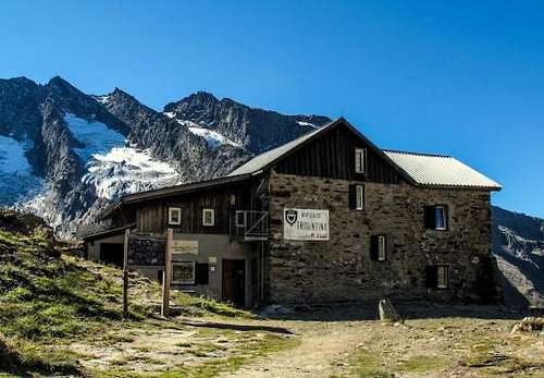
Rifugio Tridentina
Situation: Forcella del Picco/Birnlückenhütte
Open: from middle June to early October
Size: 45 persons
Guardian: Fam. Untergassmair
Refuge's phone: +39 0474 654 140
When to climb
Best period goes from July to September
Meteo
Meteo Bolzano Alto Adige
Meteo Alto Adige
Guidebooks and maps


Guidebooks
“Alpi Pusteresi” by F. Cammelli – W. Beikircher – Collana Guide dei Monti d'Italia C.A.I.-T.C.I.
Maps
"Ahrntaler Berge - I monti di Valle Aurina" map 1:25.000 - Mapgraphic Bolzano