
|
|
Mountain/Rock |
|---|---|
|
|
Mountaineering, Trad Climbing |
|
|
Spring, Summer, Fall, Winter |
|
|
13040 ft / 3975 m |
|
|
Overview
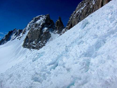
This awesome, two-headed spire is an excellent moderate alpine route from the east side of the Sierra. It involves trail and cross-country hiking through a beautiful valley, then cramponing up a 700' couloir, and finally rock pitches to a coffee-table-sized summit. Climb this before heading to the Palisade Glacier and the 14k peaks above it.
The Petit Griffon is visible on the Sierra Crest skyline from Rock Creek Lake but really comes into view at Ruby Lake. You are seeing the East summit from this direction. Most climbers top out on the higher West summit. View the enlarged version of the image below to see the two summits.
![Petit Griffon; East & West summits]() Petit Griffon; East & West summits
Petit Griffon; East & West summits
The Petit Griffon is visible on the Sierra Crest skyline from Rock Creek Lake but really comes into view at Ruby Lake. You are seeing the East summit from this direction. Most climbers top out on the higher West summit. View the enlarged version of the image below to see the two summits.
 Petit Griffon; East & West summits
Getting There
Sierra East Side, Tom's Place, up Rock Creek Rd, hike Mono Pass Trail, turn off to Ruby Lake, leave trail and skirt Ruby on the east, then cross-country to Mills Lake at 11,600'. The approach to Mills Lake will take 3-4hrs with heavy packs. The Griffon will be silhouetted on the skyline.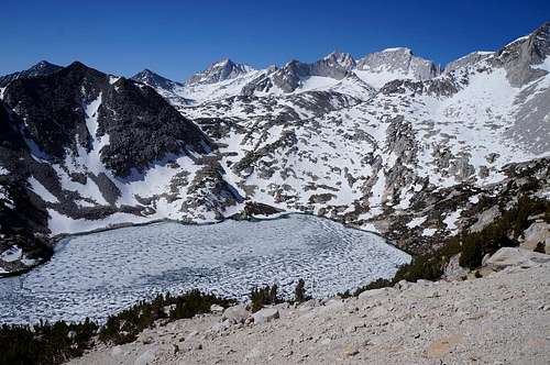 Ruby Lake with the Petite Griffon on the skyline
Route
There are a few routes up the to the West summit but I'm not yet aware of an East summit ascent. The spire does not get climbed a lot. I topped out in July of 2014 and no one had signed the summit register in 2 years. There is an orange Pelican box and 5 rap slings on the west summit block (July '14). Some of the slings need to be removed.Do not trust belay/rap anchors on the rock pitches. Inspect them and bring long slings to reinforce them.
The rap off the West summit to the couloir notch is ~180', so unless you have two 60M ropes, rap to the belay station at the top of P1 of the NW Side route, then do a second rappel.
If you've climbed the East summit, or other West summit routes; please add a route page.
Red Tape
If you are not acclimated and super fit you will want to bivy at Mills Lake. To do this you need a back-country permit which is available at the ranger station in Bishop or Mammoth. Permits are limited by a quota. Some can be reserved, and some are available first-come-first-served the day prior to entry. Call a ranger station or go to the Inyo National Forest website for the latest red tape & to reserve a permit.Camping
If you need to acclimate, car camp at Rock Creek Lake CG which is at 9,700'. Or you can camp at Mosquito flats "walk in" CG if you have a back-country permit for the next day (10,200'). You need to walk in about 50 yards from your car to do this. As of 2014, both these CGs are first-come-first-served. RC Lake is $21/night, Mosquito is free.
![Petit Griffon from Rock Creek Lake]() Petit Griffon from Rock Creek Lake
Petit Griffon from Rock Creek Lake
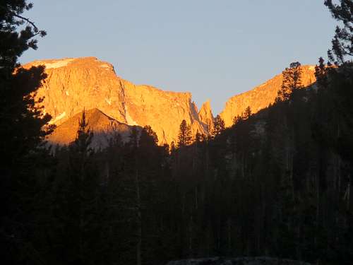 Petit Griffon from Rock Creek Lake
T. White - Sep 28, 2018 11:22 am - Hasn't voted
Lat/Long coordinates are offAccording to the provided coordinates, this spire is located way out in the Owens Valley!