
-
 9037 Hits
-
 82.48% Score
-
 15 Votes
|
|
Mountain/Rock |
|---|---|
|
|
40.02790°N / 9.70685°E |
|
|
Sardinia |
|
|
Trad Climbing, Sport Climbing, Scrambling |
|
|
Spring, Fall, Winter |
|
|
420 ft / 128 m |
|
|
Overview
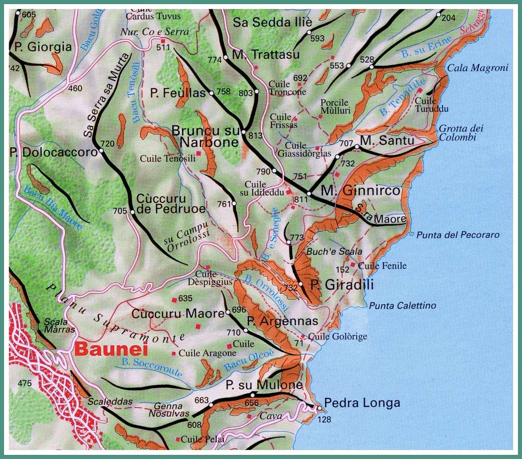
Geographical classification: Sardegna - Sardinia > Supramonte > Aguglia di Goloritzé
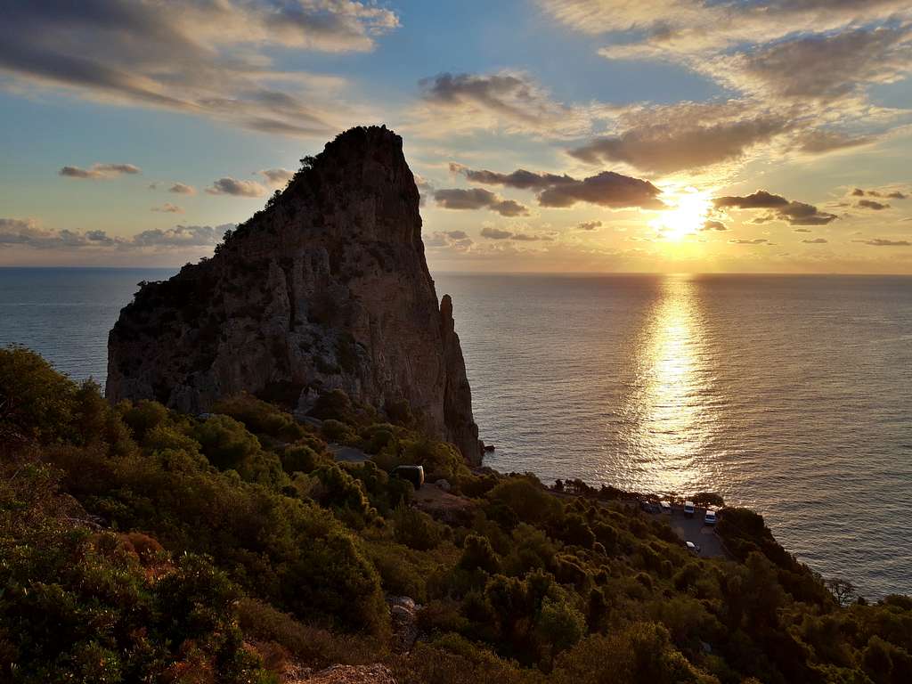
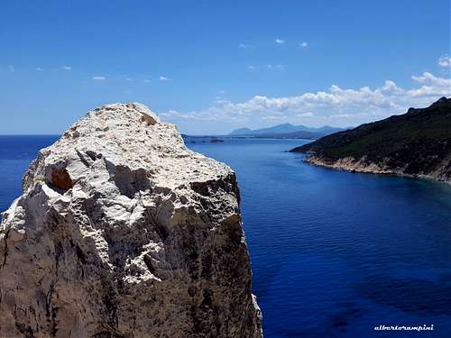
Pedra Longa
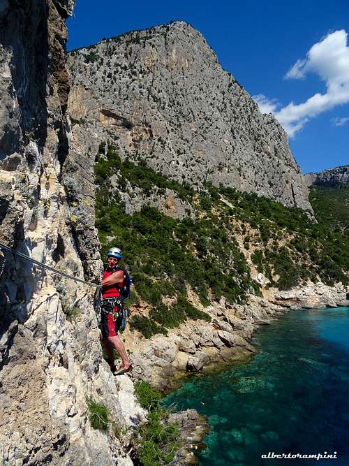
Pedra Longa, also known by the name "Agugliastra", is a gigantic monolith located in the last foothills of the Supramonte di Baunei, inside the Parco nazionale del Golfo di Orosei e del Gennargentu, a 128 m high spire rising above the sea, isolated and protruding from the coast. It is part of the limestone plateau of Baunei which covers a vast territory, along a strip which, starting North to the Codula di Luna extends itself until the village of Santa Maria Navarrese to the South. This plateau, shaped over time by karst phenomena, near the coast abruptly interrupts its development forming a gigantic wall several tens of kilometers long, which includes the high walls of Punta Giradili, Punta Argennas and Monte Ginnircu in the southernmost stretch.
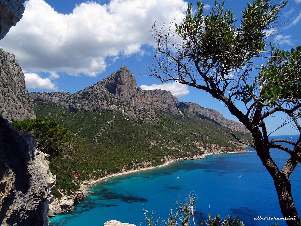
Immediately after it follows Perda Longa, the last rocky attraction of the long and high cliff, which despite its decidedly smaller size than the imposing rocky structures that surround it, definitely attracts attention as the remarkable landscape attraction of the place. Pedra Longa is a highlight of the island, in fact it was declared a natural monument in the year 1993. According to some historians, the name Ogliastra, the region surrounding the spire, just derives from "Agugliastra", the historical toponym of Pedra Longa. This ancient name used by sailors in past ages, gives the idea of its slender shape, widened at the base and tapered upwards. Despite the short approach - can be reached by car via a municipal road that connects it to the state road 125 Orientale Sarda - it is decidedly less crowded than the nearby Aguglia di Goloritzè.
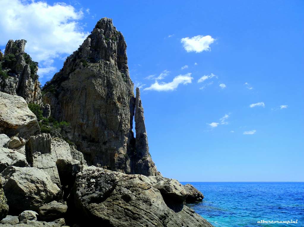
The quality of the rock, although good, is decidedly different from the Aguglia di Goloritzè and the rocky structures and cliffs of the area: it is a dolomite not always very solid, instead of the very solid and compact gray limestone of Goloritzè. Despite this, there are advisable and interesting itineraries, on which climbing is very pleasant for the beauty of the place but also for the quality of the rock.
Getting There
Access to the island of Sardinia
Sardinia, the Westernmost region of Italy, can be reached by plane or by ferry-boat from Livorno, Civitavecchia and Genova harbors. The most convenient destination in Sardinia to visit the Supramonte di Baunei, one of the wildest region of the island, is the airport of Olbia if you’re getting there by plane; the same Olbia or the near Golfo Aranci harbors if you’re getting there by ferry-boat.
Best starting points to approach Pedra Longa are the villages of Baunei and Santa Maria Navarrese.
Road approach
From Olbia or Golfo Aranci, situated just a few kilometers North to Olbia, follow the quick Motorway SS131 towards Nuoro and Siniscola, exit Lula. From here head towards Dorgali on the road SP 38, pass the town and continue driving on the superb and panoramic road SS125, named ”Orientale Sarda”, leading to the village of Baunei and successively to the village of Santa Maria Navarrese. While driving from Baunei in the direction of Santa Maria Navarrese (to the South), shortly after crossing Baunei a road branches off to the left of the main road. Turn left onto this road which descends towards the sea and after a few kilometers leads to a parking lot near a restaurant. Park the car here.
Walking approach
Unlike many other places of interest in the National Park it can be reached quickly from the parking lot. In fact, a staircase that descends to the sea starts near the car park and reaches the coast in about 5 minutes, where we find the multipitch climbing area. An area of single pitch is located to the right of the staircase.
From the parking camping follow a good path briefly rising on the tableland, then entering into a narrow valley - named Bacu Goloritzé - amongst a few typical shepherd’s ancient caves. The path continues downhill and reaches to Cala Goloritzè. Some minutes before getting to the beach the path is skirting the North-East face of the obelisk (1 hour from the parking downhill, 1,20 uphill).
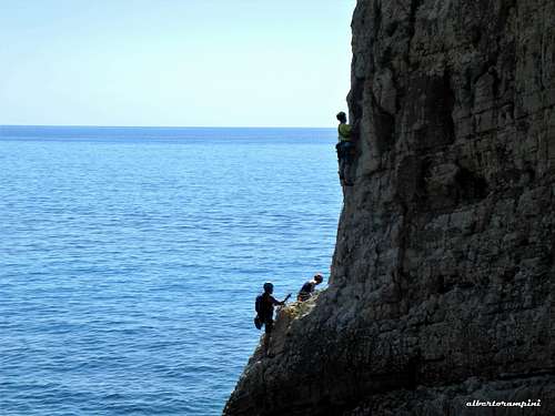
Main routes
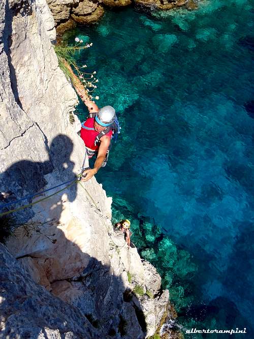
Pedra Longa presents, in addition to an old route in artificial climbing (Spigolo dell'Ospitalità) and a couple of low traverses covering the entire circumference of the monolith that are actually not frequented, two very recent routes opened in a modern perspective, which are very interesting and deserving.
On the North wall:
- Marinaio di Foresta 6a+ max, 190 m.
- Signorina Fantasia 5c max, 90 m
The Normal way of ascent on the NW side, certainly already traveled by locals in ancient times, is an easy route allowing to climb to the tip of the spire and used as the descent route, II degree, 90 m
- See here the topos of the North wall routes and the Normal route: Marinaio di foresta - 27crags Pedra Longa North wall routes - Planetmountain
There are also several equipped single pitches in the northern wall next to and on the right of the two routes mentioned above and others next to the access ladders.
On the South wall:
- Cronosomi corsari 6b+ max, 175 m See here the topo: Cromosomi Corsari - Pietra di Luna
Red Tape
No particular restrictions in hiking and climbing inside this area; from August 2016 a fee has been imposed to walk on the path to Cala Goloritzè (6 euros). Cars must be parked with care, only in the camping area and in any case without encumbering the existing shepherds' roads.
The Baunei area is lying inside Parco Nazionale del Gennargentu e del Golfo di Orosei. The wild territory of the park belongs to the Nuoro, Ogliastra and Cagliari provinces and had been established in 1998. Its 73.935 hectares' extension includes 18 communes: Aritzo (NU), Arzana (OG), Baunei (OG), Belvi (NU), Desulo (NU), Dorgali (NU), Fonni (NU), Gadoni (NU), Gairo (OG), Oliena (NU), Orgosolo (NU), Seui (OG), Seulo (CA), Talana (OG), Tonara (NU), Urzulei (OG), Ussassai (OG), Villagrande Strisaili (OG).
Climate
The climate is typically Mediterranean; plenty of sunshine, mild temperatures, poor rainfalls and windy weather. Some rainfalls usually occur from October to March and sometimes they may be violent, but generally brief. The mild climate of the island allows the climb all around the year, though South faces are always too hot in summer. Sometimes the NW wind (maestrale) may be a problem, when it’s very strong.
When to Climb
It’s possible to climb all around the year, but the best seasons are spring and fall.
Accomodation
- B&B, apartments and hotels in Baunei, S. Maria Navarrese, Cala Gonone and Dorgali
- Camping in Cala Gonone
Meteo
Guidebooks and maps

- Pietra di Luna - Trad & Multipitches Maurizio Oviglia Trad and sport multipitch guidebook - V updated edition Fabula 2015
- Sardegna Maurizio Oviglia Guida dei Monti d'Italia Club Alpino Italiano - Touring Club Italiano 1997