
|
|
Mountain/Rock |
|---|---|
|
|
27.80280°N / 88.11330°E |
|
|
Hiking, Mountaineering |
|
|
Spring, Fall |
|
|
19520 ft / 5950 m |
|
|
Overview
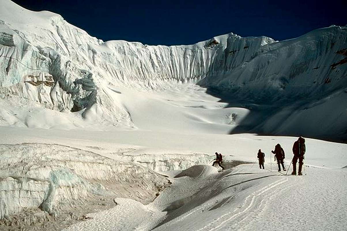
Glacier travel enroute to Peak 5950, which is off the left side of the photo
To call Peak 5950 a "peak" by Himalayan standards is stretching the definition. It is an unnamed high point on one arm of a complex ridge system. Higher points, on longer arms of the ridge look down on it. The entire system is dwarfed by one of the most magnificent mountain vistas on earth: the north face of Kangchenjunga and its attendant satellite peaks. In the midst this grandeur Peak 5950 is barely worth a glance. So why post it on SP?
1) Our ascent involved one day of reconnaissance to establish the location of a high camp at the base of a small glacier, returning the following day to sleep there during a fierce Himalayan wind storm. The climb on the next day involved several hours of roped glacier travel and an ascent of 1000 feet on firm snow at angles of 50 degrees or more. The descent required several hundred feet of rappel before resuming the downclimb to base camp. This activity fits into the category of "basic mountaineering"
2) The peak requires no additional fees over and above the standard trekking permit required to be in the area in the first place. It's a free add-on that provides for a few days of exploratory mountaineering during what was basically a remote trek. So, it is offered up as an option to climb if you are in the neighborhood, and to suggest that there are many other peaks like this, fun and within the ability of most climbers, especially in more secluded trekking regions.
3) This page will serve as a useful vehicle in my ignoble quest for SP points and hits.
What's the elevation of Peak 5950?
This is not quite like asking "Who's buried in Grant's tomb?". The high point of our trek was Pangpema, the Kangchenjunga north base camp. A web search turns up elevations for Pangpema ranging from 5000 to 5300 meters (16,500-17,500 feet). Three of us had altimeters and reset them at Pangpema to 5000 meters, the elevation given on the trekking map we were using. Of course the three altimeters had different readings on the summit, but they were between 5900 and 6000 meters. I'll settle on 5-9-5-0, which has a nice ring to it, and is close enough to accurate.Getting There - The Kangchenjunga Trek

Peak 5950 is north of Kangchenjunga, and getting there and back requires a 3 to 4 week trek. The longer time would typically be spent visiting both the north and south sides of Kangchenjunga, crossing the 15,000 foot Mirgin La to link the two. When viewed on a map this route is shaped like a "V" with an "H" stacked on top of it, if you use your imagination,. Only the upper arms of the "H" require backtracking, so it is mostly a circular trek. I have been on five Nepal treks, and the far east with its gigantic ice peaks towering directly over deep lush green valleys is my favorite region, wet weather notwithstanding.
Most people begin by flying into the small airstrip of Suketar, near the village of Taplejung. If you have some extra days and happen to enjoy hot, low elevation trekking then you can start from the road head in the Arun Valley. It is now possible to fly directly to Suketar from Kathmandu. When I was there in 1998 you were forced to spend a night in the stifling heat of Biratnigar, a town on the border with India. Fortunately our hotel was well stocked with Kingfisher beer since we spent two nights drinking there. Our first attempt to land at Suketar was aborted in the final minutes as clouds obscured the air strip, which is improbably perched on the crest of a steep, narrow ridge. The infamous landing at Lukla near Mount Everest has nothing over Suketar for adrenaline.
Our itinerary took us first to south side of Kangchenjunga. From Taplejung the route heads northeast, initially following a series of ridge crests. The trekking here is at an elevation of roughly 7,000 feet, and passes through villages, cultivated land, and mixed forest. In clear weather there are views of the astonishing snow peaks to the north. At Yamphudin, on day 3, you show your trekking permits for entry into the Kangchenjunga Conservation Area.
On day 5 you cross the 11,200' Lamite Bhanjang pass, villages are left behind and the trail drops into the Simbua Khola valley, the river that drains the southern slopes of Kangchenjunga. The trekking is now through lush forest, filled with orchids, moss, rhododendron, and leeches, which can be fierce during the post-monsoon season. One member of our group discovered a leech in his mouth after returning from a midnight nature call. No one knows, or wants to know, exactly how that happened. Three more days of ascending hiking brings you to the camp at Ramche (14,400' / 4390 m), alongside the lateral moraine of the Yalung Glacier. The crystal peaks of Kabru and Rathong dominate the scene. From here a day hike farther up the glacier provides fantastic views of Kangchenjunga south face, site of the first ascent.
From Ramche you retrace your steps downstream for a few hours (the right arm of the "H"), then turn north to cross the Mirgin La (the crossbar of the "H"), a series of 15'000' passes on the western spur of the Kangchenjunga massif. A more difficult option is the Lapsang La, a 16,500' pass east of the Mirgin. However, guidebook author Steve Razetti was staying at our hotel in Kathmandu, and said he prefers the more scenic Mirgin. The crossing takes two days, requiring a camp between the high points. Our passage took place mostly in cloud, but what views we had were breathtaking.
The descent off the Mirgin drops into the Tamur valley, and to the small Sherpa village of Ghunsa, the largest settlement in the region. British mountaineer Doug Scott had just passed through, en route to climbing Dhroma, a 6800 meter peak close to Peak 5950. A large British medical group was also in town. They had consumed all the beer in the village, but I hold no grudge.
From Ghunsa to Pangpema it is a three day trek, steadily climbing through beautiful larch forests, along glacial moraines, and past utterly magnificent peaks such as Jannu and Kambachen. Pangpema camp sits above the rubble of the Kangchenjunga Glacier, directly beneath aptly named Wedge Peak. The views of the north face of Kangchenjunga are the sort of thing everyone should see once in their life..
The return to Suketar airport takes five to six days, and past Ghunsa you continue down the Tamur River valley, now on the left leg of the "V", without retracing more steps. As noted above this is a nice, mostly circular route.
See the Northern Slopes route page for a description of our ascent of Peak 5950.
 |  |  |
When To Climb
The standard Himalayan high-elevation trekking season is either pre-monsoon (March - May) or post-monsoon (late September - November). Note that the eastern Himalaya receives the full force of the monsoon, often arriving early and leaving late. With that in mind it might be best to complete a pre-monsoon trip by early May, and to not begin a post-monsoon one until mid October.That said, this is the Himalaya and to some extent it's the luck of the draw. Severe storms dumping large amounts of snow can occur at any time. Passes may close, avalanche danger becomes considerable, and wind blowing like a jet. It's even possible that the weather will be nice!
As usual with any excursion to high altitude proper acclimatization is key to a safe and successful climb. In our case spending the time trekking to the south base camp first was an excellent way to get acclimatized for our later climb.
Red Tape
A visa is required to enter Nepal. As of May 2005 sixty-day visas cost USD $30 and can be purchased upon arrival, or at Royal Nepalese diplomatic missions abroad. Trekking fees for the Kangchenjunga region are USD $10 per week per person for the first week, and USD $20 per week thereafter. Trekking there must be done through a registered agency, so that cost will typically be bundled in the price of your trip.Here are two pages with useful information and further details on the regulations:
Travel-Nepal.com
Nepal Home Page.com
Sahibs, Sherpas, and Porters
It's good to reflect that we trekking sahibs and memsahibs could not have our memorable holidays without Sherpa and porter support. Much has been written about the goodwill and strength of these hardy mountain folk. I can only add that those accounts are generally accurate and inevitably we return with wonderful memories of our time spent with them.The Sherpas run the day to day logistics of the trek, choosing routes, organizing the porters, establishing camps, and often doing the cooking. They are simply the best at what they do, and great fun to be around. The cook crew will be up before dawn gathering water and preparing breakfast. They pass you on the trail and have lunch ready when you arrive, repeating the procedure for dinner. Porters carry huge loads, often singing along the way, so the sahibs can hike in comfort with a day pack. Chose a trekking agency that ensures the porters are properly treated and equipped.
It is fascinating to watch the porters move gracefully under their heavy loads, and compare that to the manner of many trekkers. Porters look for the trail within the trail, the precise track requiring the smallest amount of effort. They move in a steady, controlled fashion, and will take more smaller steps, rather than fewer large steps. Once you try this (something that did not come natural to me), you quickly see the benefit.
Sherpas will elect to take a break before tackling a difficult section of the trail. Trekkers, on the other hand, usually like to get the hard part over with, and then rest. But if you think about it, which way makes the most sense? I found that I had a lot to learn from our staff.
If you learn a few dozen words of Nepali it will further enhance the relationship. Learning to sing some Nepali folk songs like Resham Firiri or Pannko Paat is also great fun. One has to be a bit careful with the language, however. I was puzzled why the fact that I was from Colorado caused so much snickering, until I learned that kalo lado means black penis.
 |  |
High Elevation Hiking
I don't claim to be anything of an expert on this subject. There are many SP'ers who are far more knowledgeable than me, but if I add up the time over various trips I have spent at least six weeks above 15,000 feet. In general I have done quite well, while younger and stronger people have collapsed around me. I've seen High Altitude Pulmonary Edema (HAPE) and Cerebral Edema (HACE). They are not pretty. I was on a trip where someone died, it can and does happen. It could have been any of us.You put a lot of time, money, and effort into a big trip. You want it to be a pleasant memory. So, I'll offer up what has worked for me, and anyone who has an addition or correction please post it.
First and foremost is proper acclimatization. This process takes time and can't be rushed. Don't try to cut a few days off a major trip to save some small amount of time or money. You can be setting yourself up for a miserable holiday, or worse. Proper acclimatization means ascend slowly, no more than 1000-1500 feet per day above 12,000 feet. Also, if possible climb higher during the day but descend to a lower altitude for sleeping.
Stay hydrated! That bears repeating: stay hydrated, even if this means a couple of wake up calls during the night.
Be conscious of moving at a steady and controlled pace. Don't overexert to the point where recovery is difficult. Establish a rhythm between your steps and breathing. Don't rush. In Nepali it's bistari jaane, in Swahili pole pole. It means go slowly and it's wise advice. On one of my trips a very fit guy was always first into camp, blazing trail well beyond everyone else. He did fine for a couple of weeks but at the end of week 3, when we were crossing a 19,000' pass, he had burned himself out. He struggled to get up the thing, while for me it was one of the most enjoyable days of the trip. He never recovered during the last week, even when we dropped below 14,000' and the rest of us felt like supermen. Take it easy.
Pay attention to early signs of AMS. The most typical are a throbbing headache, followed by nausea and vomiting, Tell other people in your group if you are experiencing this. If you have these symptoms for more than a day then stop going up. The progression from acute but not life-threatening AMS to severe HACE or HAPE can happen in a matter of hours. Death can follow hours later. If you are having problems don't think you'll get over it by pushing on. This can be hard to do when you are far from home and have spent a lot of money, but it must be done sometimes..
Everyone has a religious opinion about taking drugs like Diamox. I used Diamox on one trip and perhaps it helped, hard to say. It may be that I slept better (when I didn't have to pee from taking it), or it may be that I was just acclimatizing. Some people swear by it and others curse it. Personally I would always have it on a trip just in case it came in handy, but plan and hope that proper acclimatization does the trick.
I have also used Gingko Biloba, had no ill effects, and believe that it might have helped.
Check out the altitude page at the CIWEC Clinc site for more information.
Altitude sickness is scary. It strikes with unpredictable ferocity. But following some simple and well established rules will increase your odds of avoiding it. You may even feel good enough to get that hard-to-define euphoria, when feeling healthy in a supreme setting on the roof of the world.
 |