
-
 5217 Hits
-
 73.06% Score
-
 3 Votes
|
|
Route |
|---|---|
|
|
46.26650°N / 13.66270°E |
|
|
Mountaineering, Scrambling |
|
|
Summer, Fall |
|
|
One to two days |
|
|
Class 3 |
|
|
scramble, mountaineering experience needed |
|
|
Approach
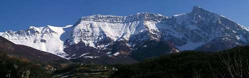
Krnčica ridge and Krn from the West
From Kobarid town in Soča valley you drive up to Drežnica village (554 m), through it and by a narrow mountain road towards the north through Drežniške Ravne on the alpine meadows Zapleč and Zaprikraj (1200 m).
The character
This is a 12-14 hours scramble. Because of interesting remnants of the World War 1, you will probably need some more time to explore. This is certainly one of the most beautiful approaches to Krn. Panoramic, lonesome (you will even in summer hardly meet anyone) and it gives you a scent of adventure too. Be careful at orientation and on a steep terrain!
Show a bigger map
Route Description
After "enjoying" a bad road so long time we joyfully pack heavy rucksacks with all bivouac equipment. As there are many caverns from the World War I, we don't need tents. The first 750 meters of altitude to Velika Vrata pass (1938 m) are quite tiresome (marked path). There we hide our equipment.
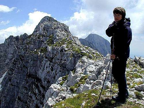
The ascent on Krnčica (2142 m) is technically not demanding. It is best to scramble directly by the ridge, if this one becomes too narrow we can always look for the old military paths, climbing on the right (western) side, just below the ridge. From the summit we have a great view.
Also the continuation by the ridge is only a medium hard scramble. It is best to go by the top of it, but interesting remnants of WW1 often attract our attention to deflect a bit. It seems that we shall this way reach Krn itself, but the last part of the ridge is a hard climb. So just below the summit rocks of Krn we descend from the ridge to the left on broad karstic plateau and traverse below the northern slopes of Krn to Krnska škrbina (notch), 2058 m.
From the notch we can ascend Krn (to the right) but it is also a valuable goal to ascend the nearby Batognica (2164 m), which is on the left.
On return, we go the same route to the foothills of Krnčica ridge (where we descended from it previously). On the eastern side, some 50 meters below it, we must now find an old military path, going all along the ridge. This is one of the most interesting parts of the tour. Old walls, positions, caves, everything still quite preserved. In this wilderness, we can not miss, all the time we go northwards. After passing the summit of Krnčica, it is worth visiting also the summit of Griva.
There are remains of a whole military village. These positions were Italian, Austro-Hungarian positions were just some 50 meters below, but through no-one's land also no path goes. Returning below the summit of Krnčica it is worth to continue also to the summit of Skutnik. We use military paths again, but the top few meters are steep and exposed. On return we cross the Krnica basin and ascend to Vrata pass where our equipment waits.
If we have enough for today, we can arrange now a comfortable bivouac in one of the nearby military caverns or under the blue sky, of course. Next day the long part of the NW ridge beyond Vrata pass awaits for us. This is a panoramic hike, partly going by the ridge itself, partly left below it. We use all the time military paths. The last distinctive summit of the ridge is Kal. Here were also Italian positions, but just some 20 meters in the rocks below, there were already Austrians. Also here Austrians were digging tunnels to blow up Italians, holding the summit. On Kal you just look back to the whole long NW ridge, then you can start to descend. Return a little by the ridge and find a military supply path, going down to alpine meadows.
Essential Gear
Sleeping bag, food and enough water, poles, good shoes. In case of bad visibility either stay at home or at least take a good compass.