Old Goats Scramble North Twin Sister

Old Goats Scramble North Twin Sister

Page Type Page Type: Trip Report
Location Lat/Lon: 48.71537°N / 121.99843°W
Date Date Climbed/Hiked: Jun 3, 2007
Activities Activities: Mountaineering, Scrambling, Skiing
Seasons Season: Spring, Summer, Fall

North Twin Sister West Ridge Trip Report:


North Twin Sister North Twin Sister; west ridge on the right skyline

On impulse I looked down and there before me on bended knee were 200 ravishing, gorgeous females!

No sorry, that’s wrong. I meant ravenous and gorging.

The bent knees were mine and the females were of the blood-sucking gender of the genus Anopheles clustered thickly on each kneecap where the fabric of my pants was stretched tightest and thinnest thus enabling the easiest route to their supper. But, hey, at my age, you take female attention where you can get it right?

This all took place at a camp that Don (74), Tony (65) and I, Martin (the baby at 60) had placed at the top of the highest road giving access to the west ridge of North Twin Sister, our objective for the following morning.

We had left Victoria, BC on the 9 am ferry earlier that day, had endured the now normal but fortunately brief encounter with US border paranoia and arrived at the gated bridge over the Nooksack Middle Fork at exactly 1.10 pm. Judging by the number and type of vehicles parked there, there were obviously quite a few people making the more usual bike-approach day-trip out of the climb than planning an overnighter. None of us creakier types much fancied pushing heavy bikes up 850 vertical metres of logging road, so we had opted to haul even heavier packs up there instead. I’m still not sure if this was the right decision and it’s too late now anyway.

For the most part the roads are in very good shape and all you have to do is put your head down, your brain in neutral and grunt away steadily for 4 hours or so. The only distraction of note that I can remember was fording the Galbraith River at 3.30 and at an elevation of 880 metres. The approach directions Tony had printed out from Matt Gunn’s “Scrambles in Southwest British Columbia” (I love the way Matt has annexed Washington) were impeccable and without putting a foot wrong, 5.30 pm saw us at the bottom of the trail that leads through recent new growth, nice open old growth and finally onto the west ridge itself. The afternoon had been clear and hot and after pitching camp all we really wanted to do was drink, drink and drink some more. Having re-hydrated we finally did feel more like supper and eventually got round to fueling up for the next day’s effort.

Camp at the Base of the West Ridge.
Mosquito heaven below North Twin

If anyone is planning on camping at this spot note that unless there’s snow on the ground the nearest water is 5 minutes back down the road you came up on at the last switchback that turns right. Fill up here before carrying on to camp where we did. Or, for the sake of 5 minutes, put your tent up right by the road. There’s no-one coming this way but folk mountain biking down the road and they’re all long gone by 6 pm or so.

By 8 pm we’d eaten, cleared away, organised packs for the morning, fed the dense clouds of mosquitoes many times over and were pretty well driven into the blessed relief of the tents by 8.30. The night was warm and I didn’t even get into my sleeping bag until the early hours of the following morning.

As usual before a climb, I slept fitfully and was already up when my alarm went off at 5 am the next day. After the usual morning ablutions and oblations to the local mountain gods – and giving the mozzies their breakfast of course - we were off up the trail in smart order at 6.10 am.
 
West Ridge in Profile
Base of the west ridge
 
Don Scrambling the Lower West Ridge
Lower west ridge.

It takes only about 45 minutes of easy walking before the ridge narrows, the first easy scrambling starts and its time to put the pole away and the helmet on.

The route goes very gently at first at barely Class 2 but then Class 3 passages begin to present themselves more frequently and of longer duration. By the time the “obelisk” was reached at about 8 am, the ridge is solid Class 3 climbing and you’re beginning to wonder if that last 20 metres or so wouldn’t have been more accurately described as easy 4th. Eschewing MountaingirlBC’s and others’ heroics on the obelisk as the domain of those who have not yet discovered the meaning of mortality, we down-climbed a little to the right and made progress up towards the false summit mostly on this side of the ridge crest. 

Middle Ground on the West Ridge
West ridge above the obelisk

A few false leads followed to be sure but, as all the books say, the olivine rock makes you feel like Spiderman and a huge hold presents itself almost every time you need one. I can only remember once stepping up to find I had to use a crimper for my next handhold rather than a huge velcro jug. Not bad at all in 800 metres of vertical gain.

Once the base of the false summit was reached we down-climbed a bit to the right – following Becky’s route now rather than Gunn’s - until we could see the “comb” above us on the skyline. This a distinctive set of rooster’s comb-like pinnacles on the ridgeline approximately midway between the false and main summits. We then traversed to the right to a chossy gully directly below an obvious notch in the ridge to climber’s right of the comb. Rather than the gully we went up Class 4 slabs and blocky faces to its left and arrived in the target notch little more ten minutes later.
Upper West Ridge
Upper west ridge approaching the notch

From the notch we squeezed through a narrow cleft that gave easy access to the ridge once again, walked across a flat snowfield and then up to a small sub-summit from which the main summit was in full view. 

View from the Snow Saddle
The snow saddle just below the summit.

From this point it was only a matter of walking down a gentle snow slope to the narrow snow saddle above the north face and a further minute of easy Class 3 to the top of North Twin. We summited at 10.55 precisely.

Approaching the Summit
Approaching the summit of North Twin

Now began the summit photo ritual. The only problem is that there’s barely room for 3 people up there and stepping back sufficiently to get subject plus Baker or South Twin in shot results in becoming gravitationally challenged in short order, followed quite soon thereafter by death. So we made do with close ups of two days of stubble and maybe-that’s-Baker-peeping-over-his-shoulder stuff before returning to the snow saddle at the top of the north face for real photos and lunch.

South Twin from the Summit of North Twin Sister South Twin from the summit of North Twin
Mt Baker Mt Baker from the summit of North Twin

It’s hard to wax eloquent enough about the views, at least on the day we climbed North Twin. Perhaps it was a little too hot to deliver the right clarity for that perfect photo but who cares. It felt like you could almost reach out and touch Baker and in spite of the haze, we could still see as far as Rainier.
The North Face
Contemplating the descent.
Downclimbing the North Face
Downclimbing the north face

The north face is steep. We set off down it at 10 minute intervals at about 11.30. Tony first, then Don, and then me. We all faced in for at least the first 150 vertical metres. Judging by the angle of my axe relative to the snow, I would estimate the slope to be at least 60° and maybe even more right where you drop off the saddle. Take this bit seriously! Don’t start to glissade too soon – or at all. I did and, to my shame, lost control. All ended well but let me just say thanks to “Dave” in the group that followed us down and retrieved the bits that fell off!

NW Face
Traversing back under the NW face

Once the initial steep bit was behind us the return to camp became a pleasant walk traversing under the NW face to intersect the west ridge just before the point where we had put the poles away that morning.

We arrived back at the tents at 2.15, a quick brew, pack up (why is one’s pack always heavier and fuller on the way out?) and we were heading down about 3.15. Just over two and a half hours of I-don’t-think-my-knees-were-made-to-do-this later and the Nooksack hove once more into view.
The Long Road Home
The long road home.

Thanks to my patented (and highly secret) border approach methodology, we negotiated a more than half-mile long traffic queue at Customs in just under 15 minutes and made the 9 pm sailing with ease. We got our $17 worth out of BC Ferries “Pacific Buffet” that night I can tell you.

A few notes about gear. We carried a rope and some rock pro but never got anything out of the packs. We also schlepped crampons and a couple of pickets up to our camp but, based on the reports of people coming down and the temperatures during the night, left all that at the tents. Axes, however, were essential to downclimb the north face. Work gloves for the west ridge save cuts and scrapes on the super abrasive rock and make the climb that much more pleasant.

Many thanks to Don and Tony. Great companions both and a privilege to share this experience with. Thanks a million guys!

Page Visitor Statistics

free counters


Comments

Post a Comment
Viewing: 1-17 of 17
Norman

Norman - Jun 6, 2007 11:52 pm - Voted 10/10

N Twin

Hey...Very nice report! I live in Ferndale, WA. We've been up there a few times. We can see it any day its clear too and always makes me want to do some climbing, just seeing it. Congradulations.

vancouver islander

vancouver islander - Jun 7, 2007 2:10 am - Hasn't voted

Re: N Twin

Ah Ferndale - home of the last Super8 before the border when we've missed the last ferry.

Thanks Norm. It was a great route and, boringly arduous as the approach was, it made a nice change from an Island bushwhack.

Logging roads??? Good grief, they'd pass for freeways in BC.

Norman

Norman - Jun 7, 2007 12:28 pm - Voted 10/10

N Twin

V Islander:
Like I said, we were up there last Fall, trying for the South Twin (did not make it). What was a surprise is the road access now form the North Fork Nooksack road that the Olivine Mine uses, now the branch off toward the old logging roads was open. Looks like something else is planned??? for the area??? Have you been up there before this climb and notice access difference? Anyway, again, I enjoyed your report.

Sonnik

Sonnik - Jun 11, 2007 7:58 am - Voted 10/10

top report

Great job on the climb and bloody well written too.

Also glad to hear of your upholding the proper decorum of "ablutions and oblations to the local mountain gods".

vancouver islander

vancouver islander - Jun 11, 2007 11:52 am - Hasn't voted

Re: top report

G'day Sonnik and many thanks. Always nice to see one's efforts appreciated.

gimpilator

gimpilator - Jun 11, 2007 11:42 am - Voted 10/10

Sweet Report!

We were up there a couple weeks ago and luckily the ravenous females weren't in full force yet. Also I've found that sometimes unintentional glissades can be more fun/exciting than the planned ones.

vancouver islander

vancouver islander - Jun 11, 2007 11:55 am - Hasn't voted

Re: Sweet Report!

Many thanks.

Over a week on and my bites are still itching. I swear they were going right through the deet!

Didn't detract from a great trip though.

klwagar

klwagar - Jun 11, 2007 11:25 pm - Voted 10/10

Cool report

One of those routes I would like to do sometime.

vancouver islander

vancouver islander - Jun 12, 2007 12:03 am - Hasn't voted

Re: Cool report

Thanks mate - and for the kind vote too.

Highly recommended climb. Maybe go a bit earlier to avoid the mozzies. Or maybe in Sept once the first frosts have killed a few of them off. Not that they're that much of a problem and none at all once you're on the ridge proper.

Little_Mole

Little_Mole - Jun 12, 2007 6:52 am - Voted 10/10

Brilliant!

What a brilliant report!! You really have a talent to tell stories! Ever thought of writing for money?
Anyway, I wish I could go with you the next time. It seems to be a really good time. Go on!
Cheers, Ulrich

vancouver islander

vancouver islander - Jun 12, 2007 11:31 am - Hasn't voted

Re: Brilliant!

Ulrich, what kind and generous comments. Thank you.

As might be obvious, I enjoy writing. However, I think doing it for money would spoil the fun. I do it mostly for friends and family.

Thanks once more.

Cheers,

Martin

Ps If you enjoyed this story try those I wrote on "Around the Houses to Everest" or my Elkhorn TR

mvs

mvs - Aug 11, 2007 4:04 pm - Voted 10/10

nice tr :D

"Eschewing MountaingirlBC’s and others’ heroics on the obelisk as the domain of those who have not yet discovered the meaning of mortality,..."

HAHA!

Schlepping the bike up is worth it though, because the ride down does a lot to erase the memory of the wearisome roads. Also, I think managing to find the trailhead without getting lost on those roads is a bigger accomplishment than reaching the summit...well done! :-P. Thanks for your nice TR which brought back memories of the area for me too.

vancouver islander

vancouver islander - Aug 11, 2007 4:56 pm - Hasn't voted

Re: nice tr :D

Many thanks. I've enjoyed reading about your daring-do exploits in Europe too.

The roads are probably easier to navigate than they were. Matt Gunn's guide (linked in the TR) was spot on every step of the way. Not difficult at all. For me the crux was downclimbing the north face. I can't believe that some bum-slide right off the top! But they do.

Keep those European TR's coming.

Cheers,

Martin

DrJonnie

DrJonnie - Jan 20, 2008 6:08 pm - Voted 10/10

Parasites

I used to think that the midges in Scotland were bad but it sounds like your friendly insects are worse. Our one advantage is that the midges don't like wind, any sort of a breeze and they are grounded. I've had some bad experiences with the midges on Skye but luckily once away from the campsite on the hills they disapear.
cheers Johnnie

vancouver islander

vancouver islander - Jan 20, 2008 6:31 pm - Hasn't voted

Re: Parasites

Hi Dr J. I've had plenty of experience with midges on Skye is my youth. Thought they were bad until until I broadened my horizons. Our mozzies make midges seem benign. It's quite routine on Vancouver Island to hike/climb with a mesh headnet on your cap/helmet ready to pull down as soon as you stop moving.

Even worse are the leeches of Nepal, Australia etc and the worst of the lot, in my experience, are the sandflies of New Zealand.

DrJonnie

DrJonnie - Jan 21, 2008 5:37 am - Voted 10/10

Parasites

Hi there,
my daughter is into parasitology and is always warning me about west nile, lymes disease and not to forget malaria. I hope you managed to escape all these in your brushes with those nasty beasties.

The last time I went to Skye, I took a mosquito net that I bought for a trip to Brasil but it was no barrier, the fiendish mozzies waltzed straight thro' it.

cheers Johnnie

PeakBeggar

PeakBeggar - Sep 3, 2010 1:46 pm - Hasn't voted
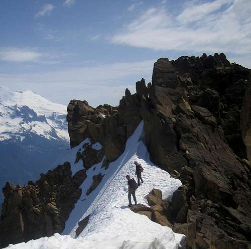
Sweet!

Nice TR, I am planning on making an attempt on north twin before the season is out and your pictures are great for seeing the terrain that'll be encountered

Viewing: 1-17 of 17

Parents 

Parents

Parents refers to a larger category under which an object falls. For example, theAconcagua mountain page has the 'Aconcagua Group' and the 'Seven Summits' asparents and is a parent itself to many routes, photos, and Trip Reports.

North TwinTrip Reports