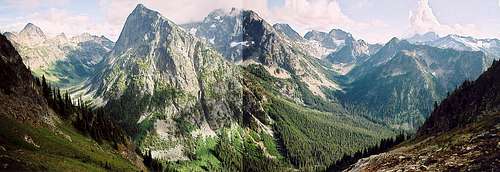
Ragged-Red Traverse, Aug. 11-13, 2006
Stefan informed me at the beginning of this outing that he had landfilled his old shorts with the ripped back side. I was giddy with glee, no more unwanted views of…
Anyway, Stefan Feller and I finally accomplished the Ragged Ridge-Red Mountain Traverse. We had both wanted to do the traverse at some point in our lives. It had been done before but possibly not for a while so it wasn’t as if we were breaking new ground. Note that we did not do an “enchainment.”
Ragged Ridge and the long ridge of Red Mountain form one long divide some 13 miles in length running roughly east to west but with the western end bending northwestward to Fourth of July Pass. The east end begins at Easy Pass or just northwest of it at the first significant peak on the divide: Kitling Peak (8,002 ft). The eastern six miles of divide is Ragged Ridge (so-named on the map). This ridge features four Washington Top 100 peaks and numerous sub-summits. The Top 100 summits are, in east-to-west
and highest-to-lowest order,
Panther Peak (aka Mesahchie Peak), Mt. Holyoke (aka Katsuk Peak), Gendarmes Peak (aka Kimtah Peak), and
Ragged End (aka Cosho Peak). The parenthetical names are the “official” ones (because they’re on the map) but they are not the “correct” ones. The “official” ones were introduced by one Mr. Fred Beckey even though he’s never been there. His names derive from the Chinook jargon. Mesahchie means “wicked”; Katsuk means “center”, Kimtah means “behind, after, last”, and Cosho means “pig” or “salted pork.” Kind of stupid names, yes? The “correct” names, though not perfect themselves, were mostly established by Dr. John Roper, who happens to have the first ascent of three of them—Holyoke (August 1968), Gendarmes (June 1970), and Ragged End (June 1970). Roper’s register for the latter still exists. Holyoke derives from his then-wife’s alma mater (he made the FA with her). Gendarmes derives from the character of the mountain, and Ragged End derives from the
consensus (see next paragraph) that it is the last significant mountain on Ragged Ridge.
The west end of Ragged Ridge connects seamlessly with the long ridge forming Red Mountain. The Red Mountain divide itself contains three significant high points:
Pk 7533 (413P), called “Pig Tail Peak” or “Pigheaded Peak”, one mile west of Ragged End;
Red Mountain’s highest point (7658F, 618P); and
Ragged BM (7598F, 238P). There are other lesser crags and sharper sections of crest that I will omit here. If one were to be a stickler for infinitely incidental details, one might argue that Pk 7533 belongs more to Ragged Ridge than Red Mountain since the lower divide (approx. 7,020 ft) is on the peak’s west. But, comparing to Ragged Ridge’s ragged nature, Pk 7533 is actually quite disarming—like a little red-haired girl in pigtails. I will mention that the peak is not red-colored at all but there is red rock between it and Ragged End.
Since I had been up the first two peaks on the agenda before, I left this part of the report for Stefan to write…
We went out and did the Ragged Ridge traverse this weekend from Easy Pass to Fourth of July Pass. Since Paul had already done Mesahchie and Katsuk, I will just give my personal synopsis on what happened on these two mountains....and then Paul will take over from there on his future trip report.
We left the car around 9:00 or 9:30 on Friday, August 11 under cloudy skies, which was a blessing but I was worried about precipitation--fortunately not a licking came out of the sky for this day. We made our way to Easy Pass and started the traverse. Brush was wet and this made my feet wet for two days thereby increasing my normal blistering for a standard trip. But, then again, I haven't been out for a while doing family things and my feet aren’t so tough anyway.
We made the basin below Mesahchie-Katsuk sometime around 2:00p.m and I took off in the foggy conditions first for Katsuk while Paul lazed at camp. I took the standard ridge up from Pt. 7430, hit the obvious wall everybody reaches, took a left around it, and up and up and up I went working the easiest of lines and finding cairns. My altimeter read 8500 feet at the ridgeline but fog obscured everything so I saw this one pinnacle and thought that was the summit. I scrambled to its top but did not find a register. Huh? Then the fog cleared almost immediately and I could see the twin summits of Katsuk well to the west. Disappointment. So I scrambled down and worked my way through ribs and gullies over to the real summit area, reaching the eastern summit first. The fog was beginning to dissipate--I could now see well into the north and east but south and west were obscured. I signed the register quickly and then went down and then over to tag the western summit (it looked like to be about the same height) without looking for a register and made my way back quickly. I traversed kind of high eastward towards the fake pinnacle I had earlier reached, dropped about 40 feet to a very nice ledge that cut across and above the slabs that Fay Pullen had mentioned in her trip report. These slabs had concerned me reading her report. My wide ledge with boulders (at about 8400 feet and below the second pinnacle west of the Katsuk-Mesahchie col) cut across the slabs with ease and only required about 15 feet of non-exposed moves on slab-like stuff. I DO NOT LIKE LOW DOWNSLOPING SLABS. I went down another slab-like section to reach the Katsuk-Mesahchie col, and then took the couloirs up to the Mesahchie’s summit. Nicer views this time but not to the west or south. I retraced my route across that great ledge and made it back to Paul in the basin. 5 hours from the basin to both summits and back.
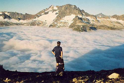
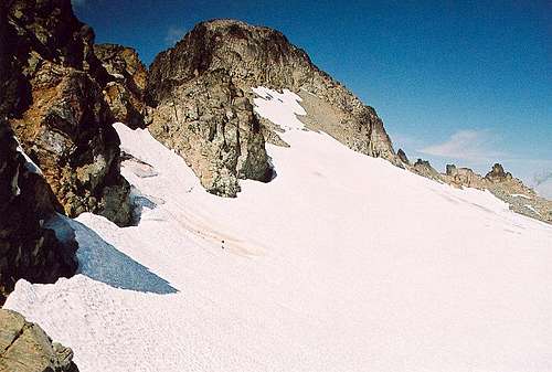
The views from camp were so lame I had to paint the scene for you
![]()
On Day 2 at around 6:00am we set out on the remainder of our traverse—the remainder being most of it. The weather had improved markedly. Now the only clouds were ones low in the valley and they were quick to disappear. I had left my car at the Panther Creek Trailhead as we weren’t going to come out the same way. We were over 16 miles from my car with only six of those miles to occur on anything resembling a trail. And even the trail part was not without exasperation. More on that later.
The views were still lame the next morning; more painting
![]()
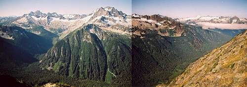
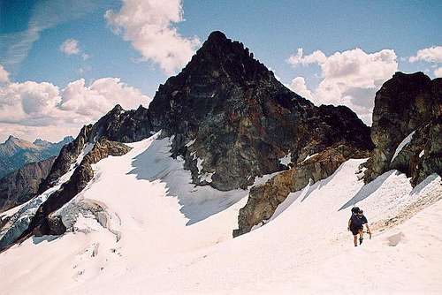
We climbed up to Pt. 7430, and commenced the long, lateral hike and scramble, making use of ledges where possible and climbing in and out of the many minor and not so minor canyons by the easiest routes we could find. There are various reports and guidebooks that speak of ledges between 7000 ft and 7400 ft. I would say we made use of the ones at 7400. Our pace was good. When we arrived at the south rib of the Grotesque Gendarmes (the oddly shaped pinnacles southeast of Gendarmes Peak) we found a way through by up-climbing maybe 60 feet of Class 3/4 to attain another ledge higher up. At no point were we stymied on our route selection but there were certainly times where we had to scout a little.
Tilted Grotesqueitude (was the world tipping or was it me?)
![]() Were the views ever going to get better? I had my doubts
Were the views ever going to get better? I had my doubts
![]()
I had brought along pictures from John Scurlock of our objective mountains. With
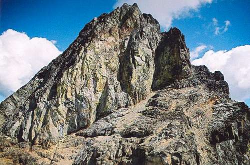
this photo of Gendarmes we could ascertain which ledge we were on during the approach under the mountain’s south face. We were on the ledge (snowed over in the photo) that comes in from near bottom-right. In about 3 hours, 45 minutes from camp we crossed the mouth of the large gully that empties the open upper west side of the south face. We proceeded around the corner of the large capital-A shaped buttress, dropped our packs, and made the final scramble to the top, reaching it in just over four hours. The
summit tower looked like Class 4 from a distance but turned out to be Class 3. The summit was cozy—
especially for the moon beamer.
One ragged gendarme this is; third-highest rag on this ragged ridge
![]() Views from this high rag; what’s the point of climbing it if this is all you get?
Views from this high rag; what’s the point of climbing it if this is all you get?
![]()
![]()
![]()
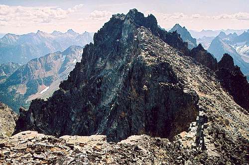
Our next objective was just to the west: Ragged End. From the western promontory sub-summit of Gendarmes I could see most of the route to Ragged End. From our packs, we continued on the ledge nearly to its end whereupon we jogged upward on easy rock to get to the col between the peaks. Crossing here onto the upper reaches of the glacier, we booted up semi-firm firn to the final east ridge. Stefan put his crampons on only because he had brought them. We both got out our ice axes though they too weren’t really necessary. There is only really one steep part for 40 linear feet and there is always a good run out with no crevasses whatsoever. The only concern might have been exposed ice.
The end of the rag tops
![]() The rag top we had just topped
The rag top we had just topped
![]()
From the east ridge I went out on the middle of the three horizontal ledges visible on the upper south face in
this Scurlock photo of Ragged End in an attempt to reach the spiral ramp that leads down to the mountain’s western base. Once at that ramp we’d drop packs and jaunt to the summit. Well, the middle ledge deadended in an alcove where it narrowed then disappeared into a thin horizontal crack in the far rib wall. Of course, on the other side of the rib the ledge continued but climbing out of the alcove required Class 5 and we had no rope nor guts. Fortunately, we had wasted very little time. I spotted the next-higher ledge and so we took that without incident to the spiral ramp. In another 10 minutes we were at the top enjoying our own private packages of Beddar Cheddar Johnsonville Brats.
More view suckdom; the blisters on Stefan’s feet might have been more pleasing to the eye
![]()
![]()
Back at the spiral ramp, we took it easily to the base of the formidable west face then out to begin the Red Mountain portion of the climb.
Ragged End’s ragged West Face
![]()
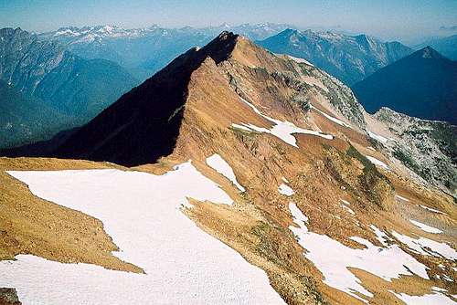
The first section of ridge out to Pk 7533 goes along a still-ragged edge. I kept smelling sulfur. Was it in the rocks? It was somewhat yellow in color. At one point we were forced slightly off the north side on a ledge bypassing a slanted crest slab. From above, this north side ledge looked flat but when we got onto it it was of the sloping variety with ball-bearing gravel all over it above a cliff. This was definitely the butt-pucker crux for the entire trip. The worst part was the fact that the better, half-a-tread wide footholds were at the base of the slabs just above the cliff. And these footholds were also covered in loose metamorphic peas. We really had to mind these peas and queue up the quality of our climbing expertise. Eventually we dispatched the ledge and got to safe ground where we could check our underwear for excrement.
We later applied the name Pigheaded Peak to Pk 7533. The story for this one is Beckey renamed Roper’s Ragged End to Cosho Peak and it is now Cosho that is on the map even though Beckey has never been there. As stated, “cosho” means pig or salted pork in the Chinook jargon. Maybe Beckey was referring to Roper with this priggish pig name (the two haven’t always seen eye to eye or oink to oink). But which one is the pighead? Later, Roper thought Pig Tail would be a good name since
Pk 6865 at the head of Panther Creek has the name “Panther Tail Peak.” This alternate name worked for me too—additionally so because I had seen my first mountain lion(s) in Bachelor Creek the weekend prior.
Pig Tail Peak from the east
![]() Ragged Ridge from Pig Tail
Ragged Ridge from Pig Tail
![]() Red Mountain from Pig Tail
Red Mountain from Pig Tail
![]()
In addition to the lame terrain, we were almost depleted of water so did our best to scan for running trickles coming off of the many small snow and ice patches on the north side of the divide. We saw what appeared to be a good source at a pool at the base of a large snow patch but opted to carry on to the next one. Finally below Pt. 7296 we found running water. It was about 100 vertical feet below the divide and was accessible with only Class 2/3 downclimbing. Just west of there in an idyllic spot with short grass and long views we set up Camp 2 at 5:00pm. I went down for water. Note: it is difficult to scramble up a chossy rock crease with one hand clutching a trekking pole and the other carrying a six-liter platypus bag whose top won’t close. But I only spilled a little bit and we’d still have more than enough for camp.
Except for the crescent moon very low on the horizon, an idyllic camp
![]()
That evening I got to see two moons: one in the sky and one somewhat more grounded. Please pull up your pants, Stefan!
The next morning we set out at 7:15 for what was supposed to be a leisurely ridge stroll. We estimated 4 hours to get to Fourth of July Pass then another 2.5 to get to my car down the Panther Creek Trail. But I think Stefan was pained by blains and the weight of 24 feet of duct tape wrapped around his toes.
We went over the top of Red Mountain first (no register), arriving there about 45 minutes after leaving camp. Man what a great viewpoint! The moon still slowly waltzed across the welkin but fortunately Stefan’s moon had set…but it would rise again later on!
Red Mountain on approach
![]() Ragged BM from Red Mountain
Ragged BM from Red Mountain
![]() Red Mountain on departure
Red Mountain on departure
![]()
The next target was Ragged BM 0.8 miles NW of Red Mountain. This summit has two benchmarks on it from 1968. One of them has the triangulating arrow on it pointing toward Mt. Logan. My guess is it points to
Soldier Boy BM.
Ragged BM on approach
![]()
The terrain after Ragged BM would eventually grow easier and more like parkland once we got past a few more steep sections of ridge. Stefan was uncertain if it was going to go but I said it would be better than traversing all those boulders in the northeast basin. To our happy feet and clocks, we only encountered Class 3.
The terminus of Red Mountain down to Fourth of July Pass
![]() Three more sucky views
Three more sucky views
![]()
![]()
![]()
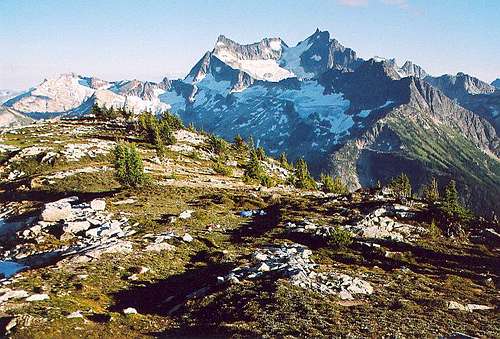
We could see over to
Jack Mountain quite well. Little did we know that friend
Martin Shetter would be finishing the
Bulger Top 100 List on Jack the same day. Congratulations, Martin! The 24th (23rd) to finish that list (see
here for more info).
The parkland eventually gave way to blueberries and brush. Ok, the blueberries
were the brush. I’m talking about the tall type of blueberry bush (huckleberries?). The ridge went on and on like this. It was this section that would make reversing this traverse much worse. At least we had the downhill momentum advantage, for the tall brush would typically genu-deflect to the side in deference to we peakbagger kings. But it went on and on just the same. At least the last mile or so was through open forest with slippery duff Stefan made the most to introduce his moon to. In six hours we plopped onto the trail.
Now we had only the Panther Creek Trail to descend…
Stefan had warned me about the lunacy of this trail. I couldn’t understand what he was getting at. I was to come to understand soon enough. But even now, writing this report, I still don’t really understand. Whoever was in charge of building the Panther Creek Trail must have had too little plumber’s ass for the job.
The Panther Creek Trail starts out well on descent from the 3,600-ft pass. In about an hour we made it to the creek crossing at 2,400 ft. A new bridge is there but it inexplicably has no stairs on the down-trail side. This means you’ve got to do a Class 3 stem move to a huge boulder or move around the outside of the handrail to step down to a pedestal stair. After the creek the trail traverses under a fantastic wall some 100 feet high that looks ripe for top-roped rock climbing. It is smooth and features nubs and tiny ledges for holds. But the moss is a bit on the heavy side right now. About a mile down-trail from the crossing the trail begins to climb (at 2,200 ft), less than a mile as the crow flies from the car. At first it appears it is only climbing to avoid a nearby cliffy area by the creek. But this is not the case. Before long I’m sweating up a storm on my skin and inside my head as I turn about at switchback after switchback. 30 minutes and 800 vertical feet later the trail tops out just before I blow my top. What in the hell have I been climbing for…in the opposite direction to the car, no less? Almost immediately, the trail begins to lose that 800 feet back in what seems like only 300 yards or so from where I was just ascending it. I just don’t understand. So I sent an email to the head ranger of the park. She didn’t know exactly why the trail does as it does either but she agreed it is an oddity. After 3 hours on the trail (probably a half-hour longer than I needed to be) I was certainly exasperated. So I aspirated my Tecate to make myself feel better. Oh, and the bag of chips too.
On the negative side
We didn’t get any good views on this climb. The North Cascades have no views.
Why did they make it a national park, again?
On the positive side
In 3 days of climbing over 22 miles we saw only 2 people and this was within the first half-mile of the Easy Pass Trailhead. Ah, the way all mountaineering experiences should be! Maybe the Panther Creek Trail does have one redeeming value. But, oh, did I tell you about the brushy section draped with stinging nettles?
On the trivial side
This outing satisfied my continuing quest to climb every Red Mountain in Washington State, of which there are nine. I am only speaking of peaks with this exact name, not ones which use Red Mountain as an alternate name, such as Painted Mountain southwest of Glacier Peak or Mount Larrabee. I have three Reds left:
one in Benton County (1410F, 720P),
one in Snohomish County (5720+F, 1440P), and
one in King County (5447F, 727P). {Addendum: as of Memorial Day, 2007 the Benton County Red (sounds like a wine and, in fact, there is a Red Mountain Winery) has been climbed. It was anticlimactic. So now I have only two left.}
Stefan's Epilogue:
Are you a peakbagger? If you are, then there is a peak open to you on Logger's Island: Rinker Ridge (3760+F, 1360P).
A road goes to very near the top. Your car may get scratched a little; high-clearance required. The actual summit is through some trees very near the highest road. No views. The road leaves from Finney Creek Road on the north. The gate there is (currently) open! Do not follow the USGS map because it is outdated. You need a Green Trails map for the correct roads.
My epilogue:
Please pull up your pants, Stefan!


Comments
Post a Comment