Ecuador
A few years ago, I started thinking seriously about mountaineering in South America. I had already heard about the
Avenue of the Volcanos in Ecuador, and I thought this Avenue was right up my alley.
![Cotopaxi, seen from the approach to the Ilinizas]() Cotopaxi from the approach to the Ilinizas
Cotopaxi from the approach to the Ilinizas
So, I bought John Biggar's book and started reading. About Ecuador, the book said: "
Expect on average only 2-3 good days a week even in the dry seasons". That wasn't very promising. Since I rather climb than wait for good weather, I quickly wrote off Ecuador – and instead, I went to Bolivia, for which the book said: "
... often only 3 or 4 bad days in a month". Now
that's more like it!
A year later, I decided to give Ecuador a chance anyway. How bad could it be? I took a month off from work, so, with plenty of spare days, I reckoned I could get a whole lot of climbing done, even if there was some bad weather.
Quito
I live in Amsterdam, at sea level. Normally, when I go to the mountains, I try to go by the book and take my time getting higher, because I've learned the hard way that altitude sickness is no fun – even though I only ever had mild symptoms. However, expecting the weather to change my plans, giving me more time to acclimatize anyway, I started with an ambitious schedule: fly into Quito, climb a few nearby 4000 m+ mountains and then climb
Iliniza Norte and
Iliniza Sur, all in the first six days. Not that the schedule stopped there, oh no, but I reckoned, this would be the hardest part because I had never before gone so high so quickly. And if it would work, I would be ready for the higher peaks.
![Pululagua from the south]() Pululahua
Pululahua
I landed on December 4th.
Boriss picked me up at the airport,
![Flower in Pululahua]() Flower in Pululahua
Flower in Pululahuaand after dropping off my stuff at the hotel, we went for an easy hike and scramble in
Pululahua. The lack of oxygen slowed me down, but apart from that, I felt fine.
Acclimatization
The next couple of days, we climbed
Pasochoa,
Guagua and Rucu Pichincha, all according to plan.
The altitude was giving me some mild headaches. Paracetamol fixed that. After Guagua, I got a bit sick by the end of the day and went to bed without dinner. I woke up real hungry and was at the breakfast table very early. Imagine how I felt when the hotel said they didn't have any more rolls for me after I had eaten just three. I couldn't even convince them to go out and buy some more; they said they didn't have enough money for that! Can you believe it? Needless to say, I didn't go back to that hotel anymore.
As for the weather, the days invariably started nice, but at some point during the day, clouds would start building up – frequently culminating in an afternoon thunderstorm. Still, except for Rucu Pichincha, we were always off the mountain before the rain started, so that was better than expected. I even began to think that this pattern might continue for the next few weeks – all we would have to do is start early every day, and we just might have 7 "good" days every week! How wrong could I be ...
![Panorama of Quito from Rucu Pichincha]() Quito from the slopes of Rucu Pichincha, with the usual threatening clouds.
Quito from the slopes of Rucu Pichincha, with the usual threatening clouds.
On the afternoon of the fourth day, we drove to El Chaupi (3400m), the closest village to the Illinizas. It was raining heavily at times, but I wasn't worried. During the drive, Boriss got a phone call and then explained he unexpectedly had some business to attend to in Quito that evening. He would be back at El Chaupi early the next morning though, so apart from a bit of sleep deprivation on his part, we would still be on schedule for the Ilinizas.
I had dinner at the hostel in El Chaupi, packed my bag for the two day trip to the Ilinizas and was ready to turn in when there was a soft knock on the door.
Trouble
The first obstacle
Things got really confusing for a while. The hostel manager didn't speak English and my Spanish isn't very good yet (I'm working on that), but eventually I understood that Boriss couldn't come – there had been some sort of an accident with his rental car. That worried me of course. Was he all right? Fortunately, Bladimir, the owner of the hostel, then called and his English was fine. It wasn't an accident, he got robbed. His car was gone! The rest of what happened was very vague, but Bladimir could provide other guides while Boriss was filing a police report and trying to sort out his problems. I figured, sure, let's do that, I'm here anyway, so why sit around while there are perfectly good mountains waiting to be climbed?
Next morning, the situation with Boriss cleared a bit. He had parked in front of his house, went in with some of his stuff and in a matter of minutes his car got stolen. However, with an incredible stroke of luck, the police found it a few hours later in a car park near the Colombian border! Still, the bureaucracy would keep him busy for some time.
Iliniza Norte
Above the clouds
Back to the goal at hand: Iliniza Norte. Rolando would guide me today. Bladimir drove us to the trailhead and we started walking by dawn. We walked in the clouds. That was uncommon so early and I was hoping it would clear up. Fortunately, as we ascended, it did. Once we got above the clouds we had some wonderful views all around, at the Ilinizas, Corazón, Rumiñahui and, the best of all, Cotopaxi. That's more like it!
![The saddle between the Ilinizas]() The saddle
The saddle
The trail was easy to find and three hours after we had started we arrived at the refuge, conveniently located on the saddle between Iliniza Norte and Sur. I dropped about half the stuff from my pack because Iliniza Norte was "only" a hiking peak, or so I had read somewhere. Yeah, right. Fortunately, most sources have a better description. A short break later, we headed out again. As a result of some fresh snow – remember the rain we had yesterday? – the route was more interesting than usual.
![On the saddle between the Ilinizas - heading towards Iliniza Norte]() Heading towards Iliniza Norte
Heading towards Iliniza NorteAs a precaution, I kept my crampons in my pack. Sure, extra weight, but I would hate to be forced back as a result of
not having them.
The climb
It started as a hike, but occasionally I needed my hands. Then, at some point on the ridge, Rolando pointed down and asked if I was comfortable climbing down that pitch? It was rather steep, but with plenty of places to put my hands and feet.
"Sure, no problem", I replied.
Before Rolando pointed, I hadn't even
seen the route going down. A bit puzzled, I studied the ridge dead ahead. I looked for a way to get higher up the ridge, and frankly, it didn't seem all that difficult. Just a bit of a scramble, or so I thought. I presume that more serious problems arise further on the ridge and to avoid them, the route goes down a bit and skirts the north face of the mountain, below the ridge. Without a guide, I'm pretty sure I would have gone up the ridge, instead of climbing down and around it, and who knows in what kind of trouble I would have gotten myself into ...
Fortunately, Rolando saved me from that obstacle.
Gradually, the clouds had moved in again, blocking any views we might have had. Most of the time, I was too busy enjoying the climb to look around very much anyway. Besides, with snow on the mountain, the traverse below the ridge required attention. Slipping was not an option here!
As we got close to the summit, a big German group with a couple of guides was negotiating the final steep gully. There was some snow in the gully, making it a bit more challenging. They were on ropes and very slow as a result. Another obstacle, but I climbed around them.
Fortunately, the snow was loose powder, so I could just wipe it away to see where I could find holds for my hands and where to put my feet. I didn't need my crampons after all. Still, especially with snow, I wouldn't exactly call this a hiking peak.
The summit had a big cross. Unusual in South America, but without the views I didn't bother taking pictures of it.
Back to the refuge
On the way back down, the clouds opened up briefly occasionally, but I wasn't too sure that the weather would hold. After carefully negotiating the gully, we descended pretty quickly until we were close to the saddle. It was still dry, so we could take it easier now.
At the refuge, we ate, drank, talked and relaxed. Time passes quickly that way. An hour or so after we got down, I looked outside and saw that it had started to hail! Soon, that changed into gentle snowfall, which would intermittently continue into the night. The occasional lightning and thunder strike livened things up some more. Would this be a problem for Iliniza Sur?
By five thirty, my new guide, Marcial, arrived. I had half expected him to start walking only after the bad weather had subsided before coming up to the refuge. He must have walked in the rain and snow, but didn’t seem worried about the lightning.
We had dinner, talked a bit, did an equipment check and turned in by 8. Oh, for the record, I was still taking one Paracetamol daily, and had started taking Diamox to promote acclimatization.
Iliniza Sur
An alpine start
![Kitchen - Ilinizas refuge]() Night at the refuge
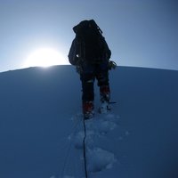
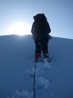
Night at the refugeWakeup at 2 am. Always the hardest part of mountaineering, getting up early. By 3, we were walking.
Yesterday, Marcial had drawn a sketch of our route: One hour going west on the saddle, followed by a rock pitch to gain the glacier, then two more hours to the summit. There would be a few crevasses to go around and the final push would be along the steep western ridge. Still, just three hours, that would be easier than I had expected.
The fresh snow changed all that. All the old tracks were covered. It was dark of course, so we had our head lamps and occasionally a bit of star light when the occasional clouds didn't obscure things even further.
Stress on the rocks
Marcial couldn't find the rock pitch. Eventually, he decided to climb at an alternative spot. It was a bit steeper than the normal route, but he figured it was possible. We roped up. He started climbing. He didn't place any protection, so I just waited. After a bit, he shouted that I should untie myself. I thought I hadn’t heard him correctly, but he repeated it. Not quite understanding why, I untied anyway, and he climbed a bit further. A few meters to the right of where he had started climbing I noticed a nice ramp, much easier than the direct route that Marcial had taken. I scrambled up it a few meters, where I could grab the rope again. When Marcial shouted I could follow, I went up. At one place, it was quite steep and my crampons didn’t find much purchase, but I managed to hook my ice axe on some rocks above me to get over it. At that point, I was glad I wasn't leading. After that, it got a bit easier and it didn't take me very long to reach Marcial. He had a good belay on the first flat bit of glacier.
He explained why I had to untie: when the rope got taught, he was still on a steep section where he couldn't set up a belay.
![Ice formation on Iliniza Sur]() This ice formation gives a good indication of the steepness of the slope
This ice formation gives a good indication of the steepness of the slopeHe just needed a few meters more! I already thought that he sounded slightly out of his comfort zone as he was shouting down instructions, and now I realized why: he was unprotected on a steep snow covered rock face and couldn't climb further because I was tied in to the rope. No wonder he sounded stressed!
The glacier
We had lost a bit more than an hour by now, but at least we had reached the glacier. From what I knew about the route, there would be some steep, possibly icy, sections on the glacier, making Iliniza Sur more technical than most other mountains in Ecuador. It so happens that I like steep ice, but now the snow came to our aid. Sure, the steep sections where still ... well, steep, but the fresh snow made it a lot safer. It wasn't enough to make trail breaking really tough, but I figured, if we fall, self arrest will be easy. So, as long as we avoid the crevasses, we'll be fine. I didn't dwell on the avalanche danger, I left that to Marcial to worry about.
![Iliniza Norte from Iliniza Sur]() Iliniza Norte appearing ... Iliniza Norte appearing ... |
![Iliniza Norte from Iliniza Sur]() ... summit's clear ... ... summit's clear ... |
![Iliniza Norte from Iliniza Sur]() ... there it is! ... there it is! |
We ascended for an hour on the glacier without any serious difficulties. By now, the morning clouds started to dissolve and we got great views of Iliniza Norte, covered by a lot more snow than normal in December.
Perhaps more importantly, we could clearly see our own route up to Iliniza Sur. There were some big, visible crevasses, but it was easy to go around them.
![Pico Ambato]() Pico Ambato
Pico AmbatoThen again, it's always the hidden ones you worry about ...
The summit
A bit later, I wondered about a little pointy thing in the distance. Would that be the summit? Marcial said it wasn't and I forgot about it. Later, I looked it up, it's called Pico Ambato. Not much lower than the real summit actually, and the direct route passes right over it. However, we were way to the west already.
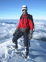
As we approached the summit, I was feeling wonderful. The altitude didn't trouble me at all, and we would make it, despite all the unexpected obstacles on our way! I could see Marcial already shining in the sun coming over the top, while I was still in the shade. We were almost there, and we would have a view!
I don't know exactly how long we stayed on the summit, but it certainly was a good while. Besides, we had earned it, it was our first rest of the day. We enjoyed sunshine, no wind and clear views from the summit. what more could a mountaineer wish for?
The descent
Eventually, we headed back down. It was too steep to slide, that would have been too dangerous, but we made good time chomping down anyway. From above and with excellent visibility now, it was easy to find the normal place for the rock scramble. It wasn't all that steep. In fact, Marcial told me to slide down instead of down climbing it, and so I did. The snow helped again. Mind you, he
did belay me, just in case, but it was pretty easy.
![Descending Iliniza Sur]() Looking back at the rock band: where would you go up?
Looking back at the rock band: where would you go up?
Back on the saddle, it didn't take too long for the clouds to come back. Still, it would be really hard
not to find the refuge, even in a total white out. There is hardly enough room between Norte and Sur to pass it by without seeing it!
Shortly before 9 and not far from the refuge, we encountered a group of three people. They wanted to climb Iliniza Norte, but, from the refuge, had followed our early morning trail. Lucky for them, they hadn't gone far yet. Marcial set them straight, but we both agreed that their chances of success would be slim. First of all, there was a lot more snow on Norte than usual, even than yesterday, making it harder, and secondly, considering that they already took the wrong turn right out of the refuge, how can they ever find the route where it goes down unexpectedly? I just hoped they would be turn back if it would become too dangerous ...
At the refuge, we had a huge meal. A short rest later, we packed our backs and headed down to the trail head, where Bladimir would pick us up for the ride to El Chaupi.
Later that day, I met the group of three we had seen earlier. As it turned out, they were also staying at El Chaupi. We had a pleasant chat and I learned that they were from Montana and had a lot of outdoor experience, a whole lot more than me in fact. However, due to the conditions on the mountain and some route finding issues, they had not made it to the summit. More importantly though, they made it down safe and in the end, isn't that what really matters?
![The Ilinizas from the Pan American highway]() The next day: A final look back at the Ilinizas from the Panamerican highway
The next day: A final look back at the Ilinizas from the Panamerican highwayBooks
The Andes – A Guide For Climbers, John Biggar, 3rd edition, July 2005. ISBN 0-9536087-2-7.
Bergführer Ecuador, Günther Schmudlach, 3e auflage, 2009. ISBN 3-926807-82-2.
This German book has good descriptions on many of the mountains in Ecuador, even though I have doubts about the quoted times - some were too short, others to long for me. A note on accommodation
The unsatisfactory hotel were I spent the first few nights was Hostal Jardín del Sol. Just so you know which one to avoid.
Later, I stayed at
Casa Helbling and I can really recommend that. Next time in Quito, I'll definitely want to stay there again. A really relaxed atmosphere and enormously knowledgeable, friendly and helpful staff to boot.


Comments
Post a Comment