
-
 8739 Hits
-
 72.08% Score
-
 2 Votes
|
|
Route |
|---|---|
|
|
0.659°S / 78.714°W |
|
|
Snow, Ice |
|
|
Half a day |
|
|
USA IV- / AD+ / 70 degrees |
|
|
Approach
This is one of Ecuadors “harder routes”. It includes steep climbing on snow/icy terrain, and route finding can be tricky since it is important to start early in the morning. Also, the route is snowy and care should be observed for crevasses.
Starting from the hut (see approach on Ilinaza Sur Page) follow the path towards the Ilinazas and at the head left toward the Ilinaza Sur, heading to the glaciar/lateral moraine.
 |
Route Description
There are apparently two ways to gain the glacier on Iliniza Sur:
1) The first is quicker, but potentially more dangerous due to ice on the traverse and steeper climbing to reach the glacier. For this option, follow the path from the hut to the top of the moraine crest and when the path splits, stay left and traverse across icy slopes (careful) and belowLa Rampa couloir itself and head towards an obviuos entrance to the route, at the far end of this icy slopes/glacier. Then climb the 45 degree icy slope which leads to the glacier as shown in the photos.
2) The second option is to follow the same path from the hut to the top of the moraine crest but then split off right, following cairns along the moraine crest itself, slowly dropping to the talus below after passing above La Rampa. Upon reaching the talus, an obvious path will be seen which traverses around a rocky ridge a few meters above. Follow this path (more cairns) with a large lake visible below until it is possible to climb up a sandy gully. Continue up the gully (marked with cairns), passing to the left of a rock wall. Immediately after passing the wall, an easy entrance to the glacier will be seen. The second option adds about 30 min to the climb and enters the glacier about 100 m lower. From here, zig-zag up (40 degrees) to reach the obvious snow slope. (Description courtesy of SP fellow Tom "Doctor" Fralich).
After Reaching the base of the climb, head up on this rock/icy 45 degree slope, that is like a funnel facilitating the entrance to a upper snow/glacier field. Depending on conditions and snow fall, this entrance can be an easy snow walk or an icy climb. Once you are up, you may want to continue up and left, but there is a lot of debris, an indication of rock fall. Better yet is to go a bit to the right, no more than 20 meters, and after passing a big rimaye/crevasse on your left, head up and straight.
Keep going up and straight on a slope that eventually will have some 50-60 degrees. The slope runs between some rock/ice clifs on the right and left, easily visible from the bottom of the
route. You will reach the top of this slope and here you must go right, negotiating 2 crevasses.
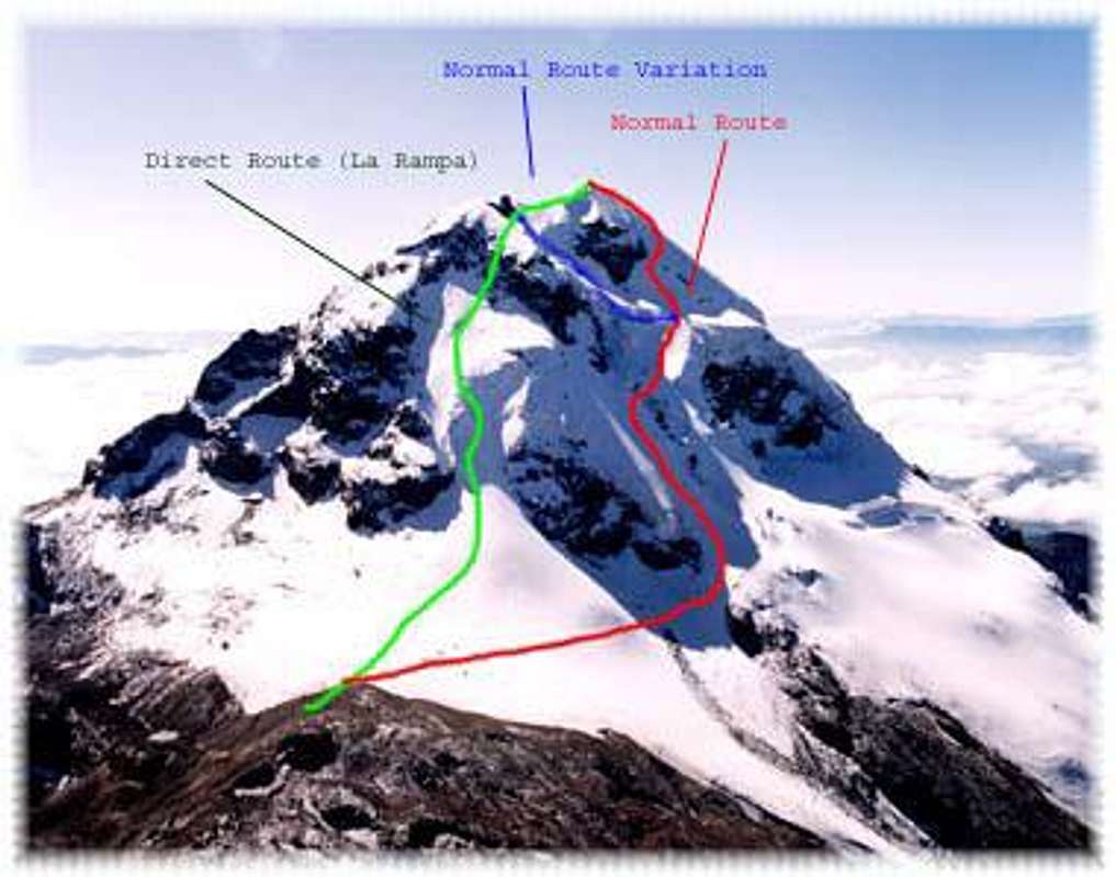
Here you have 2 options. Go left and into or around the crevasse and eventually climb a 3 mt 80 degree slope and keep going left and up, until you get below a first summit. Then keep going up and traverse to the right below a rock summit, called "El Hongo" (The mushroom) looking to reach a ridge, and joining another route to the summit called La Rampa Route. Cut below the main summit and then get to the left and up and join the ridge to the summit. (see Brain's guidebook). This route can be seen in blue in this picture.
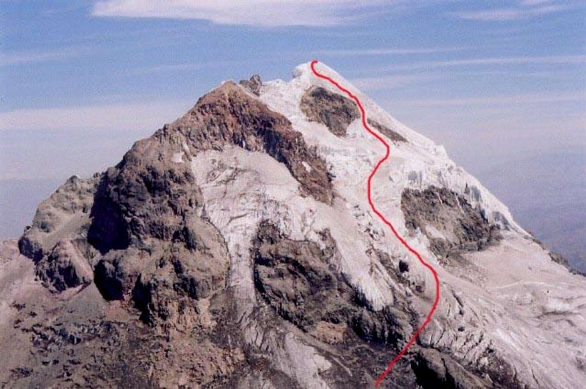
Other option woud be, after negotiating crevased terrain above, get up to the right side of the rocky outcrop below the main summit. Alternatively you can go directly if there is enough snow dividing the outcrop in 2. Once you negotiate the final slope (max 70 degrees, sustained) right to easier snow terrain and then left on the slope to the summit, as seen on this picture. Be careful with the cornise at the summit. (see Rachowiech guidebook). See red line on this picture.
The choice depends on the conditions, ice, snow and skills. Ask other climbers and the locals about the routes before you attemp any of the variations.
The decent will be the same. The whole climb may take 4-6 hours, and the decent 2-3 hours.
A trip report is included on IIinaza Sur Trip Report Page by Jason Connell
 |  |  |  |  |
Essential Gear
Mountaineering axe, maybe one north wall hammer or third tool for the leader, rope, few Ice screews plus one or two pickets to protect ascent and decent if team ability requires it, crampons.
Since this route is not climbed as frequently as many others in Ecuador, and in spite of its short lenght, a few wands are useful, specially for the lower section and for the crevasses on the route. If you review the summit log, you will see that many parties encountered cloudy conditionds with low visibility.
Miscellaneous Info
If you have information about this route that doesn't pertain to any of the other sections, please add it here.