
-
 2661 Hits
-
 76.66% Score
-
 7 Votes
|
|
Route |
|---|---|
|
|
47.07912°N / 9.76873°E |
|
|
Download GPX » View Route on Map |
|
|
Hiking, Scrambling, Via Ferrata |
|
|
Summer, Fall |
|
|
Most of a day |
|
|
Easy Via Ferrata |
|
|
Overview
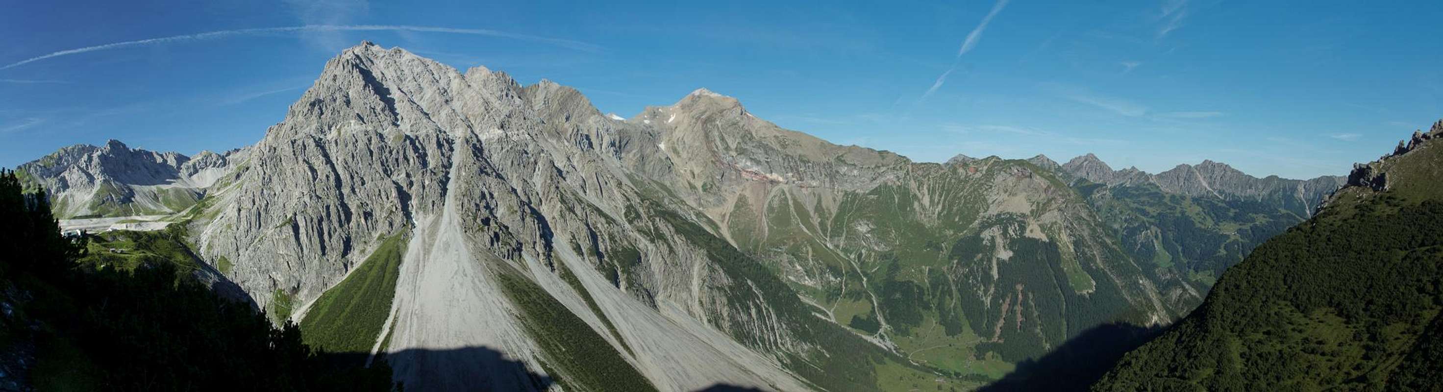
 Schesaplana Group seen from the lower south ridge
The normal route to Saulakopf is a short, 90min ascent from Saulajoch gaining a bit more than 500m elevation. However, there are two routes to get to Saulajoch from the trailhead at Douglasshütte, which can be neatly combined into a loop trail to fill a whole day. In addition it is possible (if time allows) to climb to the higher of the two summits of Schafgafall. With both summits you gain approximately 1200m elevation (see GPS track).
Most of the normal route is easy hiking. Certainly access to Saulajoch is, even though both access routes have their challenges on brittle worn out trails. From Saulajoch the route is steep but easy until you reach the south face traverse. Here several protective cables help you across exposed and sometimes polished ledges. The final part zig-zags through the west face of the mountain until, some 50m beneath the summit a polished slab needs to be mastered.
The protectied sections make the normal route appear in ferrrata guidebooks even though you'd never classify it as a real ferrata.
Getting There
 The trailhead is at Lünersee to the left
The trailhead for Saulakopf is at Douglasshütte, the top station of the Lünersee Cable-Car. The cable-car can be found at the very end of Brandner Tal. See the main page for information how to get there.
Route Description
- General:
- Start altitude: 1979m
- Summit altitude: 2517m
- Prevailing exposure: S, later W
- Type: Hike and protected scramble
- Protection: Short section in the south and west faces
- Start altitude: 1979m
- Effort: 1-2 - Elevation gain: 500m for Saulajochstei, 800m for the loop, 1200m if you climb Schafgafall
- Power: 1-2 - Easy
- Psyche: 2 - Some exposed sections
- Difficulty: 2 - Slab 50m beneath the summit is tricky even with protection
- Orientation: 1 - Marked and easy
Access to Saulajoch
Saulajochsteig
  |
The shortest access from Douglasshütte to Saulajoch is along Saulajochsteig. In generall it connects Douglasshütte with Heinrich-Hueter-Hütte and crosses the saddle about midway. It traverses the western slopes of Schafgafall high above Seetal, the very end of Brandnertal.
From the cable-car exit cross the panorama platform of Douglasshütte to reach the Lünersee Dam. Cross the dam and on the other side turn northward, descending a few metres. After a few steps a sign claims the path is closed. However, this only seems to apply to a short section to a material cable-car. A shortcut lets you skip this section.
 |  |  |
With a few ups and downs but mainly keeping elevation you cross the Schafgafall western slopes. In some places the path has broken away so take care. As you turn eastwards towards Saulajoch the views in your back open up and get more impressive. Saulajoch itself is a broad, slightly pronounced saddle. Hike through and descend a few metres until you reach the intersection with the Saulakopf Normal Route
Lüner Weg
 Lünersee seen from Lünerkrinne
Lüner Weg is the connection from Douglasshütte through the Lünerkrinne Saddle to Rellstal and Vandans. It is also used aas a roundabout hike towards Heinrich-Hueter-Hütte. For this it follows Gipsköpfleweg for the second part. The path is very popular as it stays pretty much at the same elevation (but more gain than Saulajochsteig).
Again, cross the panorama platform of Douglasshütte and the Lünersee Dam. The broad lake trail now ascends about a hundred metres with several switchbacks until an intersection is reached. The right hand path circles the lake while the left hand path heads for Lünerkrinne. If you intend to climb Schafgafall, look out for a small cairn to the left of the path. Here a scarsely marked trail leads to the southern )and higher) of the two summits.
 |  |  |
For Lünerkrinne stay on the main path which starts to climb to the saddle once it reaches the slopes to the south of it. Lünerkrinne is cut into very brittle stuff. A traverse from the saddle to Schafgafall is possible but dangerous. Rather use the trail mentioned above. From Lünerkrinne the trail, now almost a road, descends across Alpe Lün but before the farm building is reached, a sign points to Gipsköpfle, a minor summit of the group. After a second intersection (path leads to the Alpe Lün buildings) Gipsköpfle is reached, where an impressive view of both Saulakopf and Zimba opens.
Now take the brittle left hand path (right hand leads to Heinrich-Hueter-Hütte) and cross the Schafgafall north-east slopes. This path finally gets very steep (and brittle) heading up to Saulajochsteig halfway between the starting point of the Saulakopf Normal and Ferrata Routes.. Turn left and a few hundred metres before you reach the saddle the normal route starts.
Normal Route
 Seekopf, Zirmenkopf, Schesaplana, Wildkopf above Saulajoch
Now the path heads through dwarf pines heading for the south ridge of the mountain. It gets very steep, heading to where the south face breaks off at its eastern end. It passes a small gendarm and then touches the south-face directly.
The following section traverses the south face on ledges, which are protected in several sections. First a ledge takes you straight through the face to a deep gully, where some protective cables help you across the broken off parts of the path. The path heads steeply out of the gully reaching a small ridge, which it now follows for about 100m. Here you can see the nearby ferrata route, which in this section climbs a long free hanging ladder.
 |  |  |  |
Reaching the sloped west face of Saulakopf the path leaves the ridge and starts to zigzag through the face until it reaches a worn out polished part. Here protective cables help you climb that section, which is very steep and requires big steps between the safe foot placements. Once above this crux the path heads back for the south ridge (from where the ferrata joins) which it climbs (some exposure) towards the top.