
-
 4569 Hits
-
 74.92% Score
-
 5 Votes
|
|
Route |
|---|---|
|
|
48.70930°N / 113.638°W |
|
|
Scrambling |
|
|
Summer, Fall |
|
|
Most of a day |
|
|
Class 3 |
|
|
GMS II(3)LM |
|
|
I |
|
|
Overview
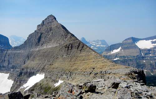
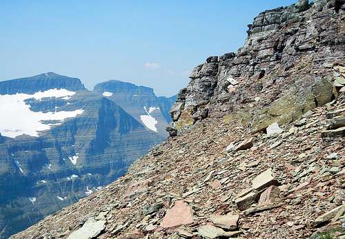
Matahpi Peak from Point 8727 - the route follows the ridge to blocking cliffs, then traverses to the right
Total distance: About 6.4 miles with a vertical gain of 3,515 feet. (Round trip about 12.8 miles)
High point of trail to the summit: About 1.7 miles with about 1200 feet of gain.
I am going to call this the NE Route rather than the NE Ridge Route because it does not finish via the NE Ridge. I do not know if anyone has climbed the upper cliff band to the summit from the north or west.
This route follows the NE Ridge of the peak for much of its length. There does not appear to be a scrambling route through the upper cliff band of the peak anywhere on the north or west sides (if there is one, I missed it – and I looked hard), so those not prepared for Class 5 climbing must traverse around the upper part of the peak and finish via the upper part of the South Slopes Route.The Edwards Guide does not include Matahpi Peak, but does very briefly mention it associated with Going-to-the-Sun Mountain and includes the following "Matahpi Peak Route" on GTTS:
“From Siyeh Pass, climb over the top of Matahpi, then descend to the saddle between that peak and Going-to-the-Sun, where the route joins the west face route described above. “Climb Glacier Park,Volume One includes Matahpi and mentions the possibility of descending to Siyeh Pass, but strongly recommends against it. It does not mention this as an ascent route.
I don’t think that it is quite as straight forward as Edwards makes it sound nor as dangerous as Climb Glacier makes it sound. I will just describe it here and let you decide on whether to use the route up and / or down.Edwards does not point out that there is not a scrambling route through the upper cliff band on the north side of the peak. You must traverse under the cliffs around to the south slopes to get to the summit –thus you do not literally “climb over the top” and then descend to the saddle –going to the top would be a side trip on the way to the saddle.
If you are patient and willing to zigzag a lot, the entire route can probably be climbed at Class 2,but most scramblers will probably opt to do some short Class 3 steps to avoid scree and some the back and forth. I did not put my trekking poles away on the entire trip.
Approach
The route starts at the high point of the Siyeh Pass Trail. The shortest way to there is from the Siyeh Bend trail head. See the description on the main page.Route Description
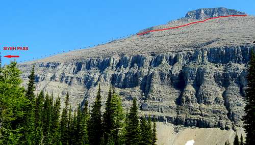
NE Route Matahpi Peak - Enlarge for greater detail.
Ascent
As you approach the highpoint of the trail, you will see some use trails through the scree leading up to the NE Ridge. These are great on the descent, but for better footing on the ascent, continue up the trail and follow it around the corner then climb directly up the ridge from just around the corner.
Staying close to the ridge crest will lead you to the top of Point 8727 from there you get an excellent view of the upper part of the peak and the remainder of the NE Ridge. It is also quite obvious from there that you will not be scrambling up the ridge crest to the summit. From Point 8727, descend to the saddle in the ridge and continue to follow close to the ridge crest without difficulty until you reach a white colored vertical step which stops easy progress. As you traverse climber’s right, you will note that there are ledges and breaks that would probably allow you to climb this step (Class 4?), but if you continue far enough there is an easy break that can be walked up. From there, you could traverse back to the ridge crest, but there would be little gained by doing so. Instead, make a gently rising traverse to the right on faint goat trails to base of the upper cliff band. There you will find a good goat trail that leads around to the south slope. Finish to the summit on the upper part of the South Slopes Route.
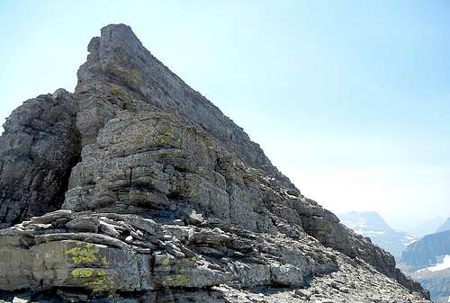
The vertical step that stops easy progress.
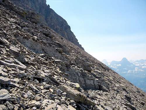
The slope that must be ascended to the base of the summit cliffs.
Descent
In case you did not ascend the route - here are some hints for the descent.
Descend from the summit to the base of the cliffs. Follow the base of the cliffs westward. When you turn the corner on to the west side of the peak, you will be on a good goat trail along the cliff base.
Follow this trail for several hundred yards watching for faint goat trails (and possibly a few cairns) descending at a gentle angle to the northeast. If you have not started descending before you get to the buttress that extends lower than the rest of the cliff, start there (see photo). Note that if you get cliffed out you can get around the cliffs by turning back to your left (facing downhill). Once below the cliff band blocking the NE Ridge, traverse to near the ridge crest and follow it down. You can easily bypass Point 8727 on the left if you do not feel like climbing over it. Be sure to traverse to the ridge crest and follow the ridge down – any descent further west will lead you to the top of dangerous cliffs.
Base of the cliffs on the south side - go around the corner at the base of the cliffs to reach the good goat trail on the west side
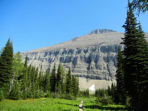
Matahpi Peak from the NW (Preston Park) - Note the cliff band at the base of the peak - if descending this side, you need to traverse to the ridge to safely reach the Siyeh Pass Trail
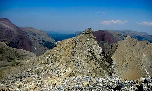
Point 8727 from the SW - it can be easily bypassed on the left if you do not want to climb over it on the descent